In any emergency, knowing where to go can make the difference between safety and catastrophe. Growing up in Oklahoma, I am attuned to this reality. I knew all the local meteorologists by name, trusted their advice and guidance during storms, practiced taking shelter during tornado drills in school, and knew to take shelter below ground or in an interior room with no windows. When a tornado was coming, I knew what to do—and more importantly—where to go, and this guidance did not change between storms.
For those living in areas that are prone to potentially catastrophic events, like tornadoes, earthquakes, or volcanic eruptions, the split-second decision of where to go once disaster strikes can be a matter of life and death. Many countries in the Global South are particularly vulnerable to risks imposed by earthquakes and subsequent landslides due to their complex geography. The changing landscape means that where residents should evacuate during an earthquake can change in between events. These changes create difficult situations for local public safety organizations who work to ensure their communities’ safety by effectively providing the most up-to-date guidance to those within their jurisdiction.
Open Spaces as the Heartbeat of Community
Open spaces like fields, parks, and school playgrounds are an important element in disaster response and recovery infrastructure. They play a critical role as a place to evacuate to during disasters. They also act as staging areas for humanitarian aid distribution, medical assistance, meeting points for those separated during a disaster event, heliports for aid delivery, and temporary shelter until it is safe for residents to return home. In some communities, the nearest open space may be easily identifiable and a part of the daily lives of those that live near it, like a public park. However, in some areas, the nearest open space to evacuate to may be an undeveloped lot or land owned by the local government or municipality that is not a place for recreation. In areas prone to earthquakes, the status of the open space where residents evacuated to in the last event could have changed, either being unreachable due to damage caused by an earthquake or the land being developed.
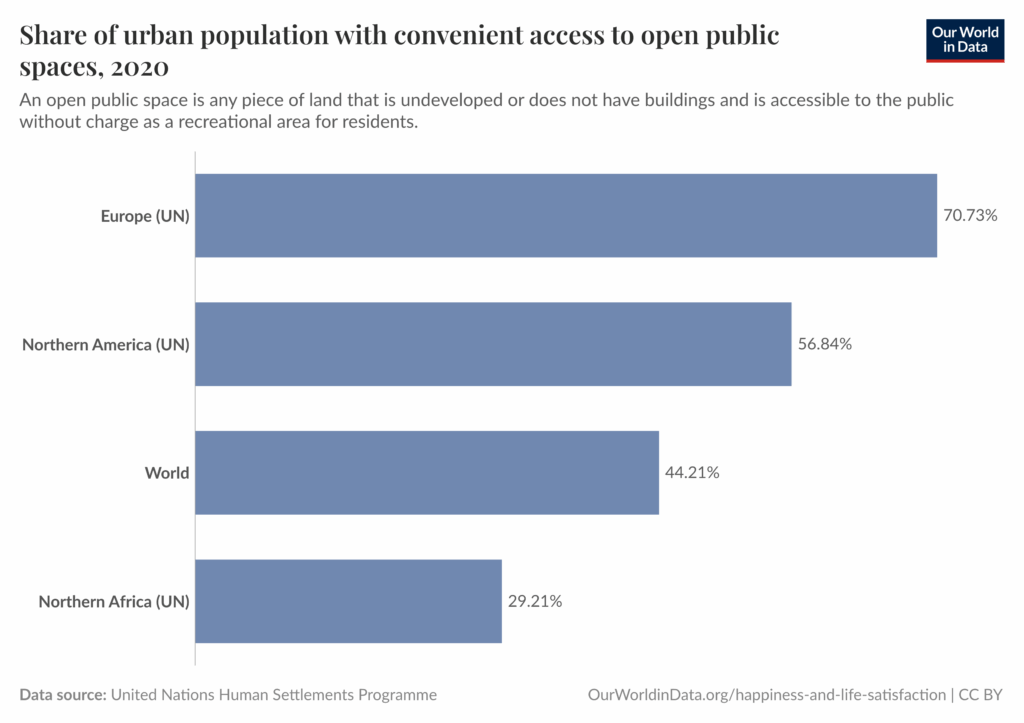
Open spaces can also be used to help mitigate risk from floods and tsunamis, acting as buffers around flood-prone developed areas. These areas can be dual-purpose, both mitigating risk from natural disasters, and creating spaces like wildlife habitat areas and nature-focused outdoor activities. Open spaces act as the heartbeat of a community, providing safe and accessible areas for gathering, relaxing, and recreation. The importance of accessible, inclusive open public spaces is also defined in the United Nations’ Sustainable Development Goal 11 to “make cities…inclusive, safe, resilient, and sustainable,” through Target 11.7, “Provide access to safe and inclusive green and public spaces.”
GIS and Earth Observation to Identify Open Spaces
The geographic approach is a way of thinking and problem-solving that integrates and organizes all relevant information in the crucial context of location. It also helps public safety professionals that work in challenging environments by providing unique ways to investigate the landscape and identify open spaces. Geographic information system (GIS) technology and Earth observation, like satellite or drone imagery collection, can provide detailed information on hard-to-reach locations. Evacuation areas can be identified through analyzing imagery, plus, their status can be monitored and updated through Earth observation, along with geographic-based communication and tools. ArcGIS StoryMaps and ArcGIS Hub can aid organizations in effectively communicating relevant information to their constituents about evacuation areas and keeping them updated during hazardous events.
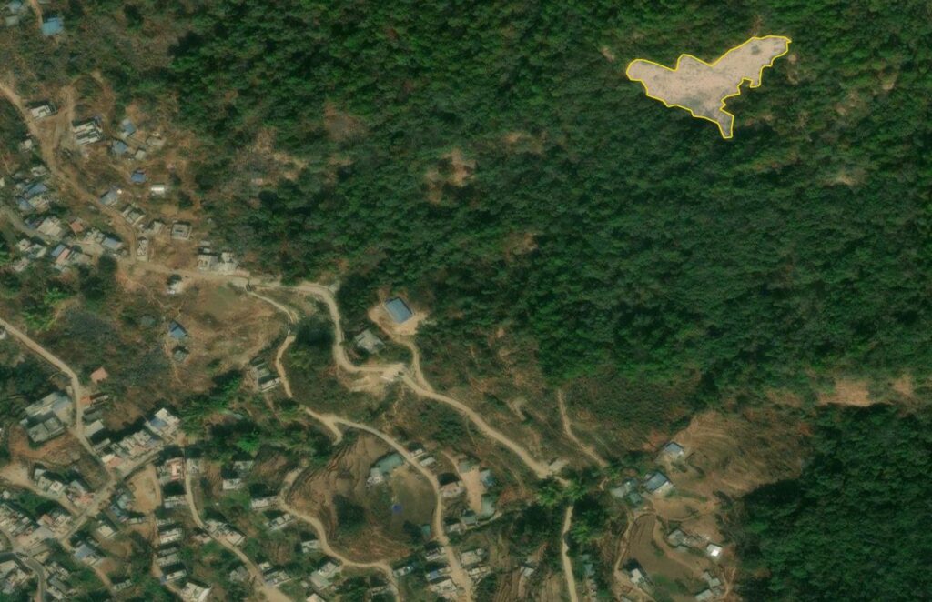
Nepal Open Space Mapping Project
Following the devastation of the 2015 earthquakes in Nepal, the International Organization for Migration (IOM), in partnership with the Ministry of Home Affairs and Ministry of Federal Affairs and General Administration of Nepal, began a project to identify open spaces in the eight worst affected areas, both rural and urban. The project combined Earth observation technology and geographic analysis, to identify new open spaces and check the status of previously identified open spaces, as well as community engagement workshops with those in earthquake-prone areas. In coordination with a local drone operator, Nepal Flying Labs, high resolution drone imagery was captured to provide more details over open spaces initially identified through satellite imagery analysis. In Gorkha Municipality of the Gorkha District, which was the epicenter of the 2015 earthquake, 90 percent of the population was displaced and took shelter in open spaces, which helped to illuminate the need for further identification and monitoring of these spaces across Nepal for impending quakes. The project identified 11 officially designated open spaces in Gorkha Municipality, which could support approximately 16,452 people. In Kathmandu Valley, the project found that of the open spaces identified in 2013, 10 were no longer usable at all. Of the 73 remaining, there had been a reduction or change in the usable area. This highlights the importance of continued monitoring after open spaces are identified to ensure accurate information on their status.
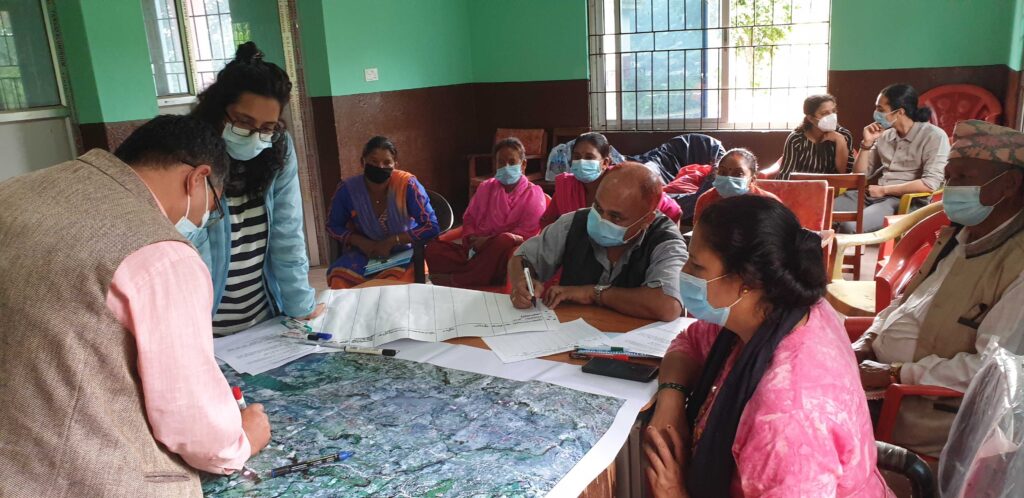
Once the open spaces were identified, the high-resolution map products and corresponding data that were created were shared with the local planning and development agencies of the local governments to help aid in the preservation, maintenance, and future development of the areas. The information was also shared with the public through multiple mediums, including a large-scale, printed community map with open spaces identified, placed where most residents could see it as well as a hard-copy map atlas, which includes details of all the open spaces and what amenities they include. The information was also added to the Open Space for Humanitarian Purposes platform, which is an online repository of identified open spaces, and to the Open Space mobile application, which functions both online and offline, and includes navigation capabilities. This project highlights how the application of the geographic approach can help communities recover from disasters, plan for future events, and share accurate information with those living within their jurisdiction.
Future Resiliency
The combined use of a workshop with residents, using their lived and known geographic knowledge, with Earth observation and geographic analysis, could be repeated in other disaster-prone areas to help reduce risk and build more resilient communities. Additionally, improvements in the following areas could also help to increase the application of GIS in disaster response and improve community resiliency:
- Increased availability of high-resolution satellite imagery through open data programs following global disasters
- AI models trained using data from communities vulnerable to disasters in the Global South, where infrastructure is different than areas in the West
- Increased collaboration and data sharing between organizations working in public safety and disaster response
Learn More
To learn more about how GIS can unlock the full potential of imagery, visit our Imagery and Remote Sensing capabilities page or download our ebook.