Customer Spotlight Story
Lee County Electric Cooperative (LCEC) has served Southwest Florida’s energy needs since 1940, when it began with just 158 members and 15 miles of distribution line. Today, the not-for-profit electric distribution cooperative serves more than 268,000 members across six Florida counties and is one of the largest electric cooperatives in the United States. Headquartered in North Fort Myers at the same location where the cooperative originated, LCEC employs approximately 400 people across its service territory to provide reliable, cost-competitive electricity around the clock.
As a member-focused cooperative, LCEC operates at the cost of service rather than generating profits for investors. Its values reflect a longstanding commitment to its members and the Southwest Florida communities it serves. These values include safety, customer service, integrity, respect, teamwork, accountability, and stewardship. Over more than 85 years, LCEC has grown alongside the region, expanding its infrastructure and capabilities while earning recognition for its industry leadership, community involvement, environmental efforts, and workplace practices. That growth continues today as Southwest Florida experiences ongoing development and the challenges of hurricanes, flooding, windstorms, and other severe weather. LCEC’s commitment to reliability, innovation, and responsible stewardship helps the cooperative meet the evolving energy needs of a large and growing service territory.
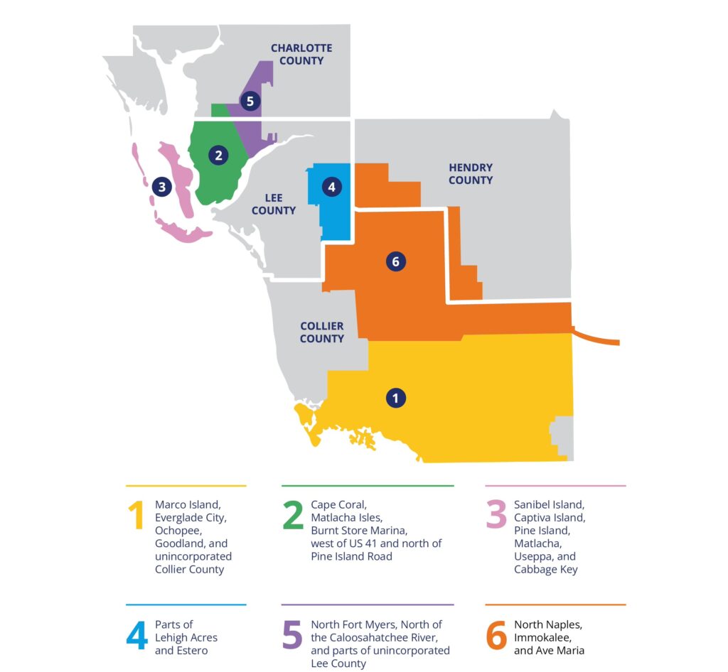
LCEC serves six counties in Southwest Florida.
LCEC has a long history of using GIS to support its operations. By 2002, the cooperative had implemented an Esri-based GIS that supported daily operations, including field engineering and outage response, establishing a strong foundation for its continued use of geospatial technology.
CHALLENGE
LCEC has added roughly 10,000 members annually over the past two years, bringing a steady stream of new infrastructure that must be accurately mapped. A single installation can include hundreds of asset locations, making efficient and reliable field data collection increasingly important as the cooperative’s network expands.
At the same time, LCEC’s legacy GPS equipment provided only about 22 to 24 inches of horizontal accuracy and no elevation data. In storm-prone Southwest Florida, those limitations had real operational implications. When poles or other equipment were damaged or displaced, more precise coordinates could help crews locate assets and support restoration efforts. Elevation was equally important for understanding whether storm surge or flooding may have reached and compromised equipment such as pad-mounted transformers. With a growing network and increasingly demanding field conditions, LCEC needed to capture more complete and precise location information, both horizontally and vertically, while keeping the process practical for crews collecting hundreds of points in the field.
SOLUTION
In 2025, LCEC discovered Eos Positioning Systems’ high-accuracy GNSS technology. The receivers provide real-time 3D coordinates and connect to the free Florida Department of Transportation Real Time Kinematic (RTK) network. This gives the team the horizontal and vertical precision it needed. Just as importantly, the technology works with LCEC’s existing NISC and Esri environment. Once connected to RTK, the improvement in positional accuracy was immediately apparent. That precision is especially valuable after a major storm, when a pole or other asset may be damaged, displaced, or completely gone.
LCEC configured the Skadi 300 RTK receiver for use with the Esri GIS-enabled NISC mobile app. Paired with the LiDAR-powered Skadi Smart Handle, the setup eliminated the need for a physical range pole while making field collection faster and more ergonomic. Mobile workers can hold the equipment and their tablet in one hand, simplifying the process of capturing large numbers of asset locations in the field.

LCEC worker captures precise location information.
The technology also gives the team more flexibility when assets are difficult or unsafe to reach directly. For locations across canals, behind obstacles, or in other obstructed areas, workers can capture accurate positions from a distance, helping LCEC collect the precise location and elevation data it needs without requiring crews to physically occupy every point.
PARTNER
Eos Positioning Systems (Eos) is an award-winning Esri Gold Partner and designer and manufacturer of Esri-integrated GNSS receivers. Eos works closely with Esri and NISC to ensure its technology integrates seamlessly for electric cooperatives, utilities, and other utility professionals. Eos GNSS receivers, including the Skadi 300™, are compatible with the Skadi Smart Handle™ for more efficient, safer, and ergonomic field data collection directly into ArcGIS apps and partner applications such as NISC Mobile.
RESULTS
The improved workflow has made it easier to locate meters, pedestals, and other infrastructure and map accurately. The GIS team has also begun updating the locations of older equipment that can be challenging to find, as well as assets identified by designers for improved location accuracy.

LCEC worker captures images from a moving vehicle.
The ability to point, capture, and continue moving has streamlined field data collection, helping the team capture accurate locations more efficiently. With better spatial accuracy, designers and field staff can also locate assets more quickly, including during outages and after major weather events.
“The ability to point, capture, and keep moving makes collecting accurate locations much easier.”— Leah Maldonado, Supervisor, Systems Graphics Team, Lee County Electric Cooperative
BENEFITS
For LCEC, greater accuracy and a faster field workflow translate into time savings across both GIS and field operations. GIS staff can collect the information they need with less interruption to lineworkers, allowing crews to return to their primary work sooner.
More precise asset locations also provide added value when LCEC needs the information most. During restoration efforts or damage claims, crews can find infrastructure more easily, supporting faster response and power restoration.
As LCEC continues to grow, accurate data, efficient field collection, and easier asset location help the cooperative maintain reliable service while delivering greater value to its members.
NEXT STEPS
With the new workflow in place, LCEC is beginning to revisit older infrastructure where location data can be improved. The GIS team is updating difficult-to-locate assets and responding to requests from designers for more precise locations, steadily improving the accuracy of LCEC’s existing system data.
SUMMARY
Challenge: Rapid member growth, expanding infrastructure, and severe weather risks created a need for more precise horizontal and elevation data than LCEC’s legacy GPS equipment could provide.
Solution: LCEC implemented Eos high-accuracy GNSS technology with RTK, integrated with its existing Esri and NISC environment, to capture precise 3D asset locations more efficiently in the field.
Results: The new workflow streamlined field data collection, improved asset location accuracy, and made difficult-to-access infrastructure easier to map and locate.
Benefits: More accurate asset data and faster field collection save staff time, reduce interruptions to lineworkers, and help LCEC locate infrastructure and restore power more quickly when it matters most.