Customer Spotlight Story
Hull Municipal Light Plant (HMLP) is a municipally owned electric utility that has served the Town of Hull, Massachusetts since 1894. Today, HMLP delivers safe and reliable electricity to more than 6,000 customers across the town’s approximately 10-square-mile peninsula, which features nearly 27 miles of oceanfront coastline. Governed by an elected Board of Commissioners and led by the Operations Manager, HMLP is responsible for maintaining, expanding, and modernizing the community’s electric distribution system.
HMLP has also established itself as a forward-thinking utility in its use of geographic information systems (GIS). In 2021, Esri highlighted HMLP’s digital transformation as a customer success story by implementing ArcGIS Enterprise and ArcGIS Pro. Read the story. This commitment to GIS demonstrates HMLP’s focus on leveraging technology to improve efficiency while continuing to provide exceptional service to its customers.

Hull is a picturesque New England coastal community.
This story is a continuation of HMLP’s digital transformation journey.
CHALLENGE
As a small, municipally owned electric utility serving a densely populated coastal community, HMLP continues to face growing pressure to modernize its operations while continuing to provide reliable service with limited staff and resources. Previously, field workers relied on paper-based processes to collect inspection data, which then had to be manually entered into AutoCAD drawings. This resulted in delays and inefficiencies in keeping system information up to date. In addition, the lack of integration with other systems limited the organization’s ability to support streamlined workflows and quick decision-making both in the office and in the field.
“The inspection forms in ArcGIS Field Maps have streamlined our inspection processes. We are no longer fumbling with piles of paper or filing inspections that will soon be forgotten.” Mike Schmitt, Operations Manager, HMLP
Critical asset information continued to be maintained through a combination of paper inspection forms, AutoCAD drawings, spreadsheets, and disconnected data sources, making it difficult to maintain an accurate, up-to-date view of the electric distribution system. Field crews recorded inspections on paper, required manual transcription back in the office, a time-consuming process that delayed updates, introduced opportunities for error, and limited visibility into system conditions.
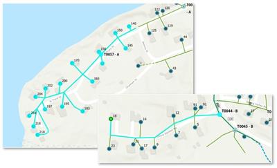
ArcGIS Utility Network provided advanced tracing capabilities.
Without an integrated GIS, staff were limited in their ability to perform advanced tracing or seamlessly share information between the office and the field.
SOLUTION
To achieve an accurate outage management system, HMLP migrated from AutoCAD to ArcGIS Enterprise and ArcGIS Utility Network. This migration not only addressed paper inefficiencies and limited network modeling capabilities but also positioned HMLP for a more reliable, scalable, and performant network management foundation that was extended to the field for offline mobile inspection workflows.
With this information centralized in ArcGIS Enterprise, HMLP now benefits from a single, authoritative source of network data, enabling field crews to use ArcGIS Field Maps for digital inspections instead of paper. The modernization extended beyond the office to the field. ArcGIS Field Maps replaced paper-based inspection workflows with digital forms that enable field crews to collect and update asset information directly from mobile devices, even when working offline. Inspection data is synchronized back to ArcGIS Enterprise, giving office and field personnel access to the same current, authoritative information. By combining ArcGIS Enterprise, ArcGIS Utility Network, and mobile GIS applications, HMLP established a single enterprise platform that improves data quality, streamlines daily operations, and equips the utility with a resilient foundation for continued digital transformation.
PARTNER
HMLP selected RINA as a trusted partner in the utility sector based on its strong track record delivering GIS and engineering solutions for gas, electric, and telecommunications organizations across the U.S. As an Esri Gold Partner, RINA offers a full-service GIS shop that supports clients through every stage – from system architecture and implementation to post-migration support and custom web / mobile development.
Hull Light partnered with RINA to migrate its legacy AutoCAD data into an enterprise geodatabase, transforming it into a customized ArcGIS Utility Network-ready data model.
RESULTS
HMLP successfully modernized its electric network by migrating legacy AutoCAD data into ArcGIS Enterprise and implementing ArcGIS Utility Network as its authoritative system of record. Working with RINA, HMLP transformed disconnected CAD drawings into ArcGIS Utility Network ready enterprise geodatabase that accurately models the utility’s distribution network.
Using the technology’s nonspatial objects, HMLP incorporated detailed meter information from Eaton advanced metering data into the enterprise GIS, creating a connected network model that links transformers, services, and customer meters. After enabling network topology, the utility established transformer-level subnetworks that support advanced network tracing, making it possible to quickly identify downstream meters and improve network visibility. This connected network information was also integrated with the NISC platform to support more accurate outage management.
The implementation extended beyond the office with the deployment of ArcGIS Field Maps for digital inspections. Field crews now collect and update asset information using mobile devices, even while working offline, with data synchronized directly to ArcGIS Enterprise. The result is a centralized enterprise GIS that serves as the single source of truth for HMLP’s electric distribution system.
BENEFITS
Migrating to ArcGIS Enterprise and ArcGIS Utility Network has delivered substantial gains in data quality and operational efficiency for HMLP. Establishing a reliable, up-to-date network information management system has laid the foundation for future integrations with AMI and OMS.
By replacing paper-based workflows and disconnected legacy systems with an enterprise GIS, HMLP has significantly improved the quality, accessibility, and reliability of its network data. Office and field personnel now work from the same current information, eliminating duplicate data entry, reducing manual processes, and improving confidence in operational decisions.
ArcGIS Utility Network provides HMLP with a comprehensive understanding of network connectivity, transformer loading, and meter relationships, enabling staff to perform network analysis and tracing in minutes rather than hours. Digital inspections completed with ArcGIS Field Maps have accelerated data collection, reduced turnaround times, and improved the accuracy and completeness of asset information. Most importantly, HMLP now has a scalable technology platform that supports both current operations and future innovation. With a reliable, enterprise-wide system of record in place, the utility is well positioned to expand its integration with advanced metering infrastructure, outage management, and other operational systems while continuing to deliver safe, reliable electric service to the Hull community,
NEXT STEPS
As HMLP looked toward future initiatives, including advanced metering infrastructure (AMI), improved outage management, and mobile field operations, it continues its digital transformation journey as it looks to integrate with other operational systems leveraging ArcGIS Utility Network and recognized the need for a centralized, enterprise GIS that would serve as the authoritative source of network data and provide a scalable foundation for future innovation.
SUMMARY
Challenge – HMLP needed to modernize its electric network by replacing paper-based inspections, legacy AutoCAD drawings, and disconnected data sources with an integrated GIS that could improve operational efficiency, support advanced network analysis, and prepare the utility for future initiatives.
Solution – HMLP partnered with RINA to implement ArcGIS Enterprise, ArcGIS Utility Network, and ArcGIS Field Maps, creating a centralized system of record that supports digital inspections, advanced network modeling, and enterprise-wide access to accurate network information.
Results – The utility successfully migrated its legacy data into ArcGIS Utility Network, established a connected network model with advanced tracing capabilities, integrated metering information and outage management workflows, and replaced paper inspections with mobile GIS.
Benefits – HMLP now operates from a single authoritative source of network data, enabling faster decision-making, improved data quality, streamlined field operations, enhanced outage response, and a scalable GIS platform that supports continued digital transformation.