Challenge
The Town of Paradise, California, faced significant challenges after the devastating 2018 Camp Fire, which heavily impacted the town and its infrastructure. One of the infrastructures that were severely affected was the storm drain network, with PVC pipes melting away. As part of the Town’s Long Term Recovery Plan, the need to re-establish the storm drain infrastructure was identified to guide the reconstruction efforts and make the town more resilient to future storm runoff impacts and develop a strategy to mitigate flooding risks.
Partner
Wood Rodgers Inc. (Wood Rodgers) is a multidisciplinary engineering, planning, surveying, and mapping consulting firm headquartered in Sacramento, California. The team works seamlessly with other designers, engineers, public agencies, and private clients to provide quality engineering services, while meeting the environmental constraints of each project.
Solution
Wood Rodgers was selected by the Town of Paradise to develop a comprehensive Storm Drain Master Plan (SDMP). Leveraging Esri technology and the ArcGIS platform, Wood Rodgers utilized GIS processes to analyze data, identify deficiencies, and develop cost-effective solutions. The team updated the GIS data received from the Town and conducted a modeling process to identify deficiencies and problem areas in the storm drain network. The GIS Group conducted extensive data collection, review, organization, and documentation efforts to build a digital base map of the existing drainage system infrastructure using ArcGIS Enterprise. To facilitate collaboration, Wood Rodgers created an AEC Project Content Delivery site using ArcGIS Online. This platform allowed for information sharing with the town, stakeholders, and subconsultants involved in the project. The collaboration site enabled the use of ArcGIS Survey123 for condition assessments of the storm drain infrastructure, streamlining data collection in the field and monitoring progress. Web maps were also created to share georeferenced as-built drawings and existing storm drain infrastructure, documenting the project’s progress.
The team utilized GIS processes to prepare and manage the data used in the hydrology and hydraulic model. Challenges in the modeling effort, such as the lack of precise survey data for culverts, were overcome by leveraging GIS workflows. GIS was used to set culvert invert elevations based on pipe size and ground elevation, saving time and effort. The model’s results, depicting surface flooding in a two-dimensional mesh, were converted to a raster surface using a Python script for better visualization.
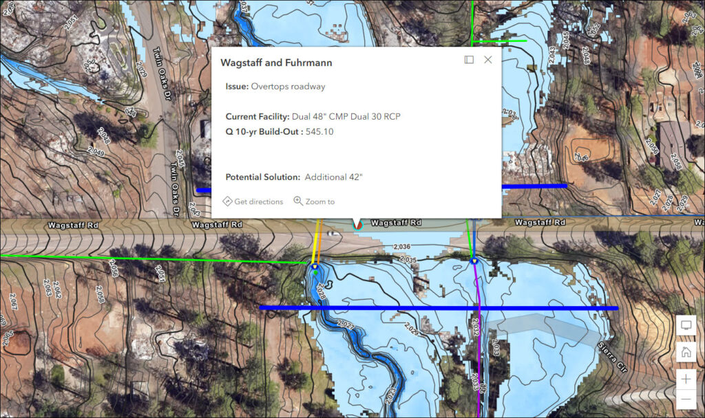
Wood Rodgers identified key locations that required immediate attention and developed a cost estimation tool using GIS applications like ArcGIS Experience Builder. This tool allowed engineers to quickly sketch potential improvements and estimate costs.
Additionally, Wood Rodgers created a flood information tool that provided exhibits for every impacted parcel in Paradise.
This tool helped residents understand the flood extents and make informed decisions about rebuilding their homes. It showed them how far they needed to be from flood events and the projected flood elevations, enabling them to adjust their structures accordingly.
Results
The storm drain master plan developed by Wood Rodgers and the Town of Paradise has had significant positive impacts. The town can now support the rebuilding process for individual home builders by providing flood information and guidance on where and how to build. Wood Rodgers generated parcel maps showing flood extents for all 11,000 parcels in the town, helping residents make informed decisions about rebuilding.
The SDMP recommendations for projects to reduce flooding and correct material deficiencies will help the town prioritize its rebuilding efforts. The plan has provided a roadmap for infrastructure improvements, ensuring the town is better prepared for future flooding events.
The plan has provided a roadmap for infrastructure improvements, ensuring the town is better prepared for future flooding events.
The collaboration between Wood Rodgers and the Town of Paradise has been recognized for its excellence. Wood Rodgers received an award from the American Society of Civil Engineers (ASCE) for this project.
Learn more about location intelligence for AEC:
GIS for Architecture, Engineering, and Construction.
Stay Connected with Esri’s AEC Team:
Subscribe to the AEC industry newsletter “Esri News for AEC”.
Join Esri’s Architecture, Engineering and Construction Community.
About the author