South Carolina is no stranger to the devastating impacts of hurricanes that leave lasting effects on residents and communities. Effective hurricane response and recovery requires close coordination among federal, state, and local agencies. At the state level, the South Carolina National Guard (SCNG) plays a crucial role in these efforts and relies on elements of the 117th Engineer “Pioneer” Brigade to provide tailored engineering support to civilian agencies.
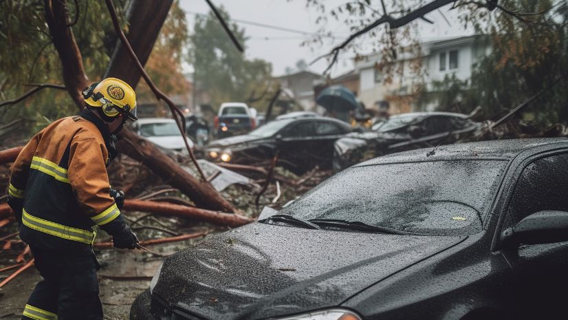
Hurricane Helene proved particularly challenging across the Southeast carrying its devastation well inland from coastal areas. In South Carolina, the storm struck in areas that are less accustomed to dealing with severe hurricane impacts. The sheer volume of vegetative debris, extensive road closures, and widespread power and communications outages compounded the difficulty of establishing a clear common operating picture.
Focusing internally on supporting their residents, western counties were initially overwhelmed. This initial impact hindered situational awareness — namely, the ability to understand the full scope of the disaster and decipher how to rapidly prioritize resources. After struggling to gain a solid understanding of the situation, the SCNG integrated Geographic Information Systems (GIS) tools that significantly changed the response.
ArcGIS Powers Damage Assessment, Situational Awareness, and Recovery
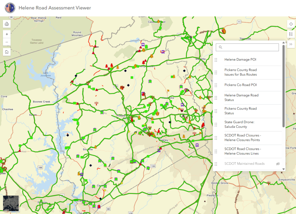
The immediate challenge was to cut open roads for emergency responders followed quickly by assessing damage to infrastructure and utilities. The SCNG turned to ArcGIS Online, a cloud-based platform developed by Esri, to gain insight into real-time data visualization and analysis. The SCNG GIS office partnered with the Pioneer Brigade to harness the capability to gain clarity regarding the destruction by using satellite imagery, drone data, and crowdsourced information. The SCNG created detailed damage assessment maps that helped visualize the storm’s impact.
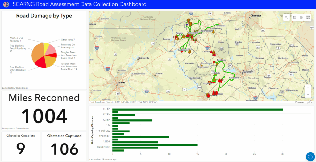
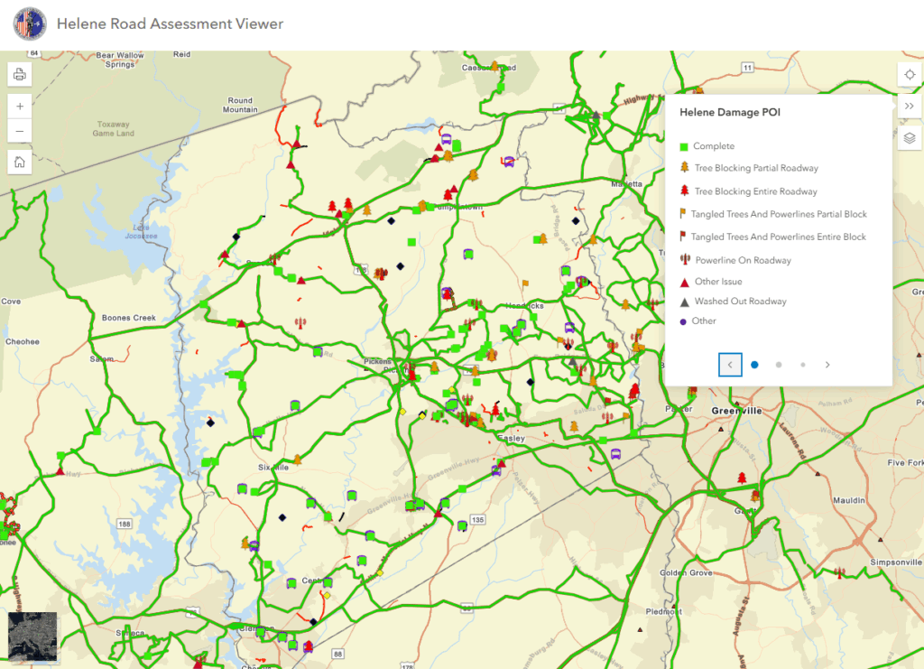
Using tools like ArcGIS Survey123 and ArcGIS Quick Capture, SCNG quickly integrated crowdsourced reports from National Guard Soldiers, first responders, and even residents across the state. To bolster situational awareness, SCNG overlayed the crowdsourced data over county and state road-closure data within SCNG’s custom apps. Planners were able to use this knowledge to prioritize mission-planning efforts and employed engineering assets more efficiently to clear vegetative debris and restore access.
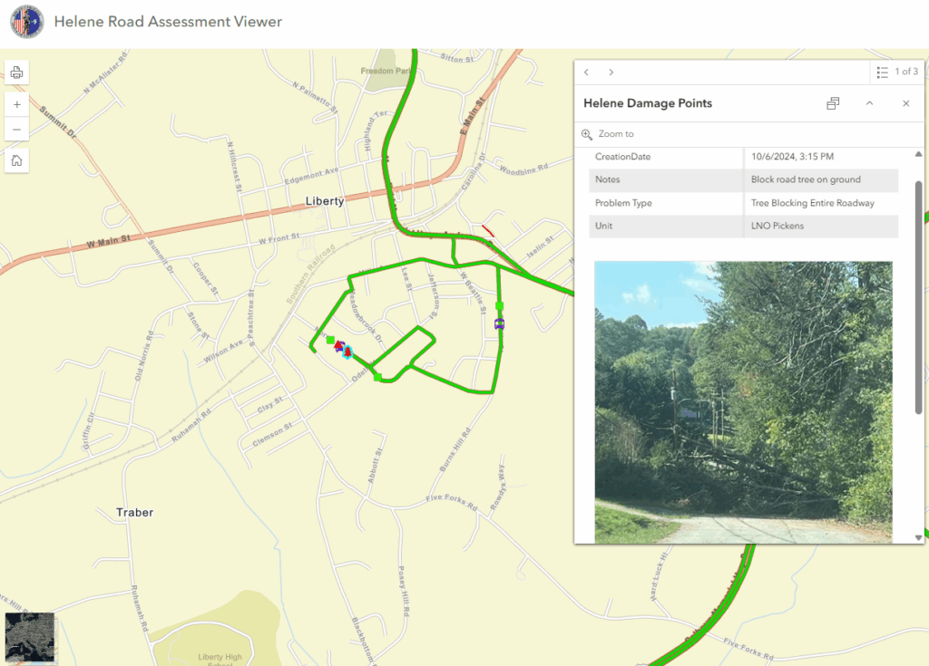

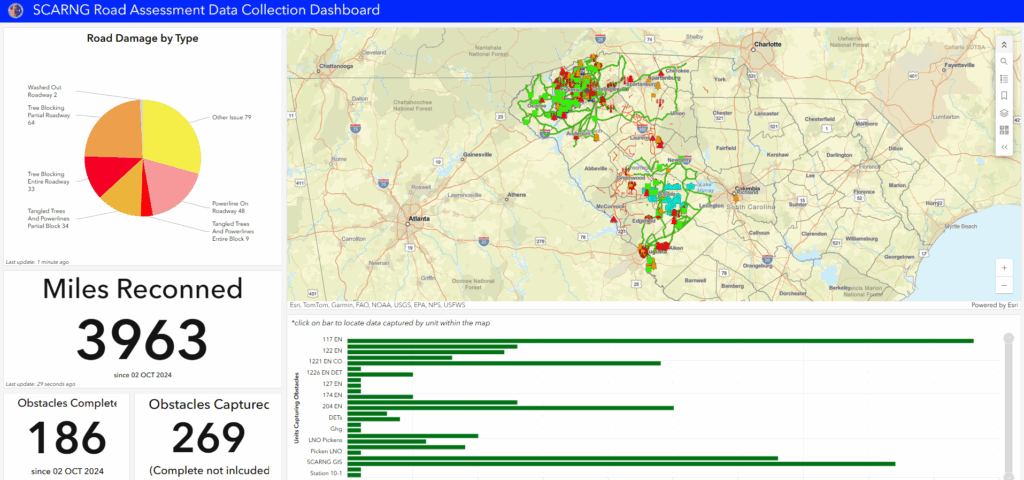
As the focus shifted from immediate response to recovery, thinking spatially continued to play a role in tracking reconstitution of critical infrastructure including damage to roads, bridges, power lines, and water systems. ArcGIS Online was used as a foundational planning tool for the Pioneer Brigade to partner with local officials in mapping the damage and prioritizing repairs – thereby decreasing redundant tasks and maximizing limited resources. Planning for and progress of vegetative-debris removal was monitored through interactive dashboard visualizations, which gave local and county emergency managers real-time visibility into ongoing efforts and into forecasting resource requirements and available capacity.
“By using GIS, the scope of the problem was clarified within 48 hours, and a clear picture of Helene’s impact began to take shape. We were able to combine geospatial data from all levels of government to develop an effective response plan.” Christy Jacobs, South Carolina State GIS Coordinator
Enhanced Coordination and Recovery in South Carolina
Following Hurricane Helene, GIS was invaluable in the Upstate of South Carolina; its use allowed seamless data sharing between SCNG and county Emergency Operations Centers (EOCs).
Counties that activated their EOC included GIS staff who leveraged a cross section of datasets to elevate situational awareness. The partnering county agencies were able to use SCNG apps and real-time data from the National Guard’s field applications. These tools provided instant, real-time status of road closures and vegetative debris-management efforts. Having this information allowed county leadership the time to take a step back, assess current needs, and begin planning longer term recovery efforts.
“In the chaos of post-storm recovery, information is submitted in many forms from spreadsheets, handwritten notes, phone calls, and verbal reports, as examples. Using common geospatial data allows efficiency in overall mission planning,” said Jacobs.
County-level EOC staff were able to integrate multiple sources of real-time data, thus allowing them to rapidly make updates to public-facing map services through ArcGIS Pro. Utilizing a geospatial approach 1) reduced the overall time analysts spent transcribing information from first responders and SCNG units 2) allowed time for meaningful analysis and 3) provided residents with faster updates through dashboards and web applications hosted by county EOCs in tandem with SCNG’s tools and resources. This approach also fostered a common operating picture that was vital in determining priorities across multiple programs as efforts began transitioning from response to recovery.
“Thanks to their efforts, we were able to integrate real-time field intelligence and share that information on-screen to support decision making inside the County’s EOC. Collectively the team was able to communicate spatially, which was vital in determining priorities across multiple programs supporting field efforts throughout the jurisdiction.” – said Michael Herzberger, GISP, CFM, Deputy Director, South Carolina Office of Regulatory Staff – Broadband Office
Lessons Learned from Hurricane Helene
Hurricane Helene reinforced the importance of stakeholders working together to understand available tools and resources. Interagency collaboration, through ArcGIS tools, streamlined decision making when it mattered most. For local and county emergency managers, the ability to access and utilize ArcGIS data ensured that hurricane-recovery efforts were well-informed and effectively executed.
While SCNG leadership has utilized GIS tools for years in response-and-recovery planning, the real breakthrough experienced during Hurricane Helene came from people using the technology in real-time to develop situational understanding. Using GIS allowed us to engage and interact using the common understanding provided by geospatial data. We were able to work effectively across agencies ranging from local agencies to the Governor’s Office. Building trust, establishing open communication, and promoting effective data sharing across agencies enabled SCNG to carry out its mission — innovating in ways that were both timely and highly relevant to the immediate needs of counties across the state.
Hurricane Helene impacted more than South Carolina. Residents in North Carolina, Georgia, and Tennessee all experienced devastating effects from this storm. Replicating the techniques discussed in this article can benefit disaster-recovery efforts in every state with some adaptation. The SCNG will continue to use the ArcGIS tools and methods of planning and coordinating ahead of future storms.
“As hurricanes continue to threaten South Carolina, innovating ways to leverage technology will remain a critical component of disaster response and resilience planning. The SCNG is always ready and will continue to seek out ways to collaborate in support of the residents of the Palmetto State.”– said Colonel William Matheny, 117th Engineer Brigade, South Carolina National Guard
The views expressed in this article are those of the author and do not reflect the official policy or position of the Department of Defense, the National Guard Bureau, the South Carolina National Guard, or the South Carolina Office of Regulatory Staff – Broadband Office.