I was delighted when our local trivia last week included the question “What year was the first Earth Day celebrated?” The question wasn’t even finished by the time I had the answer written down: 1970! It was my greatest contribution to the team that night.
Maybe it’s that I just got home from a fantastic biodiversity conference, or snuck away from the desk for an epic hike, or the launch of conservation.gov lighting up my social media feeds… but I’m feeling super optimistic this Earth Day! But I shouldn’t discount my optimism as just a series of amazing coincidences. I think about what was happening in 1970 to birth the first Earth Day? What was is its legacy, and how does that compare and contrast to 2024?
Twinning: A Compare and Contrast of 1970 and 2024
The decades leading up to the first Earth Day were rife with environmental activism. The Jackson 5 were leading the Billboard Charts, and bellbottoms were the only cut you could purchase jeans in. Unbridled growth and lack of regulation were harming human health and destroying the environment. Smog was a top concern amongst urbanites, and the popularity of developing our coastlines was met with a significant wave of establishing the majority of our modern National Seashores. Rachel Carson’s Silent Spring was published, coalescing national outcry and leading to the eventual passage of foundational environmental laws by the Nixon Administration – an Administration that didn’t even run on an environmental platform!
The times we’re living in now may have a different soundtrack, but the vibe is similar. Even bellbottoms are popular again. Climate Change replaces national seashores and environmental regulation as the hot topic, and the social movement to urge action is robust. There’s many differences, too. This movement seems more diverse, for one. Climate Change isn’t just smog for urban-dwellers, increased cancer rates for populations exposed near certain facilities, or the loss of habitats in our back yards. Not to diminish those issues – they’re extremely important, but they were also easy to ignore if you weren’t directly impacted. Climate Change is an equal opportunity adversary. It’s threatening lives, disrupting supply chains, and wreaking havoc on economies and national securities. Everyone is impacted and everyone has a role to play, and policies are singing this song.
Luckily, the 1970’s not only birthed world-leading revolutionary environmental policies… it also birthed Esri.

The Dawn of GeoAI at a Critical Juncture
Esri’s campus in Redlands has a library. In addition to awesome map books and great cartographic material, it also includes binders from the very first Esri User Conferences. They were small enough then that we could fit the entire agenda (with full abstracts!) in a 1-inch binder. When I thumb through these, I am amazed… nothing has changed, and everything has changed.
Our first adopters were environmental professionals, and their missions were the same then as they are today. I think about this in the context of the John Snow Cholera Map as compared to the Johns Hopkins Covid 19 Dashboard. These both had the intent of mapping the spread of disease, but the technology now is significantly advanced, and the scale of its immediate impact was exponentially proportionate to the advancement of that technology. The mission was the same. The technology behind it was the differentiator. Enter: GeoAI.
At Esri, we define GeoAI as the application of artificial intelligence (AI) fused with geospatial data, science, and technology to accelerate real-world understanding of business opportunities, environmental impacts, and operational risks.
The environmental community has a long tradition of adopting innovative GIS technology early, and GeoAI is no different.
Exhibit A
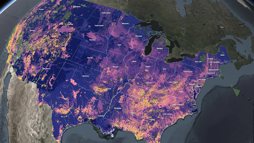
Another movement that was birthed in the 70’s? The establishment of NatureServe and the Heritage network across the United States and Canada. These Heritage networks began digitally collecting biodiversity observations using early GIS tools, but with any given state or province now having thousands of these observations to look after, it is impossible to track every single observation and know whether it still exists.
This is a huge problem, and with huge problems come huge opportunities. NatureServe’s latest Biodiversity Without Boundaries conference continued this early adoption tradition, with a plenary and numerous sessions focused on the immediate horizon of opportunity for applying GeoAI for the benefit of conservation; with existing work showcased by NatureServe and the US Fish and Wildlife Service!


Additionally, the explosion of “earth observation” coupled with GeoAI holds incredible promise, as showcased by Skytec LLC. Those thousands of biodiversity observations that are nearly impossible to monitor with classic field work? The State of Georgia was used in their demo, where Skytec was able to look at their biodiversity observations – some which hadn’t been monitored since the 70’s and 90’s and assess which ones have been impacted, and which may still be there – across the entire state, and on any kind of monitoring cadence you would like.
Minds. Were. Blown.


Capture this Moment of Opportunity
The increase in holistic environmental policies means new investment from new audiences is coming to the table. Corporations are asking questions about their own roles and responsibilities in sustainability, and policies are asking them to assess their impacts on biodiversity. Communities are establishing climate action plans and thinking about how they can enact a more resilient and sustainable future for themselves.
Maps accelerate that understanding, and this accelerates action. Environmental professionals are the experts on these topics, and we have a wealth of innovative GIS tools at our fingertips to help us bring our knowledge to these new audiences in simple and intuitive ways that don’t dilute the science.
How can we ensure we’re keeping our skills sharp? There’s a variety of pathways to get started – everything from pretrained deep-learning models you can use right away, all the way to integrating your GIS with other libraries to multiply your geospatial superpowers! You can explore these tutorials on our handy GeoAI page.
So for this Earth Day, I encourage you to make yourself a promise. A promise to the world to know that you have the knowledge of the “latest and greatest” tools, and that you’re thinking about how to use your new GeoAI skills to accelerate environmental and conservation actions!