ACCIONA Construction Australia is a Tier 1 infrastructure and tunneling contractor, recognized for delivering some of the most technically complex and environmentally sustainable engineering projects across Australia, spanning transport infrastructure, renewable energy, and water solutions.
ACCIONA Australia is at the forefront of Sydney’s most ambitious infrastructure expansion, delivering multibillion-dollar projects such as Sydney Metro West – Central Tunnelling Package, the Western Harbour Tunnel, and the WestConnex M4-M5 Link Tunnels. These projects span some of the most densely populated urban corridors in the country and demand unprecedented precision, coordination, and innovation.
To meet these demands, ACCIONA required a centralized, intelligent, and interoperable data environment capable of integrating vast amounts of geospatial and engineering data. This environment needed to serve a wide range of stakeholders—from field engineers to design consultants to project managers—while bridging the gap between design, construction, and operations.
Challenge
Despite operating in a digitally advanced environment, ACCIONA faced fragmented data workflows that hindered efficiency and increased project risk. Tunneling progress was historically tracked in static PDF shift reports, which lacked spatial context and made it difficult for nontechnical stakeholders to interpret performance. Property condition surveys were stored in sprawling Excel spreadsheets with no geographic visualization, complicating prioritization and follow-up. Environmental monitoring processes were inconsistent, and incidents such as unauthorized water discharges highlighted the urgent need for standardized digital compliance tools.
These disconnected systems created version control issues, coordination gaps, and delays in decision-making. They also made it harder to optimize resources, track progress against plans, and meet growing demands for transparency, sustainability, and efficiency.
Solution
ACCIONA implemented a comprehensive ArcGIS infrastructure across its tunneling and infrastructure portfolio, making GIS a foundational element of its common data environment. This transformation was not simply a digitization of existing workflows but a complete rethinking of how projects were delivered.
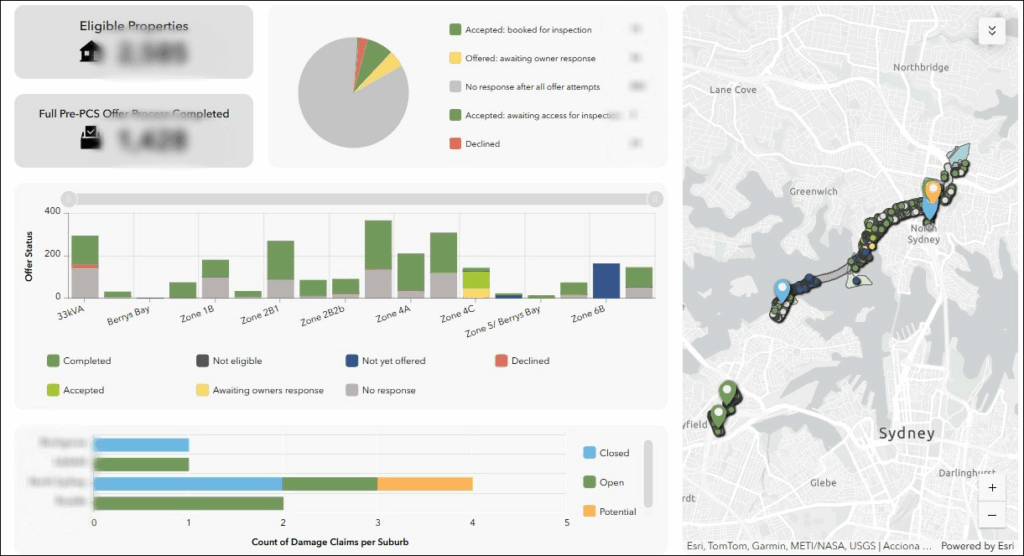
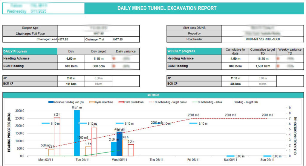
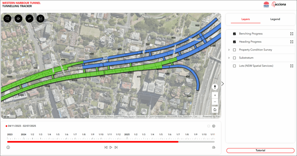
For tunnel excavation tracking, ACCIONA replaced static shift reports with a time-enabled dashboard built using ArcGIS linear referencing. This allowed excavation progress to be visualized in real time, showing tunneling machine performance, geotechnical conditions, and rate of advance in an intuitive and actionable format. Property condition surveys were migrated from spreadsheets into a centralized and interactive map-driven tracker, enabling teams to visualize inspection status for properties within 50 meters of tunnel alignment, identify trends, and coordinate follow-up actions more effectively.
Environmental accountability was strengthened through the deployment of ArcGIS Survey123, which standardized quality inspections, asset inspections, field checklists, and commissioning processes.
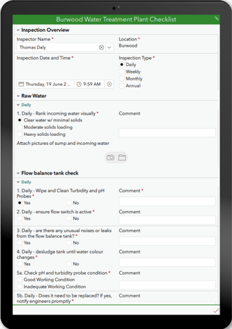
This improved compliance, enhanced data accuracy, and enabled proactive monitoring to prevent future incidents. By embedding ArcGIS into its workflows, ACCIONA empowered engineers, planners, and managers with live, geospatially contextualized project information. Collaboration was enhanced through map-based dashboards, mobile field access, and seamless data sharing between contractors, consultants, and clients. Environmental and community datasets were incorporated earlier in the design process, supporting sustainability and resilience planning from the outset.
Results
The integration of ArcGIS into ACCIONA’s operations has delivered significant and measurable benefits. Planning efficiency has improved through faster route and alignment analysis based on real-time spatial constraints. Coordination across teams became more effective, reducing rework and miscommunication. Decision-making was enhanced, with leadership able to act on actionable insights grounded in location intelligence. Sustainability outcomes improved as environmental datasets were integrated earlier in the design process, leading to better results for both construction and community impact.
Excavation tracking, site coordination, and data transparency have all advanced considerably. Stakeholder communication is now supported by accessible, real-time dashboards, while mobile field teams operate with tools that reduce errors, improve efficiency, and ensure compliance. Most importantly, GIS has evolved from a support function into a core pillar of project delivery, influencing everything from tunneling operations to environmental management and long-term asset planning.
By making GIS a strategic pillar of project delivery, ACCIONA has set a new benchmark for efficiency, transparency, and innovation in the global AEC industry. The integration of ArcGIS into its common data environment has unified data, streamlined collaboration, and ensured that every stakeholder operates from a single source of truth. This transformation has accelerated project timelines, reduced operational risks, and improved community and environmental outcomes—proving that spatial awareness, when turned into strategic insight, can redefine what is possible in modern infrastructure delivery.
Learn more about location intelligence for AEC:
GIS for Architecture, Engineering, and Construction.
Stay Connected with Esri’s AEC Team:
Subscribe to the AEC industry newsletter “Esri News for AEC”.