
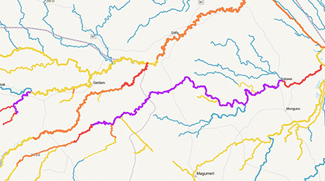
Streamflow forecast services and apps
Discover how Esri’s Living Atlas of the World and the Streamflow Viewer Instant App can help you forecast and share streamflow information.

Discover new insights, innovative best practices, and the latest advancements in GIS technology.

| Date | Event | Location |
|---|---|---|
| March 8–9, 2026 | Esri Partner Conference | Palm Springs, CA |
| April 15–17, 2026 | Esri International Infrastructure Management & GIS Conference | Frankfurt, Germany |
| July 13–17, 2026 | Esri User Conference | San Diego, CA |
| October 27–29, 2026 | Esri Infrastructure Management & GIS Conference | Palm Springs, CA |
| Date | Event | Location |
|---|---|---|
| May 18–20, 2026 | AWRA Geospatial Water Technology Conference | Niagara Falls, NY |
| May 31–June 4, 2026 | Assoc. of State Floodplain Managers Conference (ASFPM) | Milwaukee, WI |
| June 8–12, 2026 | Florida Floodplain Managers Association Annual Conference | Orlando, FL |
| September 8–10, 2026 | Floodplain Management Association Annual Conference (FMAA) | Long Beach, CA |
| November 9–11, 2026 | American Water Resources Association (AWRA) Annual Conference | Philadelphia, PA |
Streamflow forecast services and apps

Advanced WIM Workflows
Flood Simulation Capabilities in ArcGIS Pro

Elevation-Driven Hydro Feature Extraction

Arc Hydro: Analytics for Water Resources

Arc Hydro in Action
Getting Started with Arc Hydro