Cumbria, England, a rural northwestern county, is home to Garsdale Design, Ltd., an architectural, planning, and urban design firm housed in a converted countryside barn. Garsdale Design’s address may be remote, but the business boasts a global reach, with projects spanning from its backyard to locales as exotic as the Middle East.
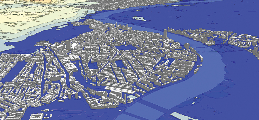
With substantial experience in 3D visualization and a variety of other GIS mapping services over the years, Garsdale Design continues to look for cutting-edge technologies to set its services apart. A smart 3D city model, featuring augmented data and more accurate buildings, proved to be the answer. The company targeted London, England—an internationally prominent metropolis steeped in history, commerce, and finance—for the project. An iconic city rich in old-world style coupled with architecturally progressive modern design made it the perfect showcase for precision geometry and adaptive modeling. Garsdale Design opted to offer its London clients an advanced, enterprise-level, 3D turnkey solution.

Geodesign veteran Elliot Hartley, a Garsdale Design director, focuses on the use of 3D urban modeling technologies. When researching the London project, Hartley explored ways to speed the workflow while improving the quality of 3D buildings and the information they contained. He also wanted the flexibility to bring 2D and 3D data into the model.
Hartley ultimately turned to Esri Silver Tier Partner CyberCity 3D, Inc., of El Segundo, California, a leading geospatial modeling company specializing in precise 3D city models (up to six inches accurate) that include an array of attributes, such as roof, facade, entity, and solar roof measurements. The company’s patented modeling technology utilizes stereo imagery to extract point clouds, providing the source data to produce models. These models can be converted into Esri CityEngine models, streamlining the workflow. [CityEngine is the stand-alone software product that transforms 2D GIS data into smart 3D city models.] This sealed the deal, as Hartley works extensively with and offers training in Esri products.
“These technologies are transformational,” says Hartley. “They’ve enabled us to make dramatic time savings while allowing us to communicate stories and information by combining 2D and 3D data from a variety of sources. For our business, it’s raised our ambitions, so we are inspired to reevaluate processes we took for granted.”
Before moving forward, a challenge confronted the project: securing the aerial imagery necessary to build London 3D. Vertex Modelling, centering on high-precision 3D models and headquartered in London, provided the stereo imagery and camera files needed for the original London 3D launch.
Upon obtaining the imagery in May 2013, CyberCity 3D got in production mode, starting with a four-square-kilometer “beta test” area south of Buckingham Palace. Since the model was being designed for England, the buildings were aligned using the British National Grid projection. Visualizing the 3D buildings in CityEngine was the next step.
The London model is optimized for integration into CityEngine. Once there, it can be modified as needed and exported as web scenes for viewing on a modern web browser without requiring an additional plug-in. In addition, the model works seamlessly, not only in CityEngine but also in ArcGIS and most other commercial formats and platforms.
As Garsdale Design worked with its new partner to build the London model, concentrating on the London City Centre, the company faced a key challenge: could the complete model of this dense, highly detailed area be surfaced in one CityEngine visualization scene? The answer? A resounding yes.
Soon Esri (UK) Ltd. joined the project. Sales in the insurance and facilities management arenas immediately resulted from that strategic partnership.
The London 3D city model lends itself to a variety of applications, especially in the arena of geodesign. Innovative solutions sit at Esri users’ fingertips, and the data the model provides enhances projects involving urban planning, visualization, solar evaluations, urban analysis, line-of-sight, shadow analysis/right-to-light, floor modeling, and real estate analytics. This extensive GIS information availability leads to faster workflows, better communication of complex proposals, and ease of data distribution via web services.
The build-out of the London model continues—extending out from the City Centre—with Garsdale Design now partnering with CyberCity 3D to market it through future cloud services. To date, the model encompasses more than 13.7 square kilometers and 5,700 structures. As the model grows, the interest does too.
“London’s City Centre and the city in general are undoubtedly one of the most popular areas in the world, making it a perfect place to create a 3D model,” says CyberCity’s CEO, Kevin DeVito. “The visualization, analytical, and planning information gleaned from this expanding model will undoubtedly influence projects defining the future of this legendary city.”
For more information, contact Elliot Hartley, director of Garsdale Design Limited, and Kevin DeVito, CEO, CyberCity 3D, Inc..

