Tech Time
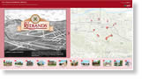
One way to build an Esri Story Map Tour app is to use a spreadsheet (CSV file) with the locations of the photos you want to use, the title and description of each tour stop, and other information. Read the blog. View the Treasures of Redlands, California, Story Map Tour app.
-
Esri's Jeff Shaner and Craig Gillgrass show you how to use Workforce for ArcGIS to plan and assign fieldwork, update the status of assignments, and much more. View the technical workshop online.
-
Seventeen communities have contributed new map layers to Esri's online basemaps through the Community Maps Program. The additions include Corona, California, and Blue Springs, Missouri.
See the contributions.
Read the blog.
-
In this new Learn ArcGIS lesson, build skills in administering an ArcGIS organization, designing a home page, sharing content, creating groups, and more. Take the ArcGIS Online lesson.
Maps & More
-
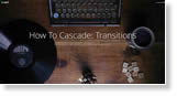
Learn how to select the right transition effect between views in the Esri Story Map Cascade app. The choices include fade, fade slow, swipe vertical, swipe horizontal, and none. Read the article.
-
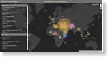
Using crowdsourced data from Wikipedia, the Esri Story Maps team worked with PeaceTech Lab to map the location of worldwide terrorist attacks. View the story map.

-
Data Appliance 6.3 for ArcGIS is now available. It plugs into your internal, secure network to deliver preloaded imagery, basemaps, and reference layers. Order today.
The Last Word
-
The ArcGIS Online US School Competition 2017 challenges students in grades 4–12 to analyze, interpret, and present data about their states by using ArcGIS Online presentations, web apps, or story maps.
Learn how your school can compete.
Read the blog.
-
Esri has pledged to support a European Commission initiative to boost digital skills in Europe. The company will offer free access to the ArcGIS Online platform to 300 primary, secondary, and vocational schools in 10 European Union nations by the end of 2017. Read the blog.