Tech Time
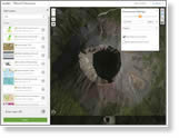
Use the scene viewer in ArcGIS Online to create 3D web scenes that show off natural wonders such as the Grand Canyon and Mount Vesuvius. Watch the video. Free ArcGIS Online trial.
-
Esri’s next-generation hillshade is the Multi-Directional Hillshade image service, inspired by the late Swiss cartographer Eduard Imhof. Read the article.
-
You can design bike lanes using the new Complete Streets in Esri CityEngine and then visualize the changes in 3D. Read the article in peopleforbikes. Watch the video.
-
ArcGIS Online offers imagery from several sources such as Landsat 8, which you can use in your maps and apps. Esri’s Deane Kensok walks you through how to access the images. Read the blog.
Maps & More
-
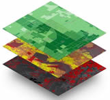
Add global demographic and spending data to your analyses. The data is available via ArcGIS Online and apps such as Esri Maps for Office, Esri Business Analyst Online, and Esri Community Analyst. Check variables by country. Get the data.
-
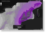
Worried that another Snowmageddon will strike? This snowfall forecast map will prepare people for what's next, snow wise, across the United States. View the map. Watch the video from Boston.
-
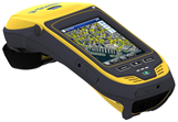
GeoCollector is a high-accuracy data collection solution for ArcPad or ArcGIS for Windows Mobile and includes Trimble’s Geo 7X handheld. Order today.
The Last Word
-
Use a move to SAP as a reason to embed live maps and location analytics directly into that system to improve workflows, be more productive, and make better decisions. Read the blog.
-
Do utilities have enough spatial intelligence to figure out what sparked an outage and the location of the problem? Read the blog.