Technical Talk
-
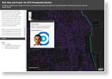
There are several different ways to map an election, including using a dasymetric dot density map. Read Esri senior cartographer Ken Field's blog and learn how one was created for the 2012 US presidential election. Field will explain his technique at the Esri UC.
-
Join the ArcGIS beta community and take ArcGIS Runtime SDK for Mac OS X for a spin. Get started.
-
Change your color ramp in four clicks. Read the tip.
-
Develop a Winning App
The clock is ticking, but there's still time to submit your app in the User Software Applications Fair at the Esri UC.
-
Find out how to migrate computer-assisted design (CAD) data to a geodatabase and download the latest ArcGIS for AutoCAD plug-in. Learn more.
-
See what's new in this latest ArcGIS 10.1 for Desktop add-in, which lets users play live streams of video or video files in a map. Read the blog.
-
Filter, perform analysis, and build a web map app using ArcGIS Online. Read this tip.
-
ArcGIS for Developers gives you what you need to add geo to your apps using Esri's cloud services. Get a 30-day free trial to ArcGIS Online.
Et cetera
-
Begin learning how to create 3D cities at Creating Smart 3D City Models with Esri CityEngine, a live training seminar on June 27, 2013.
-
See what you can do with CityEngine and its web viewer and slide tool. Get a free software trial, too.
-
See what's new such as support for class.on() style events for the map, layers, and tasks. Read the blog.
-
Desktop, Developer, and Enterprise exams for ArcGIS 10.1 are available at any Pearson Vue testing center worldwide. Learn more about the Esri Technical Certification Program.
-
Esri president Jack Dangermond's vision for a modern atlas depends on geographic knowledge from you. Read the blog.
-
-
Endpoints
-
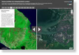
Compare 1990 Landsat satellite images to recent true-color imagery of places such as Mount Kilimanjaro, Tanzania; Columbia Glacier, Alaska; and Palm Springs, California. What types of change do you detect?

-
Gain experience with spatial analysis methods, including location analysis, change over time, and geographic distribution, with GIS Tutorial 2: Spatial Analysis Workbook. It has been updated for ArcGIS 10.1 for Desktop. Buy the book.
-
Esri offers cost-effective solutions to US customers who want to configure or upgrade their GIS. Esri's server, desktop, mobile, and data products are prepackaged with ArcGIS. Search for a hardware solution.