The Headlines
-
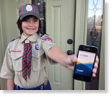
Joshua Perry, an intrepid Cub Scout and budding GIS user, created a web map to track his popcorn and pretzel sales orders using both ArcGIS Online and the Collector for ArcGIS app. Read how he did this, with a little help from his dad. Read the article.

-
You can find geospatial apps and data in the ArcGIS Marketplace. Take a closer look at three apps you can find there, including one that lets you contribute information to a common map. Read the article.
-
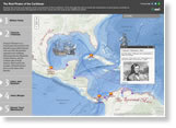
Which pirates preyed upon and plundered ships and ports in the Caribbean and Central and South America? View the Esri story map The Real Pirates of the Caribbean to learn about pirates such as Calico Jack Rackham and Edward Teach, a.k.a. Blackbeard. See the Spanish version of the story map.
News Bytes
-
You get your news, videos, and other information online. Now the web is also becoming the go-to place to create maps and apps. Read this article to learn about Esri's vision for ArcGIS as a cloud-based, online platform.
-
India is creating a national GIS platform that will help decision makers tackle social, health, and economic issues. Read the article.
-
The next version of the Esri Ocean Basemap will separate the basemap's annotation into a reference layer. Read this blog for details and see the beta version.
-
The Esri president receives the 2013 Champions of the Earth Award at a United Nations ceremony in New York. Read the article.
-
The Geospatial Information Infrastructure (GII) supplies geospatial data and application services for United States Department of Homeland Security missions. Read the article.
-
Though the worst seems over, New South Wales, Australia, continues to cope with wildfires. View the Australian Wildfires Map from Esri to see the locations of wildfires and warnings.
Centerpoints

-
Want to find innovative solutions that incorporate geodesign to plan sustainable and resilient cities? Sign up for the Geodesign Summit, January 29–30, 2014.

-
Find out how easy it is to use ArcGIS Online to share data collected with ArcPad. You can make web maps to share in ArcGIS apps that run on iPhones, Android smartphones, Windows Phones, and a variety of tablets. Watch the video.

-
Esri education manager Joseph Kerski blogs for Green 360, a careers website for high school and college students. As a Green Guru, he writes about the use of geospatial technologies in green jobs in fields such as recycling, renewable energy, and pollution reduction. Read the article.