Fall 2003
Fall 2003 |
|||||||
|
|
|||||||
Geospatial One-Stop and Hurricane Isabel
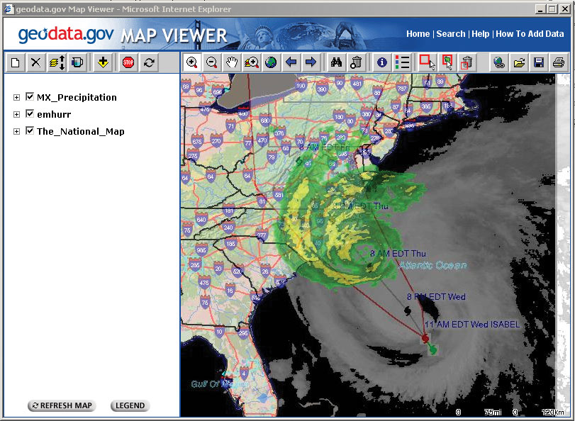
Riders on the Storm |
|||
|
By Hank Garie, Executive Director, Geospatial One-Stop
Geospatial One-Stop has adopted and promoted a simple vision: to support decision making by providing easier, faster, and less expensive access to geospatial information for government officials and citizens. The centerpiece of the Geospatial One-Stop strategy is the portal (www.geodata.gov), designed to facilitate publishing and searching of metadata and enable viewing of live Web mapping services (see "Geospatial One-Stop Portal Is Key to President's E-Government Strategy" in the Summer 2003 issue of ArcNews for background information). Can the Geospatial One-Stop portal deliver on the promise to support decision making? The first opportunity to test the premise arrived on September 16, 2003, as Hurricane Isabel approached the outerbanks of North Carolina. This article offers some observations and preliminary lessons learned from the experience. Events unfolded something like this. The annual conference of the National States Geographic Information Council was underway in Nashville, Tennessee, when it became apparent that Hurricane Isabel's track would impact the East Coast, potentially affecting 50 million people. More than 200 members of the geospatial community from across the nation were gathered in one place when Geospatial One-Stop posed the question: "What do you think we can organize by working together through geodata.gov to support the response to Isabel?" The partnering network began, and over the next 24 hours contacts were made back home to federal, state, county, and private sector organizations to canvas existing map services relevant to the hurricane planning and response. Esri staff, who provide hosting services and development support for the current geodata.gov portal gathered URLs supplied from contributing partner organizations and worked tirelessly to organize the services, maps, and links to relevant Web sites into a new portal channel-Hurricane Isabel. By the time the storm made landfall on September 18, 2003, the site was in production with more than a dozen services available through Geospatial One-Stop. In less than 48 hours the geospatial community responded with useful, real-time services based on data sharing. Participating government organizations included federal agencies (Geospatial One-Stop/Federal Geographic Data Committee, National Oceanic and Atmospheric Administration, National Aeronautics and Space Administration, United States Geological Survey, Department of Homeland Security, Housing and Urban Development, and the Bureau of the Census) and states (Delaware, New Jersey, North Carolina, and Pennsylvania) that cooperated with local counties. Private contributing partners included several news services, Esri, and Meteorlogix (who offered real-time weather service). Users of the portal could access storm tracking, modeling, and river condition information from the National Weather Service, satellite images, and regional and local live mapping services as well as news alerts and links to disaster planning Web sites. The integrating power of geodata.gov was apparent through the availability of the National Map as a basemap option and the ability to overlay real-time precipitation and weather data (updated every 10 minutes) through the map services made available by Meteorlogix. Lessons Learned
Next StepsThe experience with Hurricane Isabel proved the utility of Geospatial One-Stop as a source for geospatial information in support of a natural disaster. More important, it is apparent that the geodata.gov portal can potentially support all kinds of activities and decisions. The limiting factor is the amount and quality of mapping services and data sets that are searchable through the portal. The geodata.gov portal needs to be populated aggressively with metadata describing mapping services and GIS data sets if we as a community are to fully experience its value. Become a publisher! Register your GIS data and Web services now at www.geodata.gov. For more information, contact Hank Garie, Geospatial One-Stop (tel.: 703-648-5569, fax: 703-648-5755, e-mail: hgarie@usgs.gov). See also "2003 Annual Esri User Conference Honors GIS Professionals". |