Fall 2005
Fall 2005 |
|||||||
|
|
|||||||
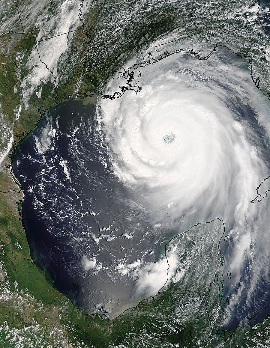
GIS Supports Hurricane Response |
|||||
Esri and many of its partners provided GIS software and services support to hundreds of organizations and agencies responding to hurricanes Katrina and Rita, including on-site technical support, temporary software licenses, hardware, large format printers, Web services, and more. Says Greg Tune, lead program manager for disaster assessment and GIS, American Red Cross, "GIS helped the Red Cross meet the challenges of providing food, clothing, shelter, emotional support programs, and other essential services in response to the hurricanes. The technology allowed us to work faster and smarter and gave us a means to do all types of analysis and mapping based on any needs requirement. This allowed us to be flexible enough to meet all types of requests." (See "American Red Cross Uses GIS for Hurricanes Katrina and Rita Efforts" for more about the American Red Cross response efforts.) In addition, Esri worked with the URISA GISCorps network of GIS professionals for volunteer services and set up a Web page to serve as a single source of information for various organizations and communities, as well as for Esri Business Partners that offered assistance. "The efforts of GIS volunteers have been tremendous, and we're very proud of the way these people went above and beyond to help wherever possible," says Shoreh Elhami, GISCorps cofounder and chairperson. "We at URISA sent a call for volunteers and the response was overwhelming. Hundreds of GIS professionals offered to help. Their work was invaluable and it made us proud to be a part of this effort." (See "GIS Volunteers Help in Mississippi's Hurricane Katrina Response" for more about URISA's GISCorps efforts.) Esri supported organizations including the Federal Emergency Management Agency (FEMA), U.S. Army Corps of Engineers, Department of Homeland Security, state/local first responders and Emergency Operations Centers, Salvation Army, utility companies, Environmental Protection Agency, National Oceanic and Atmospheric Administration, pipeline and oil companies, Department of Health and Human Services, United States Postal Service, and numerous customers and Esri Business Partners that were displaced by the storms. GIS Used in Hurricanes Katrina and Rita ResponseGIS technology helped deploy personnel, assign equipment, organize inventories, evacuate communities, model damage, and repair and restore infrastructure and crucial services. Search and rescue units used GIS mapping and analysis to locate populated centers and buildings where people might be located. Medical staff used GIS to set up shelters and provide medical care. Relief officials could better distribute food supplies. Public health staff could track potential outbreaks of disease. Public works departments could get water, sewer, and other city services up and running. Law enforcement could better monitor neighborhoods and provide safe zones. Mobile mapping was used to capture data in the field to assess damages and provide constant updates so staff could react quickly to shifting conditions. In addition, GIS software was used to generate thousands of maps for both "big picture" decision support and ground-level response. Satellite imagery, GPS coordinates, and other data sources were integrated and used for meeting specific user requests for various map products. Maps showed aid stations, damaged buildings and areas, communications networks, medical facilities, power outages and restorations, last known positions of missing persons, road closures, and safe water sources. They also aided in search and rescue operations, communicated information to government officials and the public, and helped the media map the news. "We were able to get up and running quickly in Mississippi, and it was an incredible collaboration of many agencies," says Talbot Brooks, director of the Center for Interdisciplinary Geospatial Technologies at Delta State University. "We supplied helicopters with GPS coordinates used to evacuate people from flooded homes. Hundreds of addresses and locations were translated into GPS coordinates for evacuation missions. This is just one example of GIS making a difference." (See "GIS Volunteers Help in Mississippi's Hurricane Katrina and Rita Response" for more about the center's response efforts.) Hurricane Response Web PortalEsri developed the Hurricane Response Web Portal (mentioned above) to assist various organizations and communities. Online mapping applications, hurricane advisories and response information, maps, satellite data, images, reports, and Web services are all available online. The Web site also contains links to other government and private sector Web sites, such as geodata.gov—Hurricanes Katrina and Rita Resources and Hurricane Community; FEMA's latest disaster declarations and maps of the designated areas; the U.S. Census Bureau Fast Facts on Areas Affected by Hurricanes Katrina and Rita, and more.
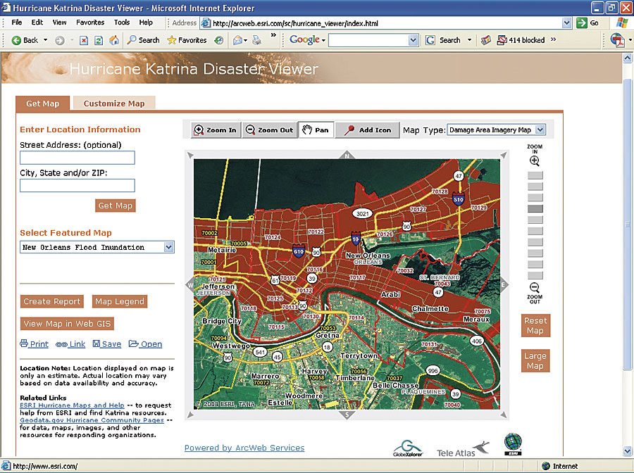
The Web site also includes the Hurricane Disaster Viewer, which allows people to view data and imagery for the affected areas and the southeastern United States. The viewer allows users to create customized maps and demographic reports, as well as locate an address or zoom to areas of interest and view areas declared "damaged" by FEMA, affected delivery areas for the U.S. Postal Service, postdisaster satellite imagery, population density, street maps, and much more. The application provides continuously updated information. In addition, the Business Analyst Online data reporting and mapping Web service is available free of charge to any economic development agency, urban and regional planning agency, trade association, or interested party for use in researching the impact of hurricanes Katrina and Rita. Professional ServicesEsri Professional Services were deployed throughout the region, providing support to local, state, and federal agencies throughout the affected area, including the FEMA Emergency Operations Centers in Baton Rouge, Louisiana, and Jackson, Mississippi. Esri staff provided database resources, desktop programming, information product automation, cartographic output, and overall project management support. Esri staff members began to be deployed immediately after Hurricane Katrina moved through the area, bringing their own computers, software, servers, large format printers, and mobile equipment. Esri provided additional support in response to Hurricane Rita prior to its reaching landfall. "The deployments happened from headquarters, as well as regional offices," says Craig Morgan, senior project manager, Esri. "We came in with everything we would need to set up shop. We're committed partners with these people—especially as they work in such difficult circumstances. The idea is to provide quick GIS information access and functionality and to be able to send or redeploy staff and resources in a flexible manner. We'll continue to serve for an extended period of time based on individual needs." Within hours of Hurricane Katrina's impact, Esri set up a multiuser, enterprise GIS environment at its headquarters in Redlands, California, for the state of Mississippi Emergency Operations Center to use as needed. This included multiuser geodatabase editing using ArcGIS running in a Citrix environment with ArcIMS accessing both value-added data and the latest ArcWeb Services orthophotography of the damaged areas. Professional Services also provided customized mobile GIS tools to allow quick data uploads into an enterprise geodatabase. As Hurricane Rita bore down on the Gulf Coast, Esri again began assisting emergency management teams; law enforcement; the federal government; and telecommunications, petroleum, and utility companies as they tried to lessen the impact of this hurricane. Professional Services provided support to municipalities, such as Harris County, Texas, as well as state agencies, such as the state of Louisiana Department of Environmental Quality and Department of Transportation. Assistance to federal agencies, such as the Department of Health and Human Services and Environmental Protection Agency, included the United States Geological Survey, GIS for the Gulf initiative to collect state, federal, and local data and publish it for use in the affected area by first responders. For more information, contact Craig Morgan, Esri Professional Services (e-mail: cmorgan@esri.com; tel.: 909-793-2853, ext. 1-1546). |