"Managing GIS"
A column from members of the Urban and Regional Information Systems Association
Geospatial Society, the GIS Profession, and URISA's GIS Management Institute
By Greg Babinski, GISP, Finance and Marketing Manager, King County GIS Center, URISA President
At around the time that this article is published, URISA will hold its 50th annual conference—GIS-Pro 2012—in Portland, Oregon. URISA—the Urban and Regional Information Systems Association—originated at a time when geospatial technology did not exist. Indeed, as Jack Dangermond recently reminisced (ArcNews, Summer 2012: "URISA at 50: An Interview with Jack Dangermond"), the history of GIS development is linked closely with URISA.
Past
The world of 50 years ago was much different, with a total population of less than half what it is today. Geography as an academic discipline was struggling for relevance, and GIS existed as neither a technology nor a profession. In the early 1960s, Professor Edgar Horwood from the University of Washington, Seattle, established a short course on computerized data mapping. A conference for his course alumni was held in 1963 and is considered the first URISA annual conference, even though the association was not formally organized until 1966.
For five decades, URISA has thrived with a basic formula for conference papers, articles, and courses: how to use new technology X plus spatial data Y for government business purpose Z.
As GIS software and other new technologies matured during the past decades, URISA helped the geospatial community develop and deliver value for society.
URISA's nearly 50 years of annual conference proceedings—as well as the URISA Journal, the GIS Professional, various books, quick study guides, workshops, and Exemplary Systems in Government (ESIG) Awards—document a half-century's development of intellectual capital. Hundreds of domains of knowledge have been created by URISA and documented in its publications.
Present
Today URISA remains a vital resource for the GIS community. In addition to GIS-Pro, URISA has a portfolio of specialty conferences (Addressing, Transit, CAMA, Public Health, Caribbean), 20 daylong workshops, and the weeklong GIS Leadership Academy. URISA has 29 chapters (including its first outside North America—in the UAE), as well as a formal affiliation with Surveying & Spatial Sciences Institute in Australia and New Zealand.
URISA has a proven track record of launching major new initiatives, including the GIS Certification Institute, the Coalition of Geospatial Organizations, and GISCorps.
Most recently, URISA was instrumental in the development of the US Department of Labor Geospatial Technology Competency Model and took the lead in developing the new Geospatial Management Competency Model. In parallel, URISA published the proposed Local Government GIS Capability Maturity Model (ArcNews, Winter 2010/2011: "URISA Proposes a GIS Capability Maturity Model").
URISA's GIS Management Institute: How will the GMI operate?
Future Geospatial Society, URISA, and the GIS Management Institute
The world is geospatially connected today in ways that it was not 50 years ago. Then, only one-third of the world's population was urban. Today, according to the UN, for the first time in world history, more than half the world's people live in cities; within the next 50 years, more than two-thirds will be urban. How will we fit two billion more people into livable cities? Urban is important, and today URISA is as relevant to the future as it ever was.
Technology also presents the geospatial community with new opportunities today. Cheap global air travel, shipping, and telephony, as well as the Internet, did not exist 50 years ago. The Cold War is long over, and the frontier of the developed, postindustrial world advances to provide more people with new economic opportunity. An international approach for the GIS profession is within reach.
Are there new frontiers in URISA's future? Three articles in the summer 2012 issue of ArcNews confirm a new direction that URISA is pursuing. David DiBiase's article ("Strengthening the GIS Profession") suggests that there is a moral imperative for GIS. Another article ("King County Documents ROI of GIS") proves that GIS provides significant financial benefit to society. Lastly, the Jack Dangermond interview (referred to above) suggests an important management focus for URISA's future.
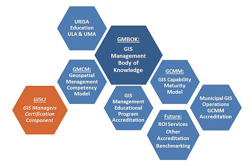
At the 2012 Esri International User Conference, URISA announced a new initiative to develop the GIS Management Institute (GMI). GMI will develop resources and services that focus on promoting the advancement of professional best practices and standards for the management of GIS operations.
GMI will build on resources that URISA has already developed, including the GIS Capability Maturity Model, the Geospatial Management Competency Model, the ESIG Awards, and the URISA Leadership Academy. A key component of the GIS Management Institute will be the development of the GIS Management Body of Knowledge (GMBOK).
The GIS Management Body of Knowledge will be the central unifying element of GMI. It will be used to refine the GIS Capability Maturity Model (GISCMM) and the Geospatial Management Competency Model (GMCM). The GMBOK will be a collection of peer-reviewed best practices and standards that can inform geospatial managers and operations to improve the effectiveness of their use of geospatial technology.
GMI will develop programs based on the GMBOK to accredit the capability and maturity of GIS operations against the GISCMM. It will also develop a program to accredit GIS management educational programs using the GMBOK and GMCM. URISA has agreed to work in cooperation with the GIS Certification Institute to advance the future certification of GIS managers.
The management of enterprise GIS operations requires knowledge, skills, and abilities that clearly set it apart from other management domains. GIS operations today are highly complex, are critical for effective agency services, and have been proved to deliver tremendous financial benefits. Central to GMI is the theory that as GIS operational maturity improves, return on investment from GIS increases.
GMI has been designated as a priority initiative. It will become an operational program of URISA. It is intended to be an international initiative with a global geospatial advisory council.
URISA does not intend to turn its back on the broad urban and regional information systems domains that have been important for the past 50 years. They are critical for helping to plan and build the highly urban society of the future. But URISA intends to serve society and strengthen the GIS profession by helping to promote the professional management and effective use of GIS into the future.
About the Author
Greg Babinski, MA, GISP, is the finance and marketing manager for King County GIS Center in Seattle, Washington, where he has worked since 1998. Previously, he worked for nine years as GIS mapping supervisor for the East Bay Municipal Utility District in Oakland, California. He holds a master's degree in geography from Wayne State University in Detroit, Michigan. Babinski is the president of URISA.
For more information, contact Greg Babinski, King County GIS Center (tel.: 206-263-3753, e-mail: greg.babinski@kingcounty.gov).