Spring 2002
Spring 2002 |
|||||||
|
|
|||||||
Both GIS Awareness and Esri Grow in 2001!
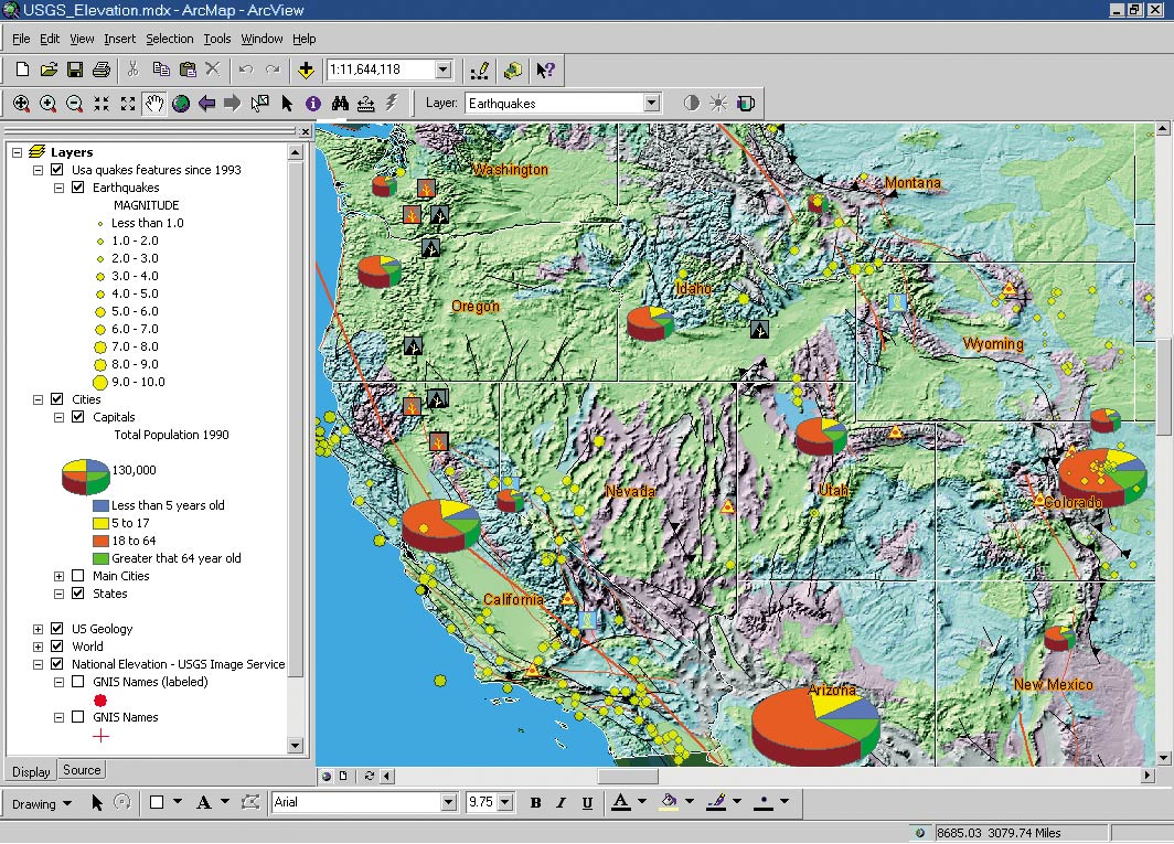
Taking the Pulse of the Planet with GIS |
|||||
Another highly successful year for Esri, 2001 was distinguished by the many victories and achievements of Esri's users and partners. It was a year in which GIS became easier, more standards-based, and more integrated. Geography is the framework for organizing our global knowledge, and GIS is the technology that will enable the dissemination of this information to all of society. "GIS will evolve into a kind of nervous system for our planet," says Jack Dangermond, president of Esri. "What we do and how we do it during the next few years will set the course for our world." With more than 120,000 users and one million licensed software seats, Esri is committed to advancing the use and capabilities of GIS technology and providing a model for building geography networks. In 2001, Esri made substantial inroads in achieving these goals. Here are some of the Esri software products that shipped in 2001: ArcGIS 8.1--Working to promote GIS as a tool for sharing information and facilitating cross-disciplinary, interorganizational cooperation, Esri has designed ArcGIS to be open, interoperable, and extensible. Built on a single common architecture, ArcGIS 8.1 includes updated versions of the well-known ArcView and ArcInfo software and introduces ArcEditor and the extensions ArcGIS Spatial Analyst, ArcGIS 3D Analyst, ArcGIS Geostatistical Analyst, ArcGIS StreetMap USA, ArcPress for ArcGIS, and MrSID Encoder for ArcGIS. A new feature of the 8.1 release is its ability to integrate data from Internet map services with local data sets, enabling ArcGIS users to search, view, and access map services through the Geography Network (www.geographynetwork.com), then integrate it through ArcGIS with local data layers. This release builds on the geodatabase model that was introduced in ArcInfo 8. It provides centralized storage of spatial data in a database management system. ArcGIS 8.1 also includes on-the-fly projection, exceptional map production, improved feature construction and editing tools, metadata creation and reporting, and an intuitive Windows user interface. www.esri.com/arcgis ArcGIS 8.1 Geostatistical Analyst--In this new extension for ArcGIS 8 desktop products, two powerful tools--geostatistics and GIS--combine to enable users to analyze spatial data, identify data anomalies, perform statistical estimation and optimal surface creation, and evaluate uncertainty in prediction surfaces. It is the first geostatistics software extension to include prediction, quantile, probability, prediction of standard errors, and standard error of indicators output maps within one interface. With the integration of more interpolation methods than any other GIS software, ArcGIS Geostatistical Analyst enables GIS users to assess the most accurate and optimal model for a specific problem. www.esri.com/geostatisticalanalyst
ArcView 8.1--The world's most popular desktop GIS had its most significant release in 2001. ArcView 8.1 maintains the base functionality of ArcView 3.x while adding an array of improvements from its completely new architecture. A catalog for browsing and managing data, on-the-fly coordinate and data projection, metadata creation, customization with built-in Visual Basic for Applications, new geographic editing tools, support for static annotation, and enhanced cartographic tools are new features included in this release. ArcView 8.1 functions as a stand-alone GIS and serves as the entry point to ArcGIS, Esri's integrated, scalable family of GIS software products. www.esri.com/arcview ArcIMS 3.1--The newest version of GIS for the Internet. ArcIMS 3.1 interacts with ArcGIS, enabling users to take advantage of ArcIMS as a data source in conjunction with other data types. The software supports code pages for all languages for shapefiles and database files and offers significant security enhancements. www.esri.com/arcims ArcIMS Route Server Extension--This ArcIMS 3.1 extension gives GIS users in the United States the ability to incorporate point-to-point driving directions and fast, accurate routing into Web sites built with ArcIMS 3.1. It also calculates optimal routes based on time and distance while accommodating multiple stops along a route (see ArcIMS 4 Offers Significant New Capabilities and Extensions). www.esri.com/arcims ArcIMS Site Starters--Esri's Internet mapping solution, ArcIMS, now includes templates to help developers build ArcIMS-enabled Web sites faster and more easily. ArcIMS Site Starterapplications are highly customizable templates that enable users to build simple, lightweight applications into ArcIMS-powered Web sites. The site starters are a set of Active Server Page applications that can be tailored to individual data sets. Each Site Starter application addresses a specific Business function, such as database search, and presents users with an intuitive, step-by-step path for generating maps and reports (see ArcIMS 4 Offers Significant New Capabilities and Extensions). www.esri.com/arcims ArcView Business Analyst 1.1a--Esri's award-winning desktop GIS solution for Business is a powerful tool for making better Business decisions and combines the full functionality of Esri's popular ArcView software with intuitive data analysis tools and a robust catalog of year 2000 Business, demographic, and household data for the United States. ArcView BusinessAnalyst 1.1a features an updated ArcView StreetMap, an enhanced geocoder from Sagent Technology, Inc., Seagate's Crystal Reports 7.0, and the enhanced ArcView GIS 3.2a. www.esri.com/businessanalyst BusinessMAP Travel Edition--A mapping tool for the Business traveler, BusinessMAP Travel Edition includes direct links from ACT!, GoldMine, Outlook, and Excel; reading capabilities for Access; and dBASE, text files, Dun & Bradstreet's database of 11 million Business listings, door-to-door driving directions, and route optimization for the entire United States. More than a travel planner, BusinessMAP Travel Edition has customizable toolbars and menu selections. Users can save maps and directions to their Palm organizers or print maps from day planner size to wall charts. www.esri.com/businessmap_travel ArcLogistics Route 3--In 2001, Esri shipped a major new release of its desktop routing and scheduling solution. Fully interactive, ArcLogistics Route 3 helps Businesses and organizations deliver goods or services more efficiently, reducing costs and improving customer service. The new version gives users a second-time option for service and allows them to set a grace period for an order to be serviced and still be considered on time. Orders can be prioritized, and ArcLogisticsRoute 3 has second-day routing capability. An improved architecture for customization and a new application framework are additional enhancements. www.esri.com/arclogisticsroute MapObjects 2.1--Esri's newest version of powerful, embeddable mapping and GIS components, MapObjects 2.1 offers support for ArcSDE 8.1, AutoCAD 2000 DWG files, and ActiveX Data Objects; image catalogs; the latest Esri projection engine; custom symbols for chart rendering; and a new run-time deployment utility for easier application distribution. The new version of MapObjects has built-in compatibility with Esri's ArcIMS Web connectivity middleware. www.esri.com/mapobjects ArcExplorer 3.1--Java Edition--The newest version of Esri's popular GIS data viewer is free and downloadable from Esri's www.esri.com/arcexplorer Web site. ArcExplorer is a lightweight data explorer for querying and browsing GIS data. The new edition enables quick and easy access to the Geography Network and has easily accessible transparency settings. With the new version, users can add ArcSDE 8.1 layers to their ArcExplorer projects, and ArcExplorer 3.1 is an excellent ArcIMS client. Creating Communities Around the GlobeMore than 11,000 GIS professionals filled the halls of the San Diego Convention Center in July 2001 to participate in the 21st Annual Esri International User Conference. The conference theme "Geography--Creating Communities" focused on GIS as a technology for creating communities among and within organizations. How these communities evolve, the technologies they implement, and the institutional mechanisms that support them were topics of discussions initiated by Dangermond during the conference's opening plenary session. Technical sessions, seminars, workshops, and software demonstrations covered many disciplines with topics such as conservation, crime analysis, global warming, defense, population analysis, and epidemiology and offered many opportunities for GIS users to exchange ideas and lay the foundations for their own geography networks. Dr. Michael Fay, the conference keynote speaker, who works for the New York City-based Wildlife Conservation Society, documented his 15-month Megatransect through a remote jungle corridor that included the Langou� Forest. During the trek, he systematically surveyed the area focusing on plantlife, wildlife, and the effects of human activity. Fay also made an appeal to save the Langou� Forest, a pristine area of more than 600,000 acres within the Congo jungle in Gabon. In a spontaneous gesture, conference attendees raised a few thousand dollars with the passing of a tote bag, but they wanted to do more, so Esri helped to organize a fund-raising effort to protect the Langou� Forest. The Web site--www.savethecongo.org--provides detailed information on the project and how to contribute. To date, more than $2 million has been contributed. We urge our users to help raise the $3.6 million needed to create one of the world's most important national parks. A New Vision for GIS Technology on the WebAs more and more people understand the value of spatial data for structuring organizations, solving problems, and communicating the broader context of issues through a visual language, the need for easy access to geographic information continues to rise. In 2001, Esri's Geography Network (www.geographynetwork.com) and its g.net architecture emerged as the first major implementation of Web services providing access to spatial data. "The g.net architecture is network-based, multiparticipatory, and collaborative and enables organizations to openly share and directly use GIS information from many distributed sources at the same time," says Dangermond. "It is my hope that GIS professionals will take this service, build networks for their communities, and expand the use of GIS throughout the world." The Geography Network adheres to industry-standard formats and technology and is a framework for building and launching a commercial data distribution mechanism on the Internet. Built using ArcIMS, the Geography Network is an open environment for hosting and viewing geographic data, maps, and services. It provides a direct link between the user and service providers offering maps, value-added data, and industry-specific applications and solutions. Several prominent data providers announced their participation in the Geography Network last year. Among the new participants are Meterologix, a leading provider of weather data and weather forecast services; ORBIMAGE, a global provider of satellite and aerial earth imagery products and services; Geographic Data Technology, provider of the Dynamap Streets and Address database; and the Pennsylvania Spatial Data Access program. In May 2001, the United Nations Environment Programme launched its Environment Network Web site, UNEP.Net, using the Geography Network portal and data published through the Geography Network. The U.S. Department of Agriculture (USDA) and Esri signed a sweeping purchase agreement for a departmentwide site license for Esri software. The agreement will enable the USDA to embark on an ambitious and far-reaching program and strengthen program delivery by extending the functionality of GIS throughout the entire organization, providing more efficient and timely services and trimming individual agency costs considerably. Representing a partnership between the Bureau of Land Management, the U.S. Department of Agriculture Forest Service, other agencies, and Esri, a new Web portal, GeoCommunicator, appears on the Geography Network as an information source focused on cadastral land records, parcel data, and land management activities. In addition, Esri is providing the Census Redistricting 2000 TIGER/Line data in ArcView shapefile format for download from the Geography Network. An A+ in GIS EducationEsri continues its commitment to building a global GIS workforce and now has more than 20,000 educational programs in K-12 schools. EdUC 2001, Esri's first independent conference for educators, was held just before the International User Conference in San Diego. More than 450 attendees gathered at the Convention Center to exchange ideas and concepts for the use of GIS in the classroom. More than 70,000 GIS professionals worldwide enrolled in Esri's instructor-led software classes in 2001. Esri software training is more accessible than ever, with classes available at regional offices, client sites, and international distributor locations around the world. In the United States and more than 50 other countries, Esri third party instructors now number more than 1,000. Ten new instructor-led courses on ArcGIS, ArcIMS, and ArcSDE were developed and taught in 2001. New courses and course updates are planned to support software releases in 2002. www.esri.com/training Esri's Virtual Campus continues to be a focus for GIS professionals and students--2001 enrollment grew to more than 122,000 members representing 178 countries. With 14 new courses, 33 courses in various disciplines are now available. Noteworthy courses include Planning for a GIS by Dr. Roger Tomlinson; Turning Data into Information, a companion Web course to the book Geographic Information Systems & Science, by Paul Longley, Michael Goodchild, David Maguire, and David Rhind; and Mapping for Health Care Professionals, by Zvia Segal Naphtali, Ph.D. Esri has granted free, unlimited access to Virtual Campus course subscriptions to Higher Education Site License holders worldwide and introduced free live training seminars to GIS professionals selecting Esri software training. Learn more about Esri Training and Education. There are now 29 titles in the Esri Press collection. Among the books released last year are Getting to Know ArcGIS Desktop, a self-study workbook; Planning Support Systems, a volume of edited papers by Richard Brail and Richard Klosterman; and Conservation Geography, and a collection of case studies by Charles Convis. Plans are in the works to publish books on ArcObjects, oceanography, Business, K-12 education, and the history of GIS. www.esri.com/esripress The third annual GIS Day event, held November 14, 2001, educated millions of children and adults around the world. Activities focused on illustrating the benefits of geography and the supporting role that GIS plays. More than 80 countries held GIS Day events along with the 50 United States. Strengthening PartnershipsEsri continues to expand its corporate relationships and Business Partner program. With the release of ArcGIS, all of Esri's core technology now contains Microsoft's COM-based components and can be customized with Microsoft's Visual Basic for Applications scripting language. Last year, Microsoft accepted Esri into its .NET Early Adopter Program as a key Independent Software Vendor. Esri will demonstrate early successes with .NET developer technologies. The DB2 Spatial Extender, jointly developed by Esri and IBM, enables the integration of geographic, map-based data with other data stored in DB2. IBM is also working with Esri to integrate MapObjects display capabilities into IBM commercial software. 2001 saw the launch of the Java Location Services Web site (www.jlocationservices.com) by Esri and Sun Microsystems, Inc., to promote the importance of Java and GIS technologies as foundations for successful location services. The Web portal provides users with a central location to access information about location services. In March, Esri announced a Business partnership with LineSoft Corporation, a leading producer of transmission and distribution engineering line design and optimization software. The joint venture provides utility customers with a high level of GIS/mapping and engineering design integration. The MapShop solution, developed by Esri and the Associated Press, the world's leading news organization, is an easy-to-use online mapping service that is helping to change the way consumers around the world view and interpret the news. The system of integrated components provides analytical mapping tools and data services to journalists, database editors, and graphics personnel. With users and partnerships growing globally, Esri is extending its outreach with more conferences, seminars, and user expos. The Europe, Middle East, and Africa 2001 User Conference took place in Lisbon, Portugal in October. More than 600 attendees participated in the four-day event. (See Belgium to Host 17th Annual Esri European User Conference and Sixth Annual Esri Middle East and Africa User Conference for information about the 2002 conferences.) Remembering 2001Esri and many of its users and partners received awards and recognition for their GIS work that has helped society in so many ways. Among these, Esri and the Center for the Analysis and Research of Spatial Information (CARSI) at Hunter College, the City University of New York, received commendations from the American Geographical Society (AGS) for meritorious service to New York City and the nation following the September 11 tragedy. AGS honored Esri for donating resources and key personnel to the recovery effort, specifically for helping to reconstruct the City's geographic information infrastructure. CARSI was cited for lending its technology and expertise to help City officials map the shifting Ground Zero terrain. |