|
For years electric companies have relied on GIS for efficient system operations but with advances in technology, they now find their GIS valuable for other projects from marketing analysis to land management. GIS integrated with corporate business systems helps utilities to develop new business strategies; broaden product and service offerings; improve marketing, sales, and customer service; streamline operations; increase productivity; and reduce costs.
| |
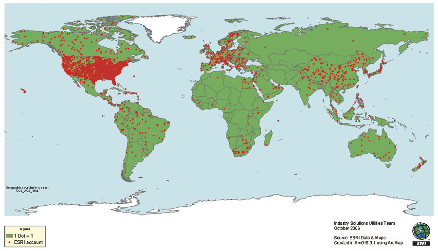
One dot equals one international Esri electric utility account. The dots are randomly displayed in the countries to maintain confidentiality. |
As evidenced by many worldwide success stories, Esri delivers the core enterprise technology platform, software products, and industry domain application business partners to help electric companies realize their vision. Here are a few examples of how power companies from around the world are using Esri GIS technology to manage their networks and integrate the spatial dimension in many of their daily business processes.
Europe
Austria
Energie Steiermark-Steweag provides networked services throughout the region of Styria, Austria. Steweag is a longtime user of Esri technology, using GIS for utility management, as well as vegetation and parcel management. One application can geocode parcels and owners along the length of a power line to streamline field operations. By using ArcIMS for its intranet, Steweag employees can access map data and integrated GIS applications on the Web.
The Czech Republic
CEZData, s.r.o., part of the CEZ Group, is the largest electric utility provider in central Europe, serving approximately seven million customers in the Czech Republic, Romania, and Bulgaria. CEZData is deploying the full suite of ArcGIS products in an open, scalable, and standards-based GIS architecture throughout the entire CEZ Group operation. The GIS will integrate with and leverage existing CEZ IT resources to meet a broad range of business and engineering needs now and in the future.
Germany
As one of Germany's largest energy suppliers, Energie Baden-Wurttemberg AG (EnBW) is implementing an integrated company-wide network for its geospatial data that is accessible to more than 1,700 users. The enterprise solution is based on ArcGIS and related software products. The system is used for technical area organization, technical plant management, and network control. SAP integration to support business processes is an integral part of all project phases.
Utility company EWR AG uses ArcGIS and complementary software for network data analysis, allowing the company to efficiently evaluate its asset and network data and use this information for corporate decision making. The company is integrating the GIS with the existing supervisory control and data acquisition (SCADA) system. In the future, local authorities and construction companies will have some access to the reporting capabilities of the GIS.
SWM Magdeburg (the public utility of Magdeburg) defined various GIS projects, the most important being integration with SAP, integrated planning, connection with network calculation systems, mobile GIS, redlining, and document management. SWM Magdeburg aims to integrate SAP and AED-SICAD's ArcFM UT as the main pillar of its corporate IT. Through this integration, the utility ensures that the data is kept up-to-date and consistent in both systems, yet both can be applied simultaneously through the bridging of SAP and GIS. All further network-related graphic applications in the utility are either replaced by the GIS or connected to it; therefore, all spatial data lies originally in the GIS. With the new utilities application from AED-SICAD, SWM Magdeburg has a corporate and highly integrated solution for all spatial processes.
| AED-SICAD, Bonn/Munich, Germany, is the leading GIS application provider in Europe, offering standard applications and tailor-made solutions for multiple industries. ArcFM UT is its solution for the electric utility industry. It combines the strengths of Esri technology, ArcGIS and Telvent Miner & Miner's ArcFM. The system is used for network documentation, outage management, maintenance, customer information, integration with SCADA, and planning. |
The public utility of V�lklingen, Germany, covers the community's electricity, gas, water, and district heating needs, thus providing a complete energy and water supply to the people and businesses from one single source. The company operates a comprehensive network infrastructure to cover the vast supply region along the French border. The Technical Planning Department uses ArcFM UT View with the Designer component for project planning purposes. Using ArcFM UT Web and the GIS portal based on ArcIMS, up to 20 additional staff members of the public utility can use geographic information in their daily work.
The Netherlands
The Dutch energy company DELTA uses GIS from Esri to optimize the quality and life cycle of its infrastructure and to manage its assets at lower cost. GIS helps DELTA rapidly identify affected areas of infrastructure during excavation work, utility breakdowns, and other maintenance projects. The solution for DELTA is based on the ArcFM UT product manufactured by Esri Business Partner AED-SICAD.
Sweden
In G�vle, Sweden, the distribution networks for electricity, heating, and fiber optics are all managed by the municipal energy company G�vle Energi using GIS. The company migrated away from its proprietary software, which was found to be unsuitable for managing the company's complex distribution grids. G�vle Energi turned to ArcGIS because it could coordinate information about various distribution networks. Another important feature is that the software is extendable. The company used a modular approach for implementation. Using ArcGIS makes it possible for the company to grow its GIS as the need arises.
Middle East
The Kingdom of Bahrain
The Ministry of Electricity & Water (MEW) in the Kingdom of Bahrain is implementing an enterprise GIS based on the ArcGIS software platform. The project will facilitate the timely and accurate capture, documentation, and distribution of network asset information to the entire MEW workforce.
Egypt
The GIS implementation at the North Delta Electricity Distribution Company in Egypt is designed to manage and monitor all medium-voltage electricity networks throughout the Nile delta. Built upon the ArcGIS platform, the system includes query, editing, reporting, and single line diagram modules. The GIS configuration is composed of ArcSDE, ArcInfo, and ArcView software.
Lebanon
Electricit� Du Liban (EDL), the state-run Lebanese electric utility, generates, transmits, and distributes electricity to more than one million customers throughout Lebanon. With the support of consulting engineering firm Khatib & Alami (K&A), the Esri distributor in Lebanon, EDL has successfully implemented its GIS based on Esri technology to model and manage its electrical system infrastructure in municipal Beirut—the Geographic Information Systems Electricity of Lebanon (GISEL) project.
United Arab Emirates
To help resolve its data management issues, the Federal Electricity and Water Authority (FEWA) in the United Arab Emirates is incorporating the company's legacy data including CAD drawings, facility records, photographs, and maintenance history information into its enterprise GIS. ArcGIS enhances the current technical maintenance and management of FEWA's electrical and water assets and optimizes resources in terms of time, personnel, and support.
Asia
India
Reliance Energy Ltd. (REL), India's leading integrated power company, uses enterprise-wide GIS to integrate its diverse information technology systems, such as SCADA; IS-U CCS (SAP's billing and customer care module); SAP R/3 (plant maintenance and materials management), outage management; and network analysis tools, such as CYME. Esri's ArcIMS Internet technology plays a pivotal role at REL in disseminating location, network, and attribute information stored in the utility's geographic database to thousands of its users based in Mumbai and Delhi. REL is planning to take GIS not only to its office staff but to its field staff, too, by providing laptops inside the mobile fault detect and locate vehicles.
South Korea
Korea Electric Power Corporation (KEPCO) is using its transmission and substation GIS (TGIS) to efficiently manage transmission lines and substation facilities nationwide. TGIS helps KEPCO manage the specification, history, and connection information of all transmission and substation facilities, which are overhead or underground. With its TGIS, built on ArcGIS, KEPCO maintains the base and thematic mapping and facility asset management, as well as map services, to be used in providing map content on business demand over its intranet.
The Philippines
The Tarlac Electric Cooperative, Inc. (TARELCO), in the Philippines used ArcGIS to build a comprehensive database of equipment, poles, distribution lines, and consumer members. The software helps the company keep track of the location and condition of its facilities and automate operations for asset management. It also is helpful for satisfying requirements of government regulatory agencies.
The National Transmission Corporation (TransCo) is responsible for electrical transmission for the country's National Power Corporation. TransCo is implementing an ArcGIS software-based assets management system to keep track of the location and condition of all facilities, devices, and structures. The GIS will also help meet the informational requirements of the government regulatory agencies, including the National Electrification Administration and the National Transmission Corporation.
The Americas
Bermuda
Bermuda Electric Light Company Limited (BELCO) is Bermuda's sole supplier of electricity, operating a generating plant and transmission and distribution systems throughout the Bermuda islands. BELCO is a longtime user of Esri ArcGIS software and Telvent's Miner & Miner (M&M) ArcFM Solution for asset management. BELCO chose this solution because it wanted to reduce the amount of redundant data entry by storing as much data in a single database repository as possible. In addition, BELCO wanted to have a more accurate representation of its facilities, including its secondary network, and to maintain the customer and facility data that resided in its outage management system.
Brazil
In South America, the Brazilian Companhia Paranaense de Energia (Copel) has been using GIS for years. An impressive use of its applications is for environmental preservation around existing hydroelectric power plants and transmission lines and the construction of reservoirs. Other applications are for environmental contingency planning, relocation of people living in affected areas, asset management, and water quality monitoring.
Canada
Chatham-Kent Hydro, a single-tier local Canadian government in southwestern Ontario, implemented ArcGIS and ArcFM to replace the legacy automated mapping/facilities management (AM/FM) system it operated at its utility divisions since 1998. The combined Esri and M&M technology provides a streamlined solution for spatial management of electric, water, and wastewater networks. The ArcGIS/ArcFM solution provides off-the-shelf technology that will extend existing functionality, allowing Chatham-Kent to further leverage GIS within its Hydro, Public Utilities, and Engineering departments. By consolidating its data management systems onto a single GIS platform, information sharing and access will improve across the organization. The benefits afforded to the utility divisions expedite the services provided to its customers.
Cura�ao (Netherlands Antilles)
Aqualectra, the water and electricity authority of Cura�ao, had its network digitized in CAD data format but needed an enterprise-wide solution to facilitate data sharing. ArcFM was implemented with interfaces to the existing customer information, work order management, outage management, and hydrological and electrical modeling systems. Esri's open platform guarantees access to the GIS from the desktop and the field.
Puerto Rico
The Puerto Rico Electric Power Authority (PREPA) is a public corporation and government agency that produces, transmits, and distributes nearly all the electric power used in Puerto Rico. PREPA's ArcGIS software-based system is providing support throughout the entire agency, particularly for the Engineering Directorate.
United States
The Bonneville Power Administration (BPA) is a government agency with the U.S. Department of Energy that serves 10 million people in the Pacific Northwest region of the country. BPA used Esri's development tools to design an online viewer that provides BPA employees access to spatial data about BPA's transmission lines. The transmission network viewer allows personnel to access and display asset data such as tower location, operating name of line, tower type, and the conductor elevation attachment point. The map displays a network representation, and the identifier tool indicates the assets on a specific tower. Users can search layers that contain data about roads and rivers, service area boundaries of cooperatives and public utility districts, landownership, and threatened and endangered species, plus any other data in the corporate geodatabase.
Alabama Power, operated by Southern Company (see main article "GIS Powers Electric Industry"), is located in the United States' high-risk hurricane region on the coast of the Gulf of Mexico. The company uses its GIS for its disaster plan. During hurricane season, Alabama Power's emergency response system goes to work. Its Esri GIS platform is integrated with OMS, SCADA, and customer information systems. The company replaced its PDF maps with on-the-fly geoprocessing. During a hurricane, traces and outage data are updated in real time. By working with a GIS map document file instead of snapshot PDFs, managers can use GIS to zoom in to data such as specific switch information.
Africa
South Africa
The South African government's electricity utility, Eskom Holdings Limited, provides more than
98 percent of South Africa's electricity and generates approximately 45 percent of the electricity used on the African continent. Eskom's Transmission Division's Transmission Spatial Information System (TxSIS) is built on Esri's ArcGIS software supporting GIS across the enterprise. TxSIS provides support for strategic planning, line fault investigations, and legal portfolio management. The geodatabase is managed with Esri's ArcSDE spatial database engine software. TxSIS includes intranet mapping services that are built with ArcIMS
software, which is used to distribute online maps that show the transmission network relative to its natural, physical, and legal environment, along with other technical transmission-related information.
More Information
For more information, visit www.esri.com/electricgas.
See also "GIS Powers Electric Industry" and "Power Cooperatives and Municipals in U.S. Are Better Equipped with GIS."
| Energy Currents is a free newsletter that provides an informative GIS perspective to the electric and gas community. It provides links to data resources, software tools, and announcements. Past issues of Energy Currents can be found at www.esri.com/ energycurrents. Any Esri publication can be subscribed to free of charge by visiting www.esri.com/subscribe. |
|