Fall 2004
Fall 2004 |
|||||||
|
|
|||||||
ArcGIS 9—A Complete Imaging Solution |
|
|
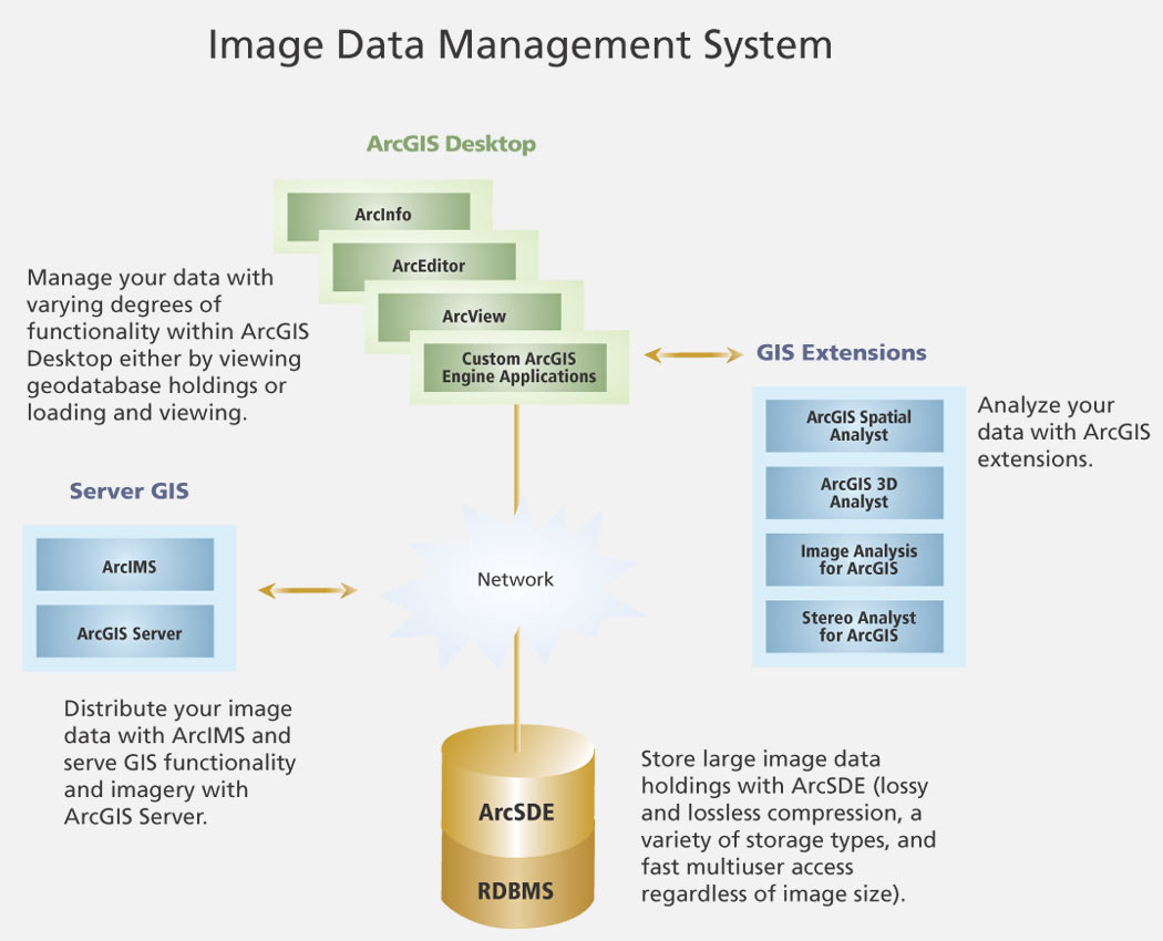
With the release of ArcGIS 9 this spring, ArcGIS users now have access to a complete suite of imaging solutions from Esri. The ability to manage, analyze, and serve imagery and other types ManageArcGIS Desktop (ArcInfo, ArcEditor, and ArcView) is used to manage the imagery data. It can also automatically create image footprints and publish metadata enabling users to quickly search large raster data collections based on any combination of geographic extent, content type, data format, or keyword. For users who need to merge all of their raster data sets into one continuous data layer, several methods of employing mosaics are available allowing users to create continuous multiterabyte raster mosaics. Both lossy and lossless raster compression types are available as well, allowing the user to match image quality and storage requirement needs. Custom applications can be built with ArcObjects to manage an enterprise raster repository in ways specific to an organization's needs. Many users have already learned that storing imagery data in ArcSDE is advantageous. Loading data into ArcSDE creates an environment where managing very large image sizes and data sets no longer poses problems. ArcSDE is a core component of Esri's enterprise geodatabase raster data management system, enabling organizations to store their raster data and the related metadata in commercial relational database management systems (IBM DB2, Informix, Microsoft SQL Server, and Oracle) for fast, online, multiuser access to raster data. AnalyzeExtensions to ArcGIS 9 make the analysis of data easy. Organizations that already have these tools can now leverage them to analyze raster or vector data. Using ArcGIS extensions ensures compatibility of file formats and does not require purchasing a third party product for optimized raster display or analysis. The result is a savings in time and money for the organization. The ArcGIS extensions that can be used for raster GIS modeling or image analysis are described below. ArcGIS Spatial Analyst—This extension provides analysis on all raster and vector formats supported by ArcGIS. It also adds a comprehensive set of advanced spatial modeling and analysis tools to ArcGIS Desktop. Using ArcGIS Spatial Analyst, users can perform a wide variety of GIS analysis tasks, such as digital elevation model-based surface analysis, hydrologic modeling, weighted overlay, and suitability modeling, as well as image processing tasks, such as filtering, classification, and generalization. The ArcGIS Spatial Analyst extension also has a full suite of map algebra operator functions and an integrated scripting environment for creating custom analysis tools. 3D Analyst—This extension allows effective visualization and analysis of surface data. Using ArcGIS 3D Analyst, users can view a surface from multiple viewpoints, query a surface, determine what is visible from a chosen location on a surface, create a realistic perspective image that drapes raster and vector data over a surface, and record or perform interactive three-dimensional navigation. The ArcGlobe application in ArcGIS 3D Analyst allows users to manage and visualize, from a local or global perspective, extremely large sets of three-dimensional geographic data. ArcGlobe provides the capability to seamlessly interact with any geographic information as data layers on a three-dimensional globe. It is optimized for fast interactive navigation, or "flying," with very large collections (hundreds of gigabytes to terabytes) of imagery. Image Analysis for ArcGIS—This extension is the GIS professional's all-in-one solution for preparing and creating GIS-ready imagery from airborne sensors, extracting information from imagery, and analyzing imagery for the derivation of spatial and nonspatial information. Image Analysis for ArcGIS enables the extraction of up-to-date information from imagery directly into a geodatabase. Image Analysis for ArcGIS also saves users time when collecting reliable geographic content for their GIS as compared to other collection methods. By working directly with their data in a geodatabase, users can avoid the corruption of data that often occurs with multiple-step processes. Stereo Analyst for ArcGIS—Using satellite or aerial images, Stereo Analyst for ArcGIS transforms imagery into precise, vector-based feature data. Stereo Analyst for ArcGIS provides the accuracy needed for analysis, digital mapping, 3D visualization, and advanced features. DistributeArcIMS and the new ArcGIS Server provide solutions for distributing GIS functionality, maps, and data (including features, imagery, and metadata) over Intranets and the Internet. ArcIMS provides a highly scalable framework for GIS Web publishing. A wide range of clients, including custom Web applications, ArcGIS Desktop, and mobile and wireless devices, can use ArcIMS services. ArcGIS Server is a comprehensive platform for delivering enterprise GIS applications that are to be centrally managed and to support multiple users. ArcGIS Server provides the framework to build and deploy centralized GIS applications and services to meet a variety of needs using a variety of clients. For more information, visit www.esri.com/imagemanagement. |