Note: This article has been updated to reflect newer technology. View the updated article.
Differential correction techniques are used to enhance the quality of location data gathered using global positioning system (GPS) receivers. Differential correction can be applied in real-time directly in the field or when postprocessing data in the office. Although both methods are based on the same underlying principles, each accesses different data sources and achieves different levels of accuracy. Combining both methods provides flexibility during data collection and improves data integrity.
What Is GPS?
GPS is a satellite-based positioning system operated by the United States Department of Defense (DoD). GPS encompasses three segments—space, control, and user. The space segment includes the 24 operational NAVSTAR satellites that orbit the earth every 12 hours at an altitude of approximately 20,200 kilometers. Each satellite contains several high-precision atomic clocks and constantly transmits radio signals using a unique identifying code.
One Master Control Station, five Monitor Stations, and Ground Antennas comprise the control segment. The Monitor Stations passively track each satellite continuously and provide this data to the Master Control Station. The Master Control Station calculates any changes in each satellite’s position and timing. These changes are forwarded to the Ground Antennas and transmitted to each satellite daily. This ensures that each satellite is transmitting accurate information about its orbital path.
The user segment, comprised of both civilian and military users worldwide, acquires signals sent from the NAVSTAR satellites with GPS receivers. The GPS receiver uses these signals to determine where the satellites are located. With this data and information stored internally, the receiver can calculate its own position on earth. This positional information can be used in many applications such as mapping, surveying, navigation, and mobile GIS.
What GPS Can Do for GIS
GPS is an excellent data collection tool for creating and maintaining a GIS. It provides accurate positions for point, line, and polygon features. By verifying the location of previously recorded sites, GPS can be used for inspecting, maintaining, and updating GIS data. GPS provides an excellent tool for validating features, updating attributes, and collecting new features.
Mobile GIS accesses enterprise GIS in the field. Because GPS provides accurate location information in the field, it is an essential component for mobile GIS. Field inspectors, maintenance teams, utility crews, and emergency workers all require timely access to enterprise GIS data so they can make informed decisions. To facilitate the flow of information to and from the field, mobile GIS solutions leverage advances in wireless technology and the Internet. With mobile GIS, data is directly accessible to field-based personnel whenever and wherever it is needed.
How GPS Works
A GPS receiver must acquire signals from at least four satellites to reliably calculate a three-dimensional position. Ideally, these satellites should be distributed across the sky. The receiver performs mathematical calculations to establish the distance from a satellite, which in turn is used to determine its position. The GPS receiver knows where each satellite is the instant its distance is measured. This position is displayed on the datalogger and saved along with any other descriptive information entered in the field software.
Some Limitations
GPS can provide worldwide, three-dimensional positions, 24 hours a day, in any type of weather. However, the system does have some limitations. There must be a relatively clear “line of sight” between the GPS antenna and four or more satellites. Objects, such as buildings, overpasses, and other obstructions, that shield the antenna from a satellite can potentially weaken a satellite’s signal such that it becomes too difficult to ensure reliable positioning. These difficulties are particularly prevalent in urban areas. The GPS signal may bounce off nearby objects causing another problem called multipath interference.
What’s the Differential?
Until 2000, civilian users had to contend with Selective Availability (SA). The DoD intentionally introduced random timing errors in satellite signals to limit the effectiveness of GPS and its potential misuse by adversaries of the United States. These timing errors could affect the accuracy of readings by as much as 100 meters.
With SA removed, a single GPS receiver from any manufacturer can achieve accuracies of approximately 10 meters. To achieve the accuracies needed for quality GIS records—from one to two meters up to a few centimeters—requires differential correction of the data. The majority of data collected using GPS for GIS is differentially corrected to improve accuracy.
The underlying premise of differential GPS (DGPS) is that any two receivers that are relatively close together will experience similar atmospheric errors. DGPS requires that a GPS receiver be set up on a precisely known location. This GPS receiver is the base or reference station. The base station receiver calculates its position based on satellite signals and compares this location to the known location. The difference is applied to the GPS data recorded by the second GPS receiver, which is known as the roving receiver. The corrected information can be applied to data from the roving receiver in real time in the field using radio signals or through postprocessing after data capture using special processing software.
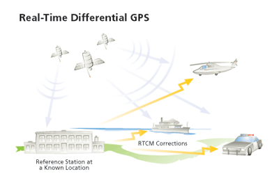
Real-Time DGPS
Real-time DGPS occurs when the base station calculates and broadcasts corrections for each satellite as it receives the data. The correction is received by the roving receiver via a radio signal if the source is land based or via a satellite signal if it is satellite based and applied to the position it is calculating. As a result, the position displayed and logged to the data file of the roving GPS receiver is a differentially corrected position.
The Radio Technical Commission for Maritime Services (RTCM), a nonprofit scientific and educational organization that serves all aspects of maritime radio communications, radio navigation, and related technologies, defined the differential data protocol for relaying GPS correction messages from a base station to a field user. Its Special Committee 104 (RTCM SC-104) format recommendations define the correction message format. Each correction message includes data about the station position and health, satellite constellation health, and the correction to be applied. Using real-time differential corrections allows navigation to within one to two meters of any location depending on the service and the GPS receiver.
Satellite Differential Services
Another method for obtaining real-time differential correction data in the field is by using geostationary satellites. This system obtains corrections from more than one reference station. Reference stations collect the base station GPS data and relay this data in RTCM SC-104 format to a Network Control Center, which sends the information to a geostationary satellite for verification. The verified information is sent to the roving GPS receiver to ensure it obtains GPS positions in real time.
The Wide Area Augmentation System, or WAAS, is being developed by the Federal Aviation Administration (FAA) to provide precision guidance to aircraft at airports and airstrips that currently lack these capabilities, using a system of satellites and ground stations that provide GPS signal corrections. Although not yet approved for aviation use, it is available to civilian users. WAAS is broadcast from geostationary satellites so the signal is often available in areas where other DGPS sources are not available. Two commercial satellite differential service providers, Thales Survey LandStar (formerly Racal LandStar) and OmniSTAR Inc., use a control hub where reference station data is checked, formatted, and uploaded to a geostationary satellite for rebroadcasting to subscribers.
DGPS radio beacon systems operate in many parts of the world. These stations—part of a large network that covers coastal areas, navigable rivers, and, more recently, inland agricultural areas—are used for marine navigation. However, these beacons have a range of a few hundred kilometers inland and can provide free real-time differential accuracy in the one-meter range, depending on the GPS receiver and the distance from the radio beacon.
Reprocessing Real-Time Data
Some GPS manufacturers provide software that can correct GPS data that was collected in real time. This is important for GIS data integrity. When collecting real-time data, the line of sight to the satellites can be blocked or a satellite can be so low on the horizon that it provides only a weak signal, which causes spikes in the data. Reprocessing real-time data removes these spikes and allows real-time data that has been used in the field for navigation or viewing purposes to be made more reliable before it is added to a GIS.
Postprocessing Correction
Differentially correcting GPS data by postprocessing uses a base GPS receiver that logs positions at a known location and a rover GPS receiver that collects positions in the field. The files from the base and rover are transferred to the office processing software, which computes corrected positions for the rover’s file. This resulting corrected file can be viewed in or exported to a GIS.
There are many permanent GPS base stations currently operating throughout the world that provide the data necessary for differentially correcting GPS. Depending on the technology preferred by the base station owner, this data can be downloaded from the Internet or via a bulletin board system (BBS). Because base station data is consistent (i.e., with no gaps due to multipath errors) and very reliable because base stations usually run 24 hours, seven days a week, it is ideal for many GIS and mapping applications. Sources of base station data for postprocessing fall into four categories—public sources, commercial sources, Web-based services, and base station ownership. Before purchasing a GPS receiver, it is best to identify the source of base station data.
Public sources—Government agencies worldwide collect and store base data. However, laws regarding public access to government data vary from country to country as well as between government agencies in the same country. Agencies that collect differential data have legitimate concerns, such as legal liability and cost recovery, that affect decisions regarding offering this data to the public.
Commercial sources—Some consulting firms and universities collect base data. Generally, this data can be purchased at per hour or daily rates. Information on these services can be found by browsing the Internet, by calling local base station distributors, or by talking to a local GPS sales representative. This can often be the most cost-effective way to obtain data for postprocessing.
Web-based services—This is an easy and economical way to process GPS data. GPS data is submitted to a service with some processing criteria specified. The GPS data is processed and returned. This approach is excellent for use with large field crews or when there isn’t time to train GPS users in processing techniques and requirements.
Base station ownership—This is the most flexible way to obtain base data for postprocessing but it has additional setup costs because two GPS receivers must be purchased and managed. If large amounts of data will be collected, the investment is often worthwhile.
Summary
To attain accuracy levels on the order of one to 10 meters, differential correction is essential. The three main methods currently used for ensuring data accuracy are real-time differential correction, reprocessing real-time data, and postprocessing. Each method will achieve similar levels of accuracy, so the decision regarding which technique is appropriate will depend on factors such as project specifications, the end use of the data, and the sources available for differential correction.
About the author