ArcGIS Video Server Allows Users to Perform Geospatial Video Analysis on the Web
In many industries—including utilities, defense, local government, and public safety—videos taken from multiple sources like drones, airplanes, and stationary cameras can help tackle issues that range from locating a rooftop leak to tracking a vehicle that’s transporting contraband.
ArcGIS users who have robust video collections have long sought easier ways to incorporate this data into their GIS workflows. A new server role in ArcGIS Enterprise called ArcGIS Video Server will enable users to create video services in ArcGIS and perform geospatial video analysis on the web.

What is geospatial video analysis and how can it support analytical workflows?
Performing analysis of geospatially enabled videos involves using a video and its relationship to the earth to understand what happened and when and where the event occurred.
The key to linking a video to a map lies in the video’s metadata. The video’s time stamp, the position of the vehicle in relation to the ground (the camera’s platform position), the camera’s orientation, and the location on a map where the camera is pointed (the target location) all provide geospatial context for the video. The more metadata that’s captured for a video, the better the geospatial context will be. This means that the video will more seamlessly integrate with a map and other available data sources.
In many cases, contextual details about someone or something’s actions or behaviors can be seen in videos, whereas they’re not as easily detected in single-frame images. For example, it might be difficult to determine if a photo of a truck with an open back and people around it depicts the truck being loaded or unloaded. Several photo frames or, better yet, a short video, could give analysts the context they need to determine that level of activity and categorize it.
Combining video with other data sources also allows analysts to monitor situations in near real time, collect observations, and compare past data to newer videos to make more informed decisions.
How do web-based services support video analysis workflows?
Imagine employees throughout an organization having the ability to easily share and collaborate on video analysis. What if instead of relying on email or cloud-based file hosting services to share large video files, employees could upload and publish videos so they stream over the web? This would enable anyone in an organization to use a portal to access the videos and analysis when they need them.
When users publish videos over the web, they are creating a video service. The addition of video services to ArcGIS Enterprise allows videos to be hosted on a server and consumed the same way that other Esri services are consumed.
To unlock this capability, Esri has created a server role for ArcGIS Enterprise called ArcGIS Video Server, coming out this fall. It allows users to publish their file-based videos so they stream over the web, facilitating quick and easy access. By web-enabling video, multiple users within an organization not only can work on the same archival or live footage but also can share their findings with stakeholders to foster quick decision-making about crucial operational tasks, such as tracking inventory, fixing damages, or deploying personnel on the ground.

How does Video Server work with other apps and software?
Through ArcGIS Enterprise, Video Server integrates with an organization’s ArcGIS system to support searching, publishing, streaming, and analyzing geospatial video through client apps that run on users’ devices. The primary client app that users can employ to interact with and publish videos is ArcGIS Excalibur, Esri’s web-based imagery analysis app. With the release of Video Server, the capabilities in Excalibur will be expanded to enable users to search, access, use, and share videos in addition to imagery.
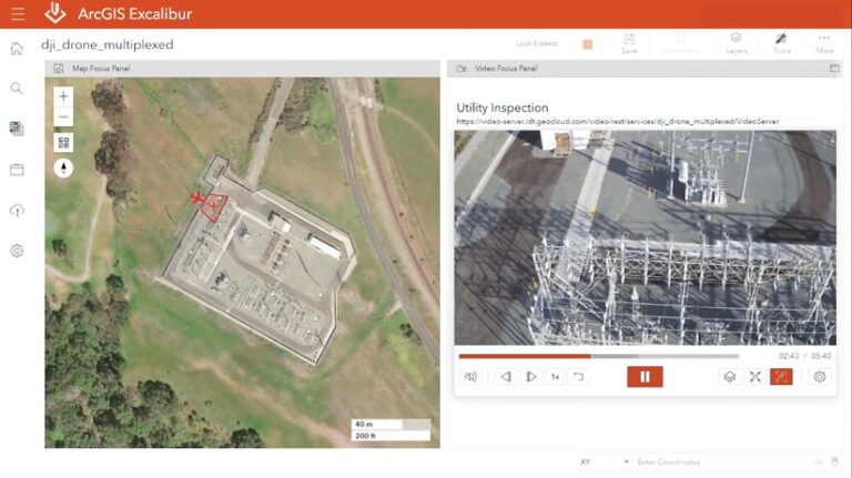
Through the Excalibur interface, users can upload videos to Video Server to view them as a service and play them alongside their telemetry on a map. Users can also plot observations on the map and capture video frames to measure or count objects seen in a video. Excalibur provides ready-to-use tools and workflows that make interacting with videos simple and intuitive.
For users who employ the ArcGIS Imagery Analyst extension in ArcGIS Pro and/or use ArcGIS AllSource, they will be able to consume video services from Video Server with the ArcGIS Pro 3.3 release coming this spring. Support for consuming video services in web apps and dashboards will be added soon as well.
How can using video services in Excalibur streamline operational tasks?
Certain operational tasks—like monitoring a large-scale facility such as a utility network or an airport—need the kind of high-level view that only drones and other aerial cameras can provide. With Excalibur, observations that have traditionally been made on the ground can be done remotely, via video, with significantly less cost and, in some cases, reduced risk to human life. This makes large-scale operations more efficient.
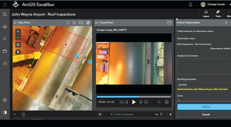
For example, OC Survey, which is part of Orange County, California’s public works department, used a dedicated fleet of drones to capture footage of the roof of John Wayne Airport and detect the source of a water leak.
Once the footage was captured, staff from OC Survey—an early adopter of Video Server—uploaded the video to Video Server and, using Excalibur, played it alongside its map telemetry until they found the leak. Employing Excalibur’s Capture Video Frame tool, staff members took a screenshot of the video frame that showed the leak and placed it on the map panel. Then, using Excalibur’s built-in observation tools, the team placed an observation point on the screenshot, wrote details about the leak in the comments section, and sent the web map and the screenshot to John Wayne’s service team.
The leak was repaired faster and more efficiently than if its discovery had been made in person.
How to get started
In gearing up for the fall release of Video Server, start exploring Excalibur. Get familiar with its tools and built-in workflows for imagery, and get ready to use them with video. ArcGIS Enterprise users with a Creator or GIS Professional user type extension can add Excalibur to their deployments as a premium app.
Get more information about Excalibur, and sign up to be notified when Video Server is available.

