The United States Environmental Protection Agency (EPA), which plays a critical role in protecting and improving water quality and making decisions regarding how water resources are used, is replacing paper-based maps and aerial photography prints with GIS and imagery.
The demands of climate change and population growth are affecting the lakes, rivers, streams, and underground aquifers that supply fresh water. Across the United States, communities of all sizes are facing the need for increased, sustainable access to freshwater resources. A 2014 report by the US Government Accountability Office, Freshwater: Supply Concerns Continue, and Uncertainties Complicate Planning, noted that water managers in 40 of 50 states expect shortages of fresh water to continue to increase in the next decade.
Although analog methods served EPA well in the past, they are no longer efficient and are being replaced with digital ones. EPA employs a variety of geospatial tools to complement its standard photogrammetry practices. Photogrammetry is the science of obtaining reliable measurements from photographs and digital imagery to produce products such as orthomosaic maps, GIS data layers, or 3D models of real-world objects.
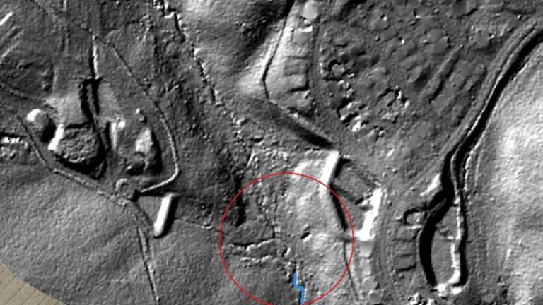
EPA has established a unique, iterative process to develop information that supports enforcement of its cases. Once EPA embraced the power of remote sensing and digital mapping, it realized these tools can help with its investigations. GIS helps EPA answer questions about how wetlands have changed over time and understand the impacts of its decisions on commerce.
Bringing Orthomapping and Digital Maps Together
EPA recently began exploring the use of orthomapping in ArcGIS Pro. More advanced image analysis capabilities, provided by the Esri orthomapping suite, are available in the ArcGIS Image Analyst extension.
With orthomapping, historical information augments current data to make better decisions that support EPA’s work enforcing the Clean Water Act (CWA) and the Comprehensive Environmental Response, Compensation, and Liability Act (CERCLA). CERCLA provides federal funding to clean up uncontrolled or abandoned hazardous-waste sites.
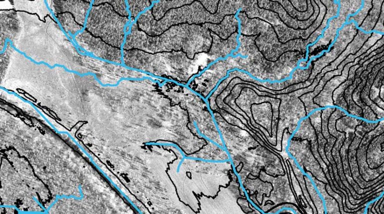
Orthomapping capabilities in ArcGIS Pro provide critical support for EPA studies by accurately placing raw historical photos into the same view with existing datasets and maps. Before transitioning to ArcGIS Pro, paper maps and photographic transparencies were viewed on a light table with traditional optical devices. It was a slow and tedious process that involved manually positioning film or prints that could easily get out of alignment.
Changes over Time
Peter Stokely has worked as an environmental scientist at EPA for more than 30 years. His work for the EPA water enforcement division in Washington, DC, has focused on using imagery analysis and GIS to provide accurate analyses of water resource sites.
“My focus has been [on] helping compile the facts to support enforcement cases for Section 404 of the Clean Water Act, which is the part that protects our nation’s wetlands and streams and rivers from being filled with solid material. We are working to protect the environment,” said Stokely.
Stokely uses GIS and photogrammetry to support advanced spatial analytics. He looks at current and historical imagery to digitize changes over time. His work helps answer critical questions about the location of wetlands under federal jurisdiction and whether those lands are being managed in compliance with the law. His work combines imagery and mapping with field data.
Historical imagery is useful for more than understanding landscapes. It helps in evaluating the historical impacts to a local water resource. This imagery is necessary when studying a property that is subject to pollution to determine the source and timing of contamination and provides the EPA with context for Clean Water Act enforcement. Asking critical questions about an area’s past can help guide decisions and identify possible future implications.
“You can make a lot of interpretive mistakes by just viewing two-dimensional imagery,” Stokely said. “ArcGIS provides the ability to incorporate other geospatial data layers, such as contour lines and digital elevation models, to inform imagery interpretation. With orthomapping, the ability to view and pan around three-dimensional images on a computer screen is amazing. You know how crisp the imagery can be and then how the three-dimensional image can be so realistic.”
Making Decisions in 3D Context
In addition to producing more accurate images that are faster to review, aerial photography in a 3D format helps decision-makers see original imagery in a mapping context and identify relevant facts about authenticity.
Updated digital maps enhance but do not replace historical data. They create a new level of rigor and analysis. Compiling detailed information about a specific site for one or many time periods can be critical to understanding and documenting the site’s current state and guide decisions about its future.
In the future, there will likely be continued enforcement actions under CWA. In addition, there is an increasing need to understand the impacts of climate change and human activities on natural landscapes. ArcGIS Pro provides EPA with GIS capabilities in a powerful, single desktop application that supports data visualization, analysis, and authoritative data maintenance.
Stokely believes that there are more applications for GIS in the future. “There are still things to discover in historical imagery about past pollution events where three-dimensional viewing is helpful,” Stokely said.