The City and Urban Design team at Gensler has recently explored the capabilities of GIS to create plans, visualize scenarios, and support collaboration and decision-making. A renowned international design firm, Gensler is the largest architecture, design, and planning firm in the world. The company designs large-scale, mixed-use urban communities as inviting places for people to live, work, and play.
While GIS is commonly used in the urban planning and design process, it is normally used for site selection and analysis. Planners and designers use GIS to understand the topography, hydrology, demographics, and government regulations of an area, which informs the design of the project.
During the complex processes of urban planning and design, data collection, analysis, and visualization efforts are used to support decision-making, according to Le An, a senior urban planner and urban designer at Gensler’s Washington, DC, office. He notes that the rapid development of 3D and interactive GIS technology benefit urban planners, who can now adopt a
more integrative and dynamic approach to managing and moderating planning and design tasks. This better serves the communities in which these projects are being built.
“We use both speculative site study and real-world urban design projects to develop and test our development framework. This enables us to integrate real-world GIS data, quickly create plans and models for multiple scenarios, evaluate the metrics, and perform spatial analytics of potential impacts,” said An. The team uses visualizations created in Esri CityEngine, web scenes, and ArcGIS StoryMaps to communicate ideas and designs to clients and stakeholders more effectively through the interactive 3D web applications.
The standard approach for most design firms is to show visualizations to clients as Microsoft PowerPoint presentations or as printed drawings. Sometimes 3D rendering companies are hired to create 3D models of proposed concepts. Unfortunately, all these methods provide only static representations.
The City and Urban Design team has found that showing clients visualizations as 3D web applications makes presentations more engaging and interactive. In addition, when feedback from clients includes new information or requests, these can be incorporated much faster, and design iterations and visualizations are easier to create.
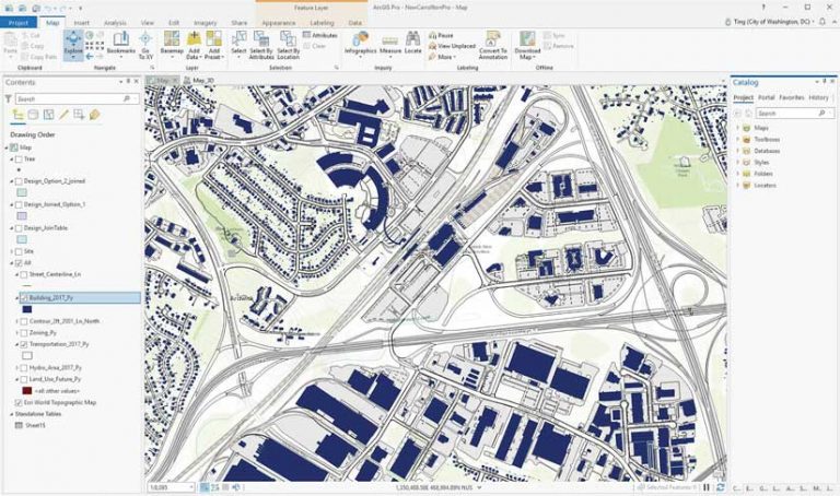
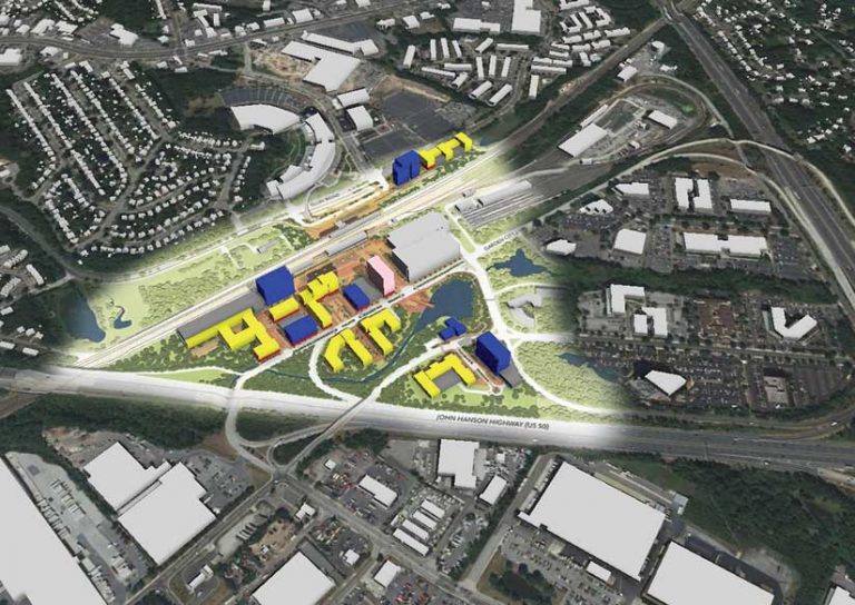
“The design and construction of a master planned community requires several stages. We use GIS throughout the entire process,” said An. In the initial stage, the team uses ArcGIS Pro to perform the various analyses needed to understand the site and its surrounding environment. Using ArcGIS Pro and Esri CityEngine, the team quickly converts 2D designs into detailed, large-scale 3D city models.
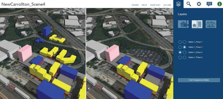
These 3D city models are smart models because they contain all the attribute data created in ArcGIS Pro. In CityEngine Web Viewer panes, special tools allow interaction with data layers in a 3D web scene.
“This allows us to present different design scenarios and project phases to our clients by turning different layers on and off in conjunction with the slider, swiping, and using side-by-side comparison tools,” said An. “It also has a feature called bookmarks. By moving between different preselected images, the [Web] Viewer can create a little animation, which provides a more engaging and immersive experience for our clients.”
CityEngine also has shadow and visibility analysis tools that can envision the real impact of building designs on surrounding areas. Using ArcGIS Online, a user can share 3D web scenes so that projects can be viewed by clients and other stakeholders. Recent releases support KML editing, mobile, and using large data files disconnected from the internet. An values this because it supports better communication and more informed decision-making.
Clients and stakeholders can see detailed information about a proposed design because every element in the 3D web application is clickable, so they can access metadata from ArcGIS. This metadata can include information such as a building address, current use, height, square footage, and ownership.
After approval, GIS-based 3D models, as well as related plans, are handed off by the urban designers to the architect so that the design can be further developed in the building information modeling (BIM) environment. A construction company uses the BIM model to build the project. BIM can include extensive smart facilities data that can be used for architectural design and engineering; mechanical, electrical, and plumbing (MEP) applications; structural engineering; and building construction.
Because many municipalities and local governments maintain open GIS data portals, Gensler can obtain high-quality data about parcels, lots, land use, water bodies, and roads, transit lines, and bus stops. Environmental data includes contours, topography, hydrology, and fault lines.
Building footprints that include height attributes are also available from the portal. Using the CityEngine procedural modeling tool, thousands of 3D buildings can be quickly generated from the building footprints for design concepts.
“I think design has the power to connect together the existing built and natural environments with technology to create a more livable space in our future communities,” concluded An. He feels that GIS has allowed the team to better understand, evaluate, and analyze what is behind the physical appearance of communities, providing a deeper understanding of how a community works through analyzing data about it.
In the future, An would like to collaborate with the firm’s architects. He would like to take the detailed model in Revit or BIM and load it into his 3D model in ArcGIS Pro so that architects can better understand how their designs impact the community. The team could help them with additional analysis. He believes that ArcGIS Urban will be a great addition to this rapidly evolving technology and “will continue to push the envelope of smart urban planning and design.”
About the author