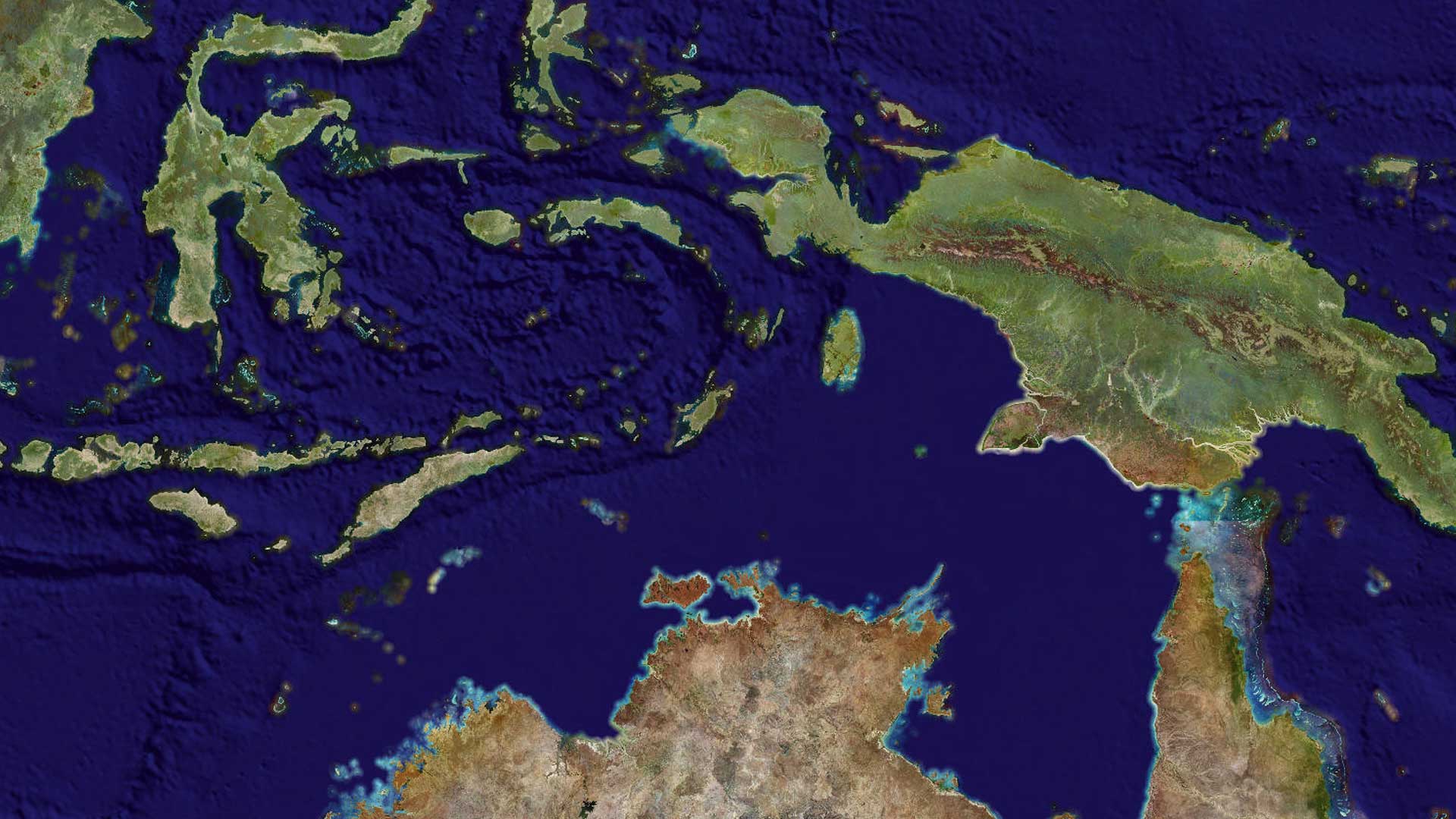
In June 2021, Esri released a new high-resolution 2020 global land cover map and made it available to everyone on the ArcGIS Living Atlas of the World. The Esri 2020 Land Cover map is the first map to possess this level of comprehensiveness, currency, and detail, and it is a vital resource for better understanding and preserving the world.
With its 10-meter resolution, this map can be used to help determine the characteristics of a particular place and answer questions such as these:
- Is an area bare ground or is it covered by trees or water?
- Does it contain buildings or other infrastructure?
- How has it changed over time?
To support answering these and other questions, high-resolution, open, accurate, comparable, and current land cover maps are critical for decision-makers in many industry sectors and nations with low- and middle-income economies. This will enable the surface of the earth to be characterized and classified into a manageable number of categories to identify and better manage resources.
Mapping the Earth’s surface will assist with land-use planning, hydrologic modeling, and resource management planning. National government resource agencies can use land cover as a basis for understanding trends in natural capital and help define land planning priorities such as food production or conservation.

A New Methodology
Typically, the value of land cover maps is diminished because the time between data acquisition and map availability can span several years. However, the use of artificial intelligence (AI) allowed this global land cover map to be produced in less than a week.
The Esri 2020 Global Land Cover map was built using European Space Agency (ESA) Sentinel-2 satellite imagery. It was created using a deep learning AI land classification model developed by Impact Observatory, on a massive training dataset of more than five billion labeled image pixels developed by the National Geographic Society. The global map was produced by applying this model to the Sentinel-2 2020 scene collection, processing more than 400,000 Earth observations of Land Use/Land Cover (LULC)—approximately 500 terabytes of imagery—hosted in the Microsoft Planetary Computer.
The dataset included more than 24,000 five kilometer by five kilometer areas from all the world’s major biomes. The model was run on six bands of Sentinel-2 surface reflectance data: one band each of visible blue, green, red, near-infrared, and two shortwave infrared bands. The 10 classes generated are water, trees, grass, flooded vegetation, crops, scrub/shrub, built area, bare ground, snow/ice, and clouds (unclassified).
To create the final map, the model was run on multiple dates of imagery throughout the year, and the outputs were composited into a final representative map of 2020. The complete global run was approximately 1.2 million core hours of compute time. To complete the task in approximately a week, Microsoft Azure Batch was used to run up to 6,400 cores simultaneously.
The new map will be updated annually, supporting change detection and highlighting planetary land changes, especially related to the effects of human activity. Later in 2021, Esri and Impact Observatory will make this new land cover model available to support on-demand land cover classification, allowing the GIS community to create new land cover maps for project areas as often as every week. This model will empower land managers and disaster response organizations that need to monitor change in a specific area of interest, provide near real-time environmental situational awareness, or look at long-term change and seasonal differences in land cover.
Benefits and Uses
Publishing the Esri 2020 Land Cover map as a tile imagery layer on ArcGIS Living Atlas of the World makes it available for visualization and analysis in ArcGIS Online, ArcGIS Pro, and other client applications. GeoTIFF tiles of the layer can also be downloaded individually for areas of interest, or the entire 60 GB collection can be downloaded with a single click. Esri released this valuable resource under a Creative Commons license so that it can be downloaded by anyone.
“This is a critical year for climate action,” said Jack Dangermond, Esri founder and president. “With the UN Climate Change Conference of the Parties [COP26] bringing international parties together to address a set of common goals, we are happy to do our part in making this map available to users who are working toward the health of our planet.”
This data is globally consistent, which allows for comparisons across country boundaries, and it is complementary to existing national data, filling data gaps in remote and less-developed areas where detailed recent data may not be available. Using this 2020 land cover data can help countries identify national priorities and support national and subnational level reporting.

Users can visualize and analyze the land cover data in association with population, hazard, terrain, hydrology, weather, and other GIS layers, available in ArcGIS Living Atlas of the World or from their own organization. A consistent map of land cover for the entire world can be combined with other data layers for green infrastructure, sustainability projects, and other conservation efforts that require a holistic picture of both the human and natural footprint on the planet. Examples of these types of projects could include the following:
- Computing the percentage of land in a watershed categorized as built area, which will contribute to faster rainfall runoff and increased flood risk.
- Identifying coastal areas of built area and crops less than three meters in elevation that may be susceptible to storm surge.
- Intersecting land cover and species richness layers to determine conservation priority areas
Planners worldwide will be able to better understand site geography and make more informed decisions. Getting this data into people’s hands is a key component of this mapping initiative. More than 10 million GIS users have direct access to it via web services in ArcGIS Living Atlas of the World.
Although the global land cover map has only been available since June 2021, organizations are already benefiting from it. Rafael Monge Vargas, director of Centro Nacional de Información Geoambiental, noted that, “Understanding the most up-to-date land-use and land cover information of Costa Rica at 10-meter resolution is a groundbreaking input for our national planning processes, including for the development of ‘maps of hope’ that identify Costa Rica’s essential life support areas—where the implementation of nature-based solutions can lead to greater environmental, economic, and social benefits.”
Access the Esri 2020 Land Cover layer or learn more about it.