Two Florida government organizations used GIS to coordinate efforts to protect native animals from predation by the Burmese python (Python molurus bivittatus). This large constrictor, which is native to Southeast Asia, was introduced to Florida through the exotic pet trade industry. Burmese pythons have survived in the wild because south Florida has a subtropical climate and expansive regions of suitable habitat.
With a large reproducing population and almost no natural predators, Burmese pythons have become one of the most destructive invasive species within Everglades National Park and the surrounding natural areas. According to a 2011 journal article in the Proceedings of the National Academy of Sciences (PNAS), road survey observations of mammals throughout southern Florida show a dramatic decline in raccoon, opossum, and bobcat populations, and these findings suggest the decline is due to predation by Burmese pythons.
The limited options available to control this predator led the South Florida Water Management District (SFWMD) and the Florida Fish and Wildlife Conservation Commission (FWC) to collaborate in 2017 to develop independent but parallel incentivized python removal programs. In 2019, Florida governor Ron DeSantis directed these two programs to align in land access processes, program regulation, and python removal requirements.
Together, the programs maintain a roster of 100 removal agents under contract. These agents are trained to safely and humanely remove pythons and other invasive snake species from Florida’s natural areas, which cover approximately 4 million acres, span 11 counties, and include more than 1,000 miles of gravel levee roads. Enhanced interagency coordination and collaboration have optimized invasive constrictor detection and response, and the total number of pythons removed since 2017 is nearing 12,000.

Survey Data and Agent Accountability
Both programs deploy experienced python removal experts to specific areas and compensate them for conducting surveys, collecting useful data while searching for snakes, and removing pythons from public lands. Initially, removal agents manually recorded date on search efforts and snake captures on paper forms. This system was not only inefficient and labor-intensive, but also produced low-quality data.
In 2018, SFWMD senior invasive-animal biologist and python elimination program manager Mike Kirkland approached the geospatial technology team at SFWMD for potential alternatives to paper forms. Geospatial technology developer Amy Peters provided an innovative solution through customized Esri mobile applications that standardized data collection, produced substantial operational efficiencies, increased program data collection, automated invoicing, and improved data quality. These enhancements informed program optimization and guided management decisions, benefiting not only SFWMD but also Burmese python control efforts by partnering agencies.
Employing Esri mobile applications for python removal programs is an adaptive data collection strategy that is continually improved. Each update to the mobile app solution has streamlined the workflow and made the dataset more consistent. In 2021, an organizational group sharing capability in ArcGIS Online let SFWMD offer the same solution to the FWC python removal program and unify the two agencies’ datasets.
ArcGIS Survey123 has been instrumental in field data collection by python removal agents. “Survey123 is a one-stop shop for entering all required information for each survey including our itinerary, our method of travel, passengers, and more,” according to removal agent Anthony Flanagan. “Submitting the survey autogenerates email notifications to FWC wildlife law enforcement officers and serves as a written record so that we no longer need to call in when entering and leaving program lands.”
Python Removal Payments
Peters configured two surveys from a common feature service: one survey for removal agents to enter field data, and one for agency staff to enter morphometric data for pythons being checked in to calculate incentive payments. The two surveys are connected by an inbox that is utilized when python captures are recorded in a removal agent’s field survey. Each capture is assigned a unique snake ID. Pending check-in of these captures, agency program managers can access capture records to add attributes such as body length, weight, sex, and euthanasia method attributes for each python.
Removal agents are paid $50 for pythons up to four feet long and $25 for each additional foot. The app’s autocalculation capability efficiently determines the total payment for each snake, down to the half inch. If a submitted field survey does not contain a python capture or the check-in survey is completed and submitted, the survey is designated as complete and will not be returned in the inbox query.
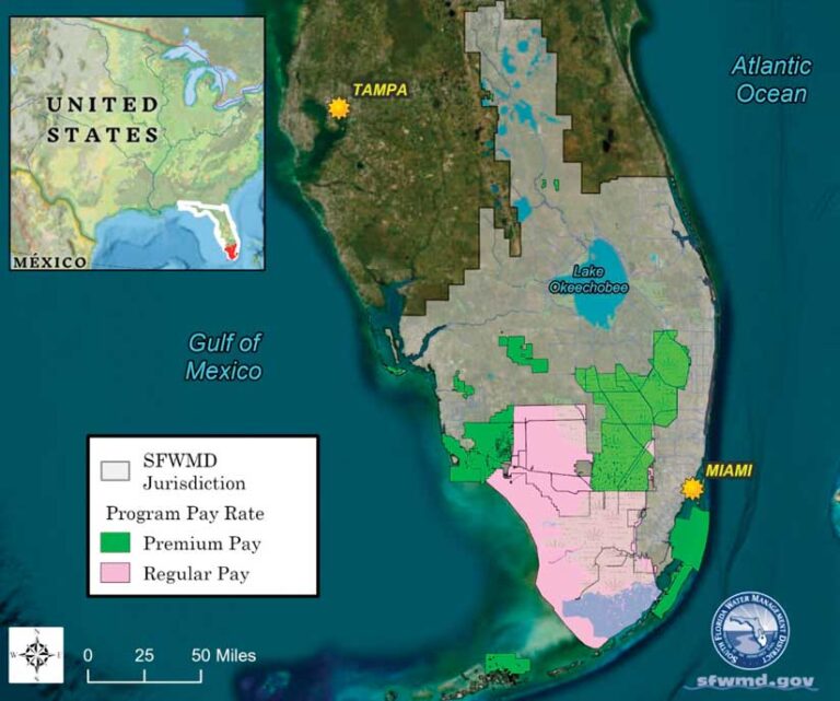
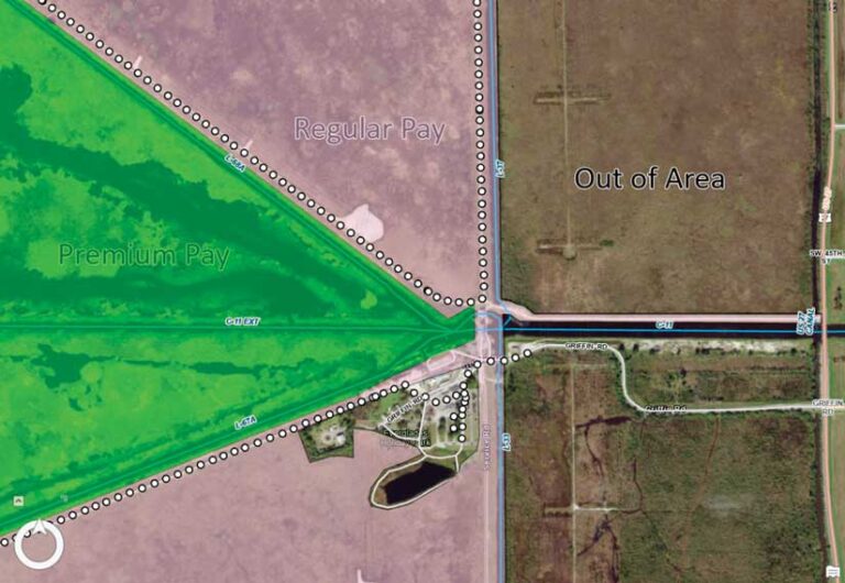
In addition to snake captures, python removal agents are paid for the time they spend surveying within designated program land boundaries. These areas include federal, state, and county-managed lands both within the core python population area and on the periphery of the known Burmese python range in Florida. Program areas continue to expand as new lands are included and new regions are identified as being at risk of Burmese python invasion.
Priority areas are those areas where pythons may be hard to locate, such as at the leading edge of a python range with lower population densities, or where there are sensitive native animal populations that are vulnerable to predation. In these areas, removal agents are paid a higher hourly rate to incentivize surveys.
To address the spatial component of pay rates, agents select a hyperlink from their survey to open ArcGIS Field Maps to view their location with an overlay showing areas that pay the regular hourly rate and areas that pay a premium rate. If removal agents turn on My Tracks when they operate within the project area, their track point data is spatially intersected with a highly detailed delineated program lands polygon layer. That layer is maintained in ArcGIS Pro by Heather Kostura, SFWMD geospatial data supervisor.
Automating Payments
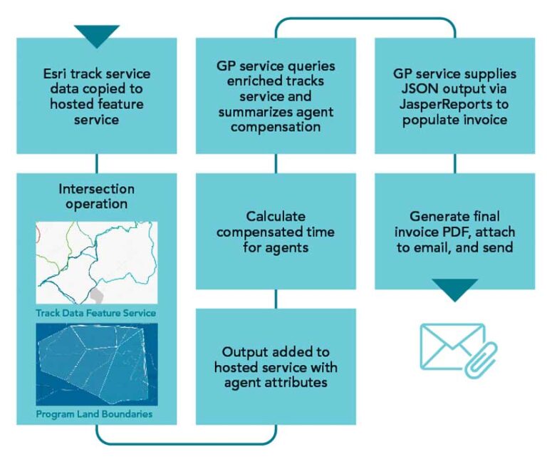
Invoicing removal agents directly as an attachment to their email became a reality when geospatial lead developer Jamie Crandall pieced together two complex steps. First, a local Python script on a Windows Server virtual machine executes each hour via the task scheduler. The script copies track data from the Esri tracker service into a new hosted feature service. This ensures data is preserved, since Esri sunsets data from the default tracker service after 30 days.
The same script performs a spatial intersect of track points and program lands. The results are added to a hosted service containing agent attributes, such as vendor identification numbers. The enriched tracks service that is generated contains all the attributes needed to fill in invoices: the land management area identifier, pay rate, contractor information, and millions of point locations with date and time stamps.
The time when a given agent entered and exited a given management area is known so staff can simply calculate the elapsed time spent surveying there and create invoices, right? Not quite.
Pythons are primarily nocturnal hunters, which does not align with a conventional workday. Python removal agents can be on the job 24 hours a day, 365 days a year, but will be compensated for a maximum of 10 billable hours per calendar day. In addition, they can enter and exit program lands at their convenience, traverse several program lands in the same survey, or even camp within an area for any length of time.
Removal agents are only compensated for actively searching program lands. They aren’t paid for time spent eating, camping, or other similar activities. Program logic needed to include criteria for setting the elapsed time back to 0 if the motion sensor on the agent’s phone has been stationary for more than 30 minutes. Moreover, elapsed time must be set back to 0 if the contractor leaves the program area or travels into a different land polygon.
Once the elapsed time column was adjusted to account for the level of detail needed to model the behavior of a removal agent, the second step was accomplished by applying this cumulative logic to the geoprocessing (GP) service. A query of the enriched tracks service within a pay period for each agent is sorted by date and time and correctly summarized with a group-by statement on date, pay rate, and sum of elapsed time.
Lastly, the GP service supplies output in JSON via JasperReports software to populate a prebuilt template designed by IT lead developer David Stevens and generates a final invoice PDF that is attached in an email and sent to removal agents and program managers.
Safety, Data Analysis, and Data Maintenance
Prior to being used for automated invoicing, track data was a crucial support tool for program managers who monitor the real-time incoming locations of removal agents in the field using Esri’s Track Viewer. This app helps optimize agent coverage of the project area, verify agent activities, and analyze search effort efficacy, as well as adding an invaluable layer of safety to the program.
The Everglades—especially at night—can be a very dynamic region. Being able to determine an agent’s exact location within remote lands can be vital when directing assistance. On one occasion, Kirkland used Track Viewer to find the current location of a removal agent who was struggling to capture a 17-foot python in the water. Kirkland was able to locate another nearby agent, who was sent to help successfully remove the python and prevent injury to the agent.
The survey data is accessed via ArcGIS Online by an interagency group led by Ed Metzger, an invasive-animal biologist and herpetologist, who is a project manager at the University of Florida. The data is reviewed for accuracy and any errors corrected. Then geospatial tech developer Brian Diunizio links the survey feature layer with associated track data based on removal agent name and corresponding survey time stamps to create a spatially delineated survey dataset in spreadsheet form.
A time component is factored into the monthly summary table. For each removal agent survey, an elapsed time stamp corresponds to each land crossing. Adding this layer of spatiotemporal accuracy is valuable to program managers, who filter and deliver the data to partner agencies to document monthly survey efforts and captures by land area.
This data can be downloaded by contract invasive-species biologist researchers at the University of Florida to analyze spatiotemporal trends and covariates for a more comprehensive assessment of python behavior. To increase removal rates, the long-term goal for data analysis includes advanced biometrics for predicting python behavior patterns.
In addition to biological reports and publications, ArcGIS StoryMaps and ArcGIS Dashboards apps have been essential in quickly and effectively communicating with decision-makers. The python removal program lends itself to different dashboard products for removal agents, program and agency managers, and statewide lawmakers (which is in development).
The removal agent dashboard displays the data of individual contractors and shows the total number of captures, total hours worked, and capture locations. This dashboard uses a restricted-view layer that prevents other contractors from viewing the information. A separate web map with a time delay on the capture layer displays captures by month so that agents can plan future survey locations based on seasonal hot spots. The agency management dashboard provides insight into which program lands are being surveyed most frequently and includes removal agent performance metrics. It also displays a quarterly breakdown of captures for reporting purposes.
The feature layer contains millions of enriched track points, and the survey feature layer has many large photo attachments. These layers require a data maintenance workflow to back up these hosted services and sunset the data to reduce storage credit usage in ArcGIS Online. Track points are inserted into a local file geodatabase for archiving, and the ArcGIS Survey123 data sources are downloaded as zipped file geodatabases. All these tasks are completed with a collection of local Python scripts and hosted notebooks on ArcGIS Online that are scheduled to run at defined intervals.
“Data standardization and quality control are critical needs for the python removal program. Our geospatial team successfully leveraged Esri applications and tools to meet our data management goals while dramatically increasing efficiency,” said LeRoy Rodgers, the section lead for SFWMD Vegetation and Invasive Species Management.