Three Valley Conservation Trust (TVCT), a nonprofit land conservation organization in Oxford, Ohio, needed to identify and prioritize land parcels for conservation easements that would help protect streams and riparian zones, promote prime production of agricultural land, and decrease the potential for habitat fragmentation.
Nonprofit land trust organizations, such as TVCT, implement environmental planning by working toward permanently preserving habitat, open space, and dynamic landscapes on private land, using different conservation strategies such as conservation easements. This strategy permanently limits land uses through a custom legal agreement to protect the natural and/or agricultural values of the land. According to the Land Trust Alliance, in 2018 there were 1,363 land trusts in the United States.
Easement acquisition is restricted by limited funding sources. Land managers are tasked with maximizing efficiency in the conservation planning process by prioritizing areas with high ecological value. Local land conservation organizations like TVCT can benefit from prioritization tools that enable data-driven decision-making.
Three Valley Conservation Trust
Founded in 1993, TVCT primarily targets riparian habitat and agricultural land in southwest Ohio. It protects land through conservation easements that span seven counties in southern Ohio and Indiana. TVCT’s goal is to implement widespread protection of open space, watersheds, and communities for present and future generations.
The land trust works toward this goal through sale or donation of conservation easements. leveraging federal and state grant funding, TVCT places permanent easements on private property.
Its funding comes from organizations and agencies such as The Nature Conservancy (TNC), the Ohio Environmental Protection Agency (OEPA), and the Local Agricultural Easement Purchase Program (LAEPP).
To more effectively spend its available funds, TVCT wanted a parcel prioritization tool developed that would assist in targeting easement placements. A research assistantship was granted to Meghan Jones, a graduate student at Miami University, who would undertake development of this tool for her master’s thesis. She created the prioritization tool using Esri’s ModelBuilder, saving TVCT both time and money.
Creating the Priority Model
The tool, the Land Priority Protection Model (LPPM), utilizes ModelBuilder in ArcMap 10.6 to identify areas of land best suited for conservation. It applies conservation criteria to private land to weight, rank, and strategically score parcels. The decision support criteria are the fundamental components of LPPM.
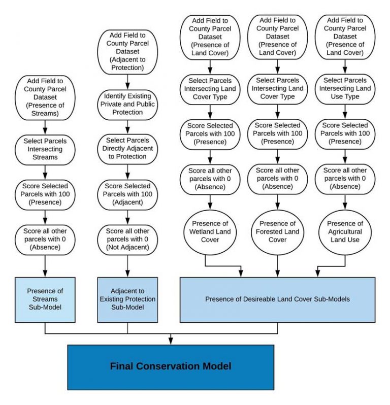
TVCT identified three overarching evaluation criteria for identifying potential parcels of high value: presence of streams, adjacency to existing protection, and the presence of desirable land-cover/land use (land cover/land use types include wetland, forest, and agriculture use). Each criterion is evaluated within its own submodel and calculated individually. The final conservation model is computed last to accommodate all other criteria calculations. While the primary purpose of the model is to identify high-priority land to apply conservation easements, the model needed to be versatile so that variables can be excluded or weighted differently.
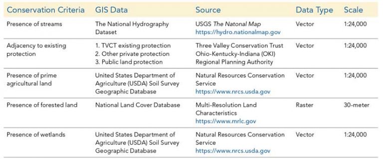
Three Valley Conservation Trust is a nonprofit agency with limited funding. It favors using publicly available data sources such as the National Land Cover Database and the National Hydrography Dataset for analysis. Some of the open data sources are listed in Table 1. All data utilized wascollected through free national or state platforms; this is very important to the land trust for several reasons such as cost, availability and reliability. After collection, all data were imported into ArcGIS and reprojected to NAD83 Ohio South State Plane Feet, clipped to the study area, and imported into a geodatabase before being included in the model.
ModelBuilder as a Useful Solution
ModelBuilder was chosen as the main platform for data manipulation and analysis for its versatility. Several toolbox tools with different workflows were created, which cut down the time that would normally be spent opening and running separate tools. ModelBuilder is a visual workflow creator that offers a flexible interface, providing easy editing and streamlining automation of frequently run processes. Users can assess conservation criteria individually and together.
LPPM automates the process of prioritizing parcels based on various conservation scenarios. When using the submodel, the user determines whether to include or exclude criteria and assigns relative weights to each criterion. For example, if a funding agency prefers different conditions or criterion weight for conservation easement applications—such as the presence of wetlands—those variables can be weighted higher before running the final priority model.
Submodels for Individual Conservation Criterion
Each criterion for identifying potential parcels of high value is handled by a sub-model. Each submodel has a specific purpose: to create an attribute field for holding score. For example, the Presence of Streams submodel selects every parcel in the study area that intersects a stream and assigns it a score of 100 because a stream is present. All parcels that don’t intersect a stream receive a score of 0, denoting the absence of streams.
After each submodel has been run, the parcel dataset contains five new fields that hold scores for each evaluation criterion. The appended parcel dataset is then used to run the final conservation model.
Final Model and Results
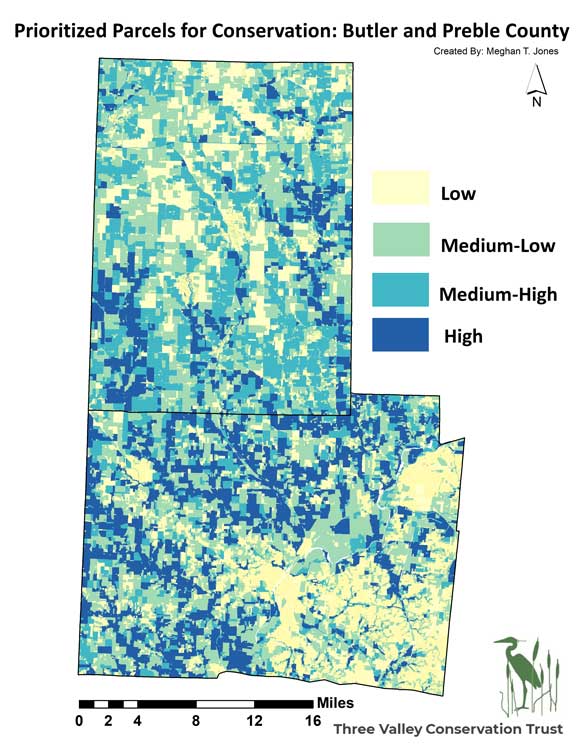
The final analysis adds a field to the parcels dataset to store the final priority score. This score is calculated as a sum of each criterion present for each parcel multiplied by the individual weight assigned, which ranges from 0–100. A weight of 100 represents the most desirable land for conservation, and a weight of 0 represents the least desirable land for conservation. Results are symbolized in even quantiles from 0–100 based on the final conservation index parcel score. Of 201,477 parcels evaluated, only 514 (0.2 percent) scored a perfect 100, while 3,777 parcels (1.87 percent) contained the highest priority score ranging from 75–100.
Passive to Active Planning Approaches
Prior to the completion of LPPM, TVCT primarily followed a passive approach to land conservation, relying on landowners to initiate the decision to protect property from development and begin habitat restoration. While this resulted in more than 23,000 acres being placed in conservation easements, this approach does not always protect higher-risk ecosystems and can result in habitat gaps.
By utilizing LPPM, TVCT can analyze open-source data and identify at-risk ecosystems. Mapping natural resources using weighted criteria helps illustrate how private parcels of land impact biodiversity and ecosystem services on a landscape level. For example, this model could provide the land trust with a way to examine which parcels should be set aside to provide contiguous habitat along a riparian corridor, rather than focusing on land use/land cover.
Conservation funding is limited and so is the amount of land it can ultimately protect, so it is important that TVCT scrutinize available funding projects and protect parcels that will provide the greatest ecological benefit. LPPM allows TVCT to be proactive and educate landowners who may be less inclined to support local land protection on the ecological value of their property. Engagement and education aim to increase involvement with the community to promote habitat preservation or protection.
Leveraging model results, the land trust shifted from predominantly passive methods to proactively seeking out appropriate land for conservation and then finding a funding source to aid in the easement acquisition. The maps created using LLPM will help communicate land protection issues as they relate to landowners’ holdings, and target donors for restoration projects.
Following the initial analysis and selection of strategic habitat using the LPPM, TVCT exported the selected parcels to unmanned aerial systems (UAS) mapping software loaded on Apple iPads. The staff used UAS technology and software to obtain current aerial images and vegetation indexes. In addition, field staff used the maps to guide biological surveys, draft habitat restoration/protection plans, and create detailed presentations for meetings and workshops.
The Future Use of LPPM
Going forward, TVCT plans to continue employing the LPPM as a means to identify habitat zones hosting vital or at-risk native flora and fauna. As funding sources are identified, the conservation trust will adjust data layers and feature class weights to align strategic mapping with funding partner criteria. This flexibility allows TVCT to maximize its impact by leveraging collaborative funding from multiple sources. LPPM helps visually communicate conservation initiative goals, illustrate the initial planning and assessment steps, and significantly increase community outreach and financial support.
LPPM is free to access, and a step-by-step user guide helps GIS technicians at partner conservation groups re-create the methods used in this analysis and incorporate industry data layers. [See the online version of this article at esri.com/arcuser for links to the model, guide, and resources consulted.]
For more information, contact Meghan T. Jones.
Acknowledgments
This work was completed under the guidance of Robbyn Abbitt, GISP, the GIS coordinator and master’s research adviser in geography at Miami University in Ohio.
About the author