Using Africa Geoportal, Esri’s open GIS community data and mapping platform, volunteers from the Geohazard Risk Mapping Initiative (GRMI) created a real-time flood reporting tool, interactive flood maps, web applications, and a comprehensive flood event database. GRMI’s work helps communities in Nigeria prepare for and respond to recurring flooding events spurred by changes in rainfall patterns attributed to climate change.
A youth-led nonprofit organization, GRMI volunteers are skilled at using GIS tools and analyzing satellite imagery. They use these skills to create maps and applications of current or anticipated geohazards caused by the impact of climate change in Nigeria and other African countries. Their susceptibility and prediction maps and applications are created at local scales and shared with disaster and emergency management organizations, government ministries, and others. Since its inception in September 2020, GRMI has assembled a team of 20 youth GIS volunteers skilled in hazard mapping.
The work of GRMI supports the United Nations’ Sustainable Development Goals (SDGs) 11 (Sustainable Cities and Communities) and 13 (Climate Action). GRMI activities also align with the goal of the Sendai Framework for Disaster Risk Reduction agreement to substantially increase access to multihazard early warning systems and disaster risk information assessments.
On the Front Line of Climate Change
According to the Centre for Research on the Epidemiology of Disasters (CRED), floods accounted for 43.5 percent of all deaths from disasters in 2019, marking an increase in events compared to previous years. Furthermore, floods disrupt human activities and the economy, significantly affecting the most vulnerable populations. African communities frequently face natural disasters such as the 2022 flooding in Nigeria, Niger, Chad, and the surrounding region, which displaced more than 1.3 million people and caused the deaths of more than 600 people.
Nigeria, the most populous country in Africa, is increasingly vulnerable to the escalating effects of climate change, particularly flooding. The lack of a flood reporting tool and an effective system for communicating early warning hazard information exacerbates these challenges, leaving communities unprepared and vulnerable to flooding. Despite the Nigerian government’s commendable efforts to minimize flooding risks, early warning information and a real-time flood reporting tool were needed. To address this challenge, GRMI developed a strategic approach utilizing geospatial technology to meet this need.
Using Tools from Africa Geoportal
The Africa Geoportal is a gateway to web-based geospatial resources powered by Esri. It enables users to discover, view, and access geospatial information and services made available by participating organizations. Data providers can use the Africa Geoportal to make their geospatial resources discoverable, viewable, and accessible to others.
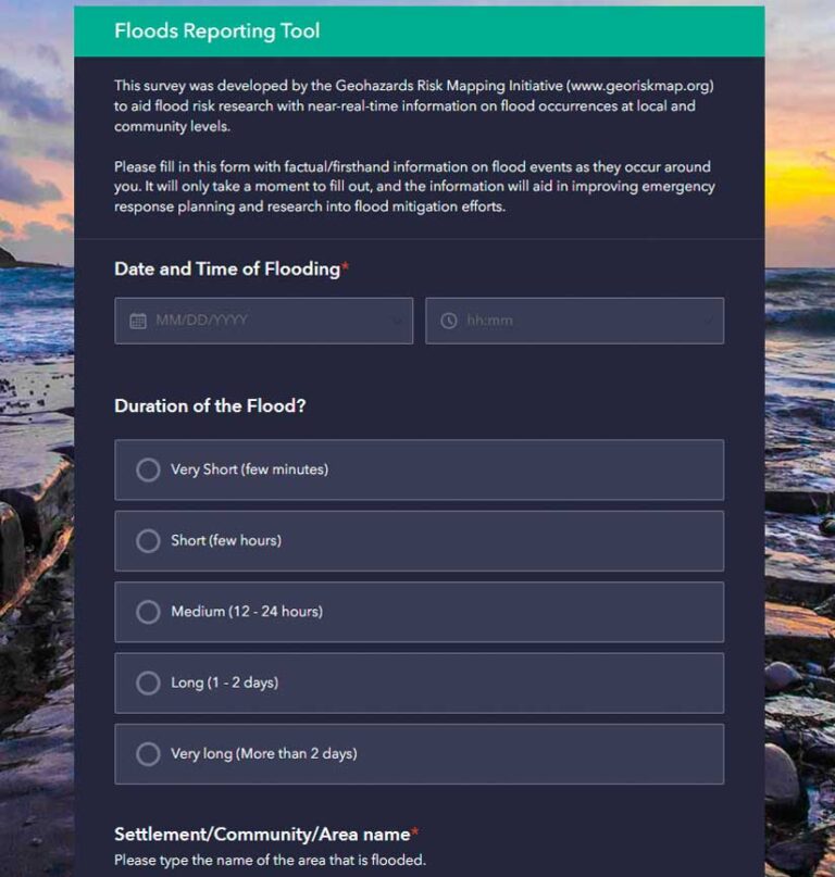
The geoportal also makes a variety of ArcGIS tools and tutorials available including ArcGIS Survey123. Using the form functionality of the Africa Geoportal, the GRMI team created a user-friendly flood reporting tool to capture data on flooding events in real time. This information is relayed to the national emergency agency, facilitating flood response in affected locations and contributing to a flood event database that can be used to mitigate future risks. Using this data and the analysis and mapping tools available from the Africa Geoportal, the team produces high-precision static maps and digital interactive flood susceptibility maps.
The Africa Geoportal’s capabilities for sharing allowed the maps and applications to be easily distributed to government institutions and local disaster management agencies and disseminated through various media platforms. Communities can interact with these maps and applications through a browser to better understand flooding risks and make appropriate preparations.
Helping Communities Be Better Prepared
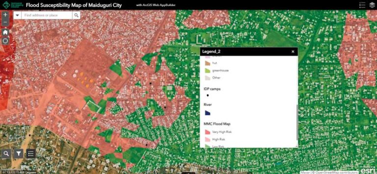
GRMI is making significant strides in mitigating the impact of floods in Nigeria, and this has benefited communities. Since its launch, GRMI has mapped 25 communities across different states in Nigeria, significantly improving disaster preparedness. The initiative’s efforts are making a tangible difference in underrepresented communities. For example, GRMI’s flood maps for the Maiduguri Local Government Area revealed various internally displaced camps that are at risk from future flooding.
The flood maps produced by the initiative have offered data that governments, communities, and individuals can use to better prepare for flood events. The maps GRMI produces reveal the level of flood susceptibility of farmlands, schools, and marketplaces. This information is crucial in initiating preventive measures and reducing the damage caused by flood events.
For example, educational institutions can now use these maps to improve their emergency preparedness strategies, ensuring students’ safety. Moreover, susceptibility maps guide the government and local planning agencies in making informed decisions about infrastructure development and land-use planning. GRMI’s user-friendly web app has significantly improved the flood reporting process in Nigeria, enabling real-time data sharing with national emergency agencies.
Call to Action and Next Steps
While GRMI has made great strides, there is still much to be done. The initiative is planning to convert its web app into a mobile app to enhance its accessibility and ease of use. However, this project requires additional funding. Stakeholders, which include governmental and nongovernmental organizations, need to provide the support necessary to realize this goal.
GRMI is continually looking for more volunteers who have skills in geospatial analysis and environmental management so it can assist more communities. Volunteering is a great opportunity for young professionals to gain practical experience and contribute to a project with significant societal impact. Members of Nigerian communities are encouraged to use the flood reporting web app and share it with others. Every report contributes to the comprehensive flood event database and helps provide crucial data that can save lives and properties.
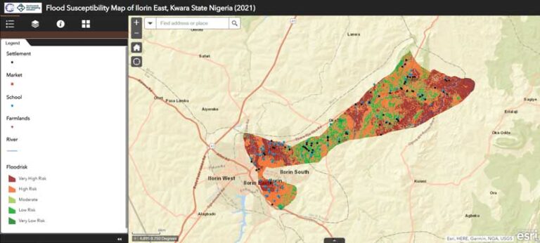
“The flood maps produced by Geohazard Risk Mapping Initiative were an absolute game changer for our climate action project,” according to Azeez Tobi Abubakar, Ilorin Climate Action Project lead, World Economic Forum Global Shapers Community, Ilorin Hub. “With their accurate and detailed mapping, we were able to better assess the communities that are susceptible to floods in Ilorin East and West Local Government Area of Kwara State, Nigeria. The maps guide our flood awareness campaign and other climate adaptation projects that we conducted in those communities.”
GRMI is a testament to the power of geospatial technology in addressing climate-change-related challenges. Through this initiative, Nigerian communities are better prepared to handle flooding, thereby reducing loss of life, property, and livelihoods. With additional support and resources, the initiative can continue to make an even more significant impact.