In his role as assistant director of spatial services, the author is responsible for space allocation and analysis and integrating GIS into campus operations. In this article he describes how his university is moving to ArcGIS Indoors.
The University of Rhode Island (URI), like so many other higher education research institutions relying on indirect cost rate agreements, has long utilized a computer-aided facilities management (CAFM) system to maintain the institution’s space database and floor plan library. Our current system is the INSITE suite of products including Net-FM and Visual-FM.
INSITE has developed into a system of record for other needs as well. The Facilities Group uses it to manage the physical campus, and it aids Property & Support Services in managing the moveable asset inventory. Public Safety relies on accurate and up-to-date data for emergency planning and response, while Environmental Health and Safety requires the data for inspections, abatements, and mitigations. Additionally, INSITE location and occupancy data feeds location data to other enterprise systems for work orders and faculty data tracking.
URI recently learned INSITE was being deprecated and a replacement was needed. It would be easy to say that URI considered ArcGIS Indoors based on a combination of existing GIS infrastructure and low licensing costs, but that would not tell the whole story.
Why ArcGIS Indoors?
Most CAFM systems are extremely useful to those who work in them daily. But how easy are they for others to use? We found that decision-makers relying on the CAFM data had difficulty interacting with the systems. As a result, CAFM operators spent too much time dumping data into spreadsheets or building reports and dashboards using third-party applications rather than focusing on data quality and creating new features. The data needs to be easier to retrieve, visualize, and analyze by decision-makers with less support from CAFM operators.
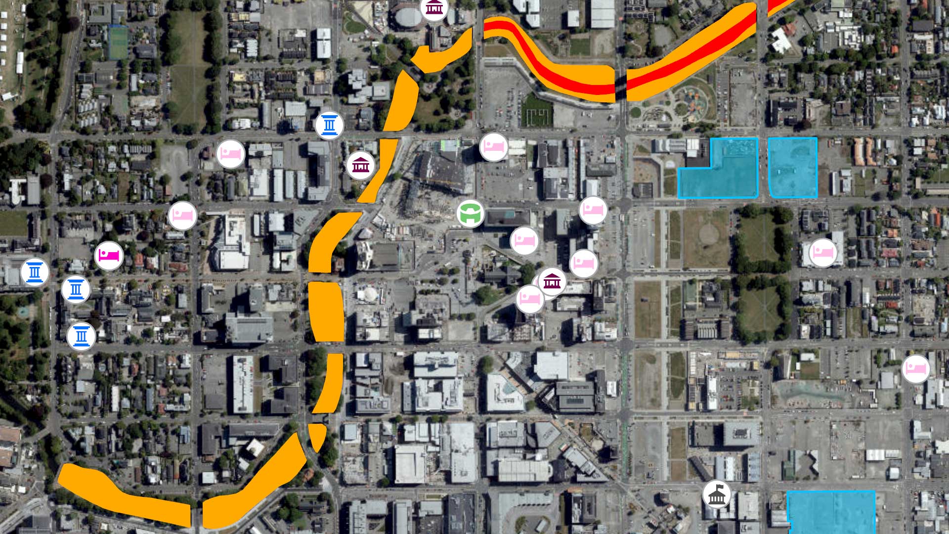
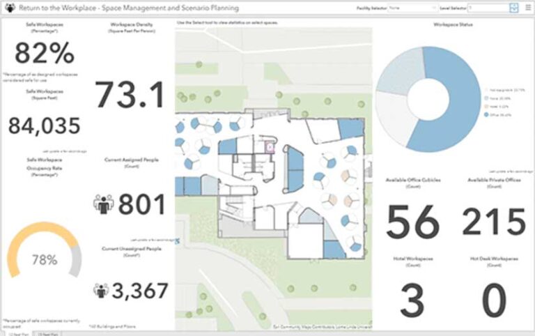
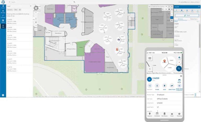
URI requires a system that also provides greater service to the campus community. Operationally, the campus community needs to track location data for multiple types of assets, collect data in the field, easily share data, and quickly develop systems of record for departments where none currently exist. At the same time, the university must meet the stringent system/data security requirements established by centralized IT. Also, faculty, staff, students, and guests want wayfinding assistance, room and workstation scheduling, and directory information—especially in a post-COVID-19 world.
ArcGIS Indoors, combined with existing products already licensed through our Esri educational agreement, gives URI these capabilities and more. In addition, the campus community will be able to access ArcGIS Indoors using a sleek graphic interface that is available on the desktop, the web, and mobile devices and through kiosk applications that are included with the license.
Also, GIS will now manage spatial data both inside and outside our facilities. Can another CAFM system provide an interface that lets users interact with floor plans, occupancy information, asset locations, and campus features outside the facilities while also providing scheduling capabilities with navigation from building to building or space to space? And—when considering future needs—ArcGIS Indoors brings URI closer to a true digital twin of the campus that is ready to integrate 3D data from Autodesk Revit, building information models (BIMs), and lidar.
Implementation Challenges
Sounds great, doesn’t it? It is, but there are going to be trade-offs. For starters, INSITE, like many other CAFM systems, is designed around the Postsecondary Education Facilities Inventory and Classification Manual (FICM). Establishing the space inventory in INSITE was straightforward, as preexisting tables contained the FICM major uses and associated codes.
Can ArcGIS Indoors handle tables like this? Yes, but the tables aren’t predefined. Modifications by our GIS staff will be needed to create attribute tables with the corresponding fields and domains. INSITE and other CAFM systems also offer a survey tool for conducting annual or ad hoc space surveys. We will be able to reproduce this functionality with either ArcGIS Field Maps or ArcGIS Survey123, but we will have to build the form and functionality from scratch.
On the asset side, INSITE handles many of the accounting functions for our moveable asset inventory including funding source, purchase order, and nomenclature for depreciation. While the asset feature class attribute table could contain some of these fields, URI is considering purchasing an accounting/inventory product that can manage the entire asset accounting life cycle including depreciation. Regardless, ArcGIS Indoors will be the system of record for space data and will feed the accounting system the location information used to identify where a moveable asset is located on campus.
Data Migration
The other challenge we face is the data migration from INSITE to ArcGIS Indoors, especially floor plan preparation. The Esri ArcGIS Indoors team has been a great resource for learning about how to prepare AutoCAD floor plans for ArcGIS Indoors. The team helped us understand the process, project scope, and data migration challenges.
However, URI utilizes INSITE’s floor plan editing software, Visual-FM. URI plans are not AutoCAD files, so URI created a workflow to manually convert the plans to AutoCAD files. But with 800 floor plans, URI is seeking a third party to handle the AutoCAD conversion using automated processes or scripting.
If you are not familiar with prepping floor plans for ArcGIS Indoors, the process typically includes some basic space data such as facility, floor, room name, and owner. Our CAFM system contains other important space attribute data such as office occupancy, research laboratory assignments, and space features. We needed a means to import the remaining data once ArcGIS Indoors was populated with the basic space inventory.
ArcGIS utilizes unique identifiers in the attribute tables and so do other databases. The INSITE space table includes unique IDs for each space. This space ID serves as a join for all the other related tables containing space attribute data and ties the attribute to the appropriate space.
These unique IDs are being copied to another field in INSITE that can be viewed on the floor plans through the INSITE floor plan editor in what is known as the INSITE space label. When the INSITE floor plans are converted to AutoCAD, the space ID will be included with the space label as it is transformed into an AutoCAD annotation. The annotation is then imported into ArcGIS Indoors when the floor plans are imported.
This will result in the ArcGIS Indoors space inventory containing the INSITE unique space ID. We can then utilize an Open Database Connectivity (ODBC) connection to transfer data from INSITE to related tables in ArcGIS Indoors by creating a join using the unique space ID as the common field. This will ensure that the INSITE space attributes are tied to the appropriate space in ArcGIS Indoors without manually editing each record. Once the data migration is complete, the INSITE unique space ID can be deleted from the ArcGIS Indoors data model.
The Bottom Line
Finally, let’s talk bottom line. What is this going to cost? Our annual licensing costs are being reduced significantly. We estimate the ArcGIS Indoors migration will reduce our annual CAFM costs by almost 70 percent. That’s after accounting for both the ArcGIS Indoors and AutoCAD licensing required to replace the INSITE suite of products.
Implementation costs are going to vary depending on current GIS infrastructure. Although we needed to upgrade our ArcGIS Enterprise instance, URI already has ArcGIS Enterprise in place and recently finished its first basemap. If you host your own data, both are critical to becoming ArcGIS Indoors ready. We anticipate the floor plan conversion and Esri professional support will cost approximately the same as one year of licensing costs for our current CAFM system.
If you are interested in learning more about ArcGIS Indoors. I would also encourage all higher education facilities managers to consider joining the Esri Smart Campus Operations community, which brings together like-minded colleagues and industry experts seeking to integrate Esri technology with campus and building data to understand the complex needs of campuses.
For more information, contact Jeff Ulricksen.
About the author