Technology Showcased at the Esri Developer Summit Will Inspire Software Developers to Make an Impact
GIS technology is quickly advancing in many new directions, benefiting developers in ways that will make a big impact on their work.
That was evident from the news that came out of the 2021 Esri Developer Summit (DevSummit).
For example, Esri announced the release of ArcGIS Enterprise on Kubernetes, which will give organizations a new way of delivering GIS using microservices.
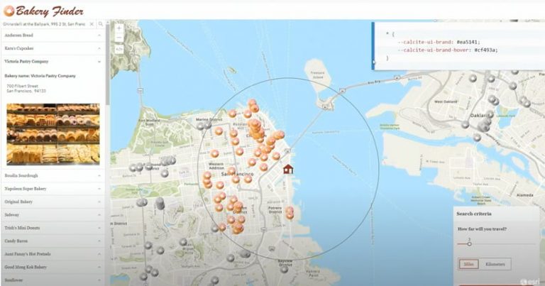
Esri also released ArcGIS Platform, a platform as a service (PaaS) product that provides software developers with mapping and location capabilities to integrate into their applications. Geospatial artificial intelligence capabilities are becoming highly sophisticated, as evidenced by this story from the City of Johns Creek in Georgia creating a tree inventory app with the help of deep learning capabilities available in the arcgis.learn module.
New 3D GIS capabilities in ArcGIS API for JavaScript were demonstrated during the DevSummit, including support for two extraterrestrial coordinate systems, giving developers the ability to create and visualize 3D scenes of Mars. And Esri opened up its Calcite, the Esri design system, to developers, providing them with the opportunity to give their apps a consistent look and feel.

More than 5,500 developers from more than 60 countries gathered virtually for the event, which was held April 6–8, 2021. Attendees received updates on Esri software and developer technologies during 60- to 120-minute Plenary Sessions held over three days. Technical sessions, including live and prerecorded content, also were held online. The virtual Ask Our Experts Showcase gave geospatial app developers the opportunity to get their technical questions answered by Esri staff. While Esri wants to bring DevSummit back to its usual venue in Palm Springs, California, in 2022, the mission remains the same whether people meet in person or online.
“This event is by developers, for developers,” said Jim McKinney, chief technology officer of desktop development at Esri, in welcoming attendees. “DevSummit is the largest gathering of geospatial developers on the planet, and you are a significant part of that. We are not only hoping to educate you but inspire you.”
Esri president Jack Dangermond joined McKinney for a few minutes to talk to the audience about the strong connection between Esri and the developer community, especially as Esri continues to redesign the developer experience. The aim: bring the power of mapping and location intelligence to all developers by making capabilities more accessible.
“The developer community…has been foundational to our success, and I appreciate, very much, the work that you do, this year particularly,” Dangermond said. In 2021 and beyond, Esri plans to build upon that foundation and develop closer ties with app developers.
“This is the year of opening up GIS to developers in a more amplified way,” said Dangermond, citing the release of new developer tools and services including the recently released platform as a service (PaaS) product ArcGIS Platform and the new deployment of ArcGIS Enterprise on Kubernetes.
Dangermond says he sees the important work developers are doing in areas such as public health, climate change, racial equity, and biodiversity. He noted one example: The work done by a team at Johns Hopkins University, which used ArcGIS technology to create a dashboard that mapped COVID-19 cases and deaths, globally.
“That whole gamut [of work] is so important, whether it’s putting a map in an app or building rich, science modeling tools that are looking at the future of our world and how to make it a better place,” Dangermond said. “Especially [important, are] you, the GIS developers, who bring the maps and the language of our world to life in various ways.”
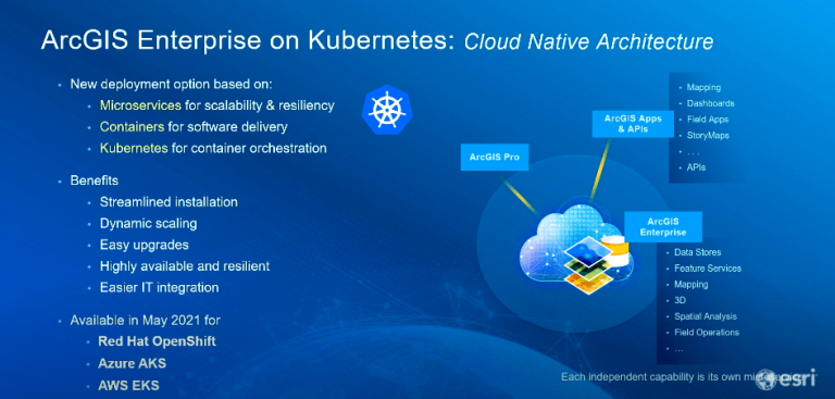
Esri Introduces ArcGIS Enterprise on Kubernetes
A major announcement made at the DevSummit this year was the release of ArcGIS Enterprise on Kubernetes.
Increasingly, applications are being built using containers or microservices to increase efficiency, scalability, and stability. Kubernetes is open-source software (originally designed by Google but now maintained by the Cloud Native Computing Foundation) that deploys, manages, and scales these types of containers or microservices.
“ArcGIS Enterprise on Kubernetes delivers GIS technology using cloud-native architecture,” Sud Menon, director of software product development at Esri, told the developer community during his DevSummit Plenary Session presentation. (Watch this video to see Menon’s complete overview of the ArcGIS system, including the release of ArcGIS Velocity, a cloud-native add-on capability for ArcGIS Online for ingesting real-time data and then analyzing it.)

In brief, ArcGIS Enterprise on Kubernetes is a new deployment option based on a microservices architecture for scalability and resilience, containers for delivering software, and Kubernetes for orchestrating the containers.
“Each independent capability such as hosted feature services or spatial analysis services is delivered as its own independently scalable microservice,” Menon said.
Menon pointed to the main benefits of ArcGIS Enterprise on Kubernetes as streamlined installation, dynamic scaling, easy upgrades that minimize downtime, higher resiliency, and easy IT integration.
Initially, ArcGIS Enterprise for Kubernetes is available for Red Hat OpenShift (an on-premises deployment option) and for Microsoft Azure Kubernetes Service (AKS) and Amazon Elastic Kubernetes Service (Amazon EKS) (managed Kubernetes services in the cloud deployment options.) Menon said that later in 2021, ArcGIS Enterprise on Kubernetes will be available for the Google Cloud Platform Google Kubernetes Engine (GKE).
Markus Walker, a product engineer at Esri, provides a demonstration on how to set up ArcGIS Enterprise on Kubernetes in this video presentation. And read this informative blog to get the answers to questions that developers asked about ArcGIS Enterprise on Kubernetes during DevSummit.

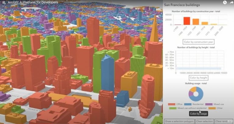
ArcGIS: A Platform for Developers
While current ArcGIS software users can already access location content, services, and capabilities using their ArcGIS software such as ArcGIS Enterprise, ArcGIS Pro, and ArcGIS Online, Esri released ArcGIS Platform to reach the wider software developer community.
ArcGIS Platform is a location platform as a service (PaaS) offering for software developers who want to integrate location capabilities into their apps, products, and business systems.
“It’s designed to bring powerful mapping and location capabilities as a set of independent services to you in the form that you are expecting,” said David Cardella, product manager of ArcGIS Platform. “These services have been powering ArcGIS for many years, but now we’ve opened them up in ways we haven’t before, and we are making them available to the global developer community.
ArcGIS Platform offers three main elements:
- An excellent developer experience with mapping APIs, open-source mapping libraries, and developer resources
- Location services that deliver extensive geographic content and capabilities
- A consumption-based business model that is simple, transparent, and easy to understand
Developers get access to the mapping library of their choice. It comes with ArcGIS API for JavaScript for creating web applications; a set of APIs for developing mobile and desktop applications; scripting APIs for automating mapping and analysis; and support for popular open-source mapping libraries including Leaflet, OpenLayers, and Mapbox GL JS.
“With the work we’ve done to enhance our back-end services, you will be able to use these libraries to access our location services in just a couple of lines of code,” Cardella said. “The choice of mapping libraries is yours, but regardless of the one you choose, you will be able to use location services from ArcGIS Platform.”
Cardella said that the location services available in ArcGIS Platform—such as basemaps, data hosting, data visualization, routing and directions, spatial analytics, geocoding and search, image analysis, and more—are now easier to access and integrate into solutions.
The business model is transparent and easy to understand, Cardella said, adding that developers will only pay for what services they use regardless of the API or authentication method they use.
Esri offers a free account to developers to help them get started using ArcGIS Platform. “You will receive a generous free tier to kick-start your development that includes two million map tiles and thousands of other service transactions [such as] searching, routing, or geocoding,” Cardella said.
To learn more about ArcGIS Platform, watch Cardella’s video presentation and read the ArcWatch article “Esri Introduces ArcGIS Platform.”
Building Apps Using Services from ArcGIS Platform
Euan Cameron, chief technology officer of developer technology at Esri, said developers have many options to choose from when they use services from ArcGIS Platform to build apps. These options include low code or no code options, APIs to build web applications, native and embedded applications, and applications built using game engines.
“We even have a design system to help you build beautiful looking apps,” Cameron said. This design system has CSS and JavaScript frameworks that include a set of web components that can be integrated into applications, design guidelines and graphic resources, and an interactive help system with great examples and documentation.
Julie Powell, principal product manager of web development technologies at Esri, said that the new design system from Esri creates a consistent look and experience among a suite of apps with its user interface (UI) components, colors, icons, and design patterns.
Esri is now sharing its design system with developers. “It’s called Calcite, and now we are making it available to all of you so you can use it in your web apps,” Powell said. “All you have to do is go to the [ArcGIS] Developers website, create an account, and you can start using it.”
The new Map Viewer in ArcGIS Online and ArcGIS Enterprise uses the Calcite design system for the user experience.
In her presentation, Powell showed the audience the library of UI components in the design system such as accordion, button, card, label, date picker, alerts, and more. “Because they are web components, you can use them with any JavaScript framework,” she said. “They are also flexible, so you can configure them for your particular use case. The part that I like the best is because they are responsive, they are designed to work on any form factor, so you have confidence when you build your application that it will adapt well to any screen size.”
The design system also comes with colors and themes. While the UI components default to the ArcGIS color palette, users can configure a color scheme that matches their organization’s branding. It’s also easy to switch from a light to a dark theme or vice versa by changing a single property. All the components then adjust accordingly to either the light or dark theme.
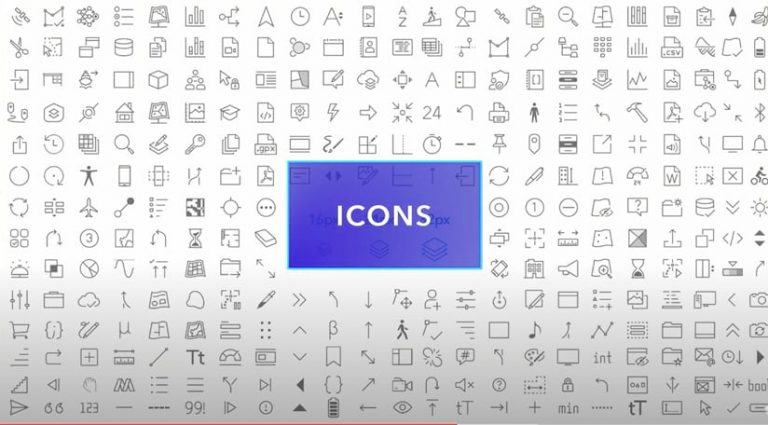
“There’s also 1,400 icons you can choose from,” Powell said. “This helps tell more of a visual story and simplify the text in your apps.”
Powell said the Calcite design system can help developers create consistency in all of their web apps. “You can seamlessly integrate with the ArcGIS ecosystem and, at the same time, highlight your brand and style,” she said.
Watch Powell’s Building Apps presentation.
New ArcGIS Map Viewer Debuts
Developers got to see the Calcite design system components in action during a demonstration of the new ArcGIS Map Viewer, which came out of beta in April.
Jeremy Bartley, group manager of ArcGIS API for JavaScript, demonstrated the viewer, which is available in ArcGIS Online and ArcGIS Enterprise. “Map Viewer is a good example of an application that’s completely built [using] the underlying technology within Esri, from ArcGIS API for JavaScript to the Calcite components to hosted feature services,” he said.
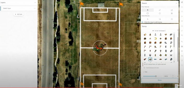
Bartley demonstrated several of the new and improved analysis, thematic mapping, and sketching tools that come with ArcGIS Map Viewer. It also comes with an improved and intuitive UI for creating web maps. There also are better pop-up configurations and labeling options, scale-driven styling, more printing layouts, reverse geocoding, new smart mapping styles, and new color ramps to better express data, including those that are color-blind friendly.
Watch Bartley’s entire ArcGIS Map Viewer presentation.
3D GIS Is out of This World
New 3D capabilities in ArcGIS API for JavaScript make many things possible, including creating 3D scenes of Mars.
Arno Fiva, a 3D developer evangelist for ArcGIS API for JavaScript, showed the DevSummit audience an application Esri developers created that supports two extraterrestrial coordinate systems. Other developers can use ArcGIS API for JavaScript in a similar way to create 3D scenes of the Martian landscape.
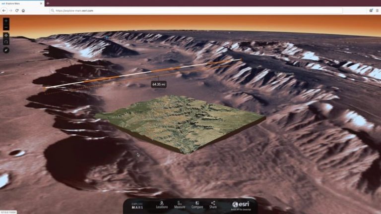
The Explore Mars app provides users with detailed elevation and imagery data for the whole planet. Fiva demonstrated how to use the app to zoom in to any location on Mars, such as craters and valleys or sites where Perseverance rover, Curiosity rover, and Opportunity rover landed. The app comes with line, area, and elevation measurement tools and tools to compare areas on Mars with 3D models of cities such as Zurich, Switzerland, natural features such as the Grand Canyon, or any region of Earth. For example, if you want to see how much of an area Sudan in Africa would take up on Mars, you just click on Sudan in a globe and click “Place it on Mars.”
Watch Fiva’s entire presentation.
The New Data Engineering Experience
New tools in the May 2021 release of ArcGIS Pro 2.8 will make data engineering, a highly time-consuming aspect of the spatial analysis process, much easier, according to Lauren Bennett, who leads the spatial analysis and data science software development team at Esri.
Data engineering—getting the data ready for analysis by adding new fields or filling missing values—is crucial, according to Bennett. “Our analysis is only ever as good as the data that we put into it,” she said.

With the release of ArcGIS Pro 2.8 will come a new data engineering experience that will make exploring and visualizing data easier. Tools that are in the ArcGIS system will be brought together to construct, clean, format, and integrate data to prepare it for analysis, according to Bennett.
Esri solution engineer Lakeisha Coleman demonstrated this new capability using data from the Supplemental Nutrition Assistance Program (SNAP) and demographic and unemployment data. Watch this video to see how Coleman streamlines the data engineering process with the new tools that were released in May.
As McKinney said during the Plenary Session, the hope is to educate and inspire.
“You have a great set of tools and developer technologies for yourself, your customers, or your enterprise,” he said. “Let’s stay connected through the Esri Community. We look forward to hearing from you!”
The following videos will give you added insights into the new capabilities demonstrated during the DevSummit.
Search, Route, Navigate, Collect Data
2D/3D Mapping and Visualization
ArcGIS and Game Engines: CIMIC Group
ArcGIS Image for ArcGIS Online
Multidimensional Change Detection
Analytics Overview: Big Data Analysis with GeoAnalytics
ArcGIS Enterprise on Kubernetes—Automated Maintenance
ArcGIS Enterprise on Kubernetes—Automate Scaling and Operating Your System
Advancements in Spatial Analytics: Time-Series Forecasting
Real-Time Analysis with ArcGIS Velocity
AI User Story: Road Extraction by Public Authority for Civil Information (PACI)
AI User Story: Extracting Railway Assets from Lidar from L&T
Object Tracking in Full Motion Video Using AI
AI User Story: Integrated Mesh Scenes by Systematics
Extending and Automating Your Enterprise
