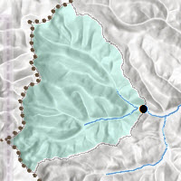
 The Esri Hydro Team is pleased to announce it has added more data layers to the Living Atlas.
- USA Polluted Waters (Source: EPA 303d)
- USA Permitted Point Source Water Pollution (Source: EPA NPDES)
- USA Hydrologic Group Code (Source: SSURGO)
In addition, our Hydrology analysis services (Watershed and Trace Downstream) have a new URL: hydro.arcgis.com.
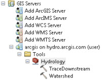
In order to connect to the Hydrology analysis services in ArcGIS Desktop, you need to create an ArcGIS Server connection in the GIS Servers folder:
The URL to create this connection is http://hydro.arcgis.com/arcgis/services. You will also need to provide your ArcGIS Online organizational account credentials.
If you are using ArcGIS 10.2.1 or later, and were accessing the Hydrology analysis services through the Ready-To-Use Services link in the ArcCatalog window, you may have noticed that the Hydrology tools stopped working recently due to this URL change. The link to these tools through the Ready-To-Use folder will be fixed in the upcoming ArcGIS 10.3 release. Until then you can continue to use these services by adding the server as described above.


Article Discussion: