Good news, everyone! ArcGIS Enterprise 10.9.1, part of the ArcGIS 2021 Q4 release, is here on Windows and Linux and is available to all eligible customers worldwide. This long-term support release builds upon what was introduced in 10.9, with new enhancements, features, and functionality.
This blog will cover the highlights of this release across the Enterprise portal, content and data management, administration, and more. For a comprehensive view into everything included with this release, take a look at the What’s new in ArcGIS Enterprise help topic in the product documentation. In addition, keep a look out on the ArcGIS Blog site for additional articles covering specific features in depth.
ArcGIS Enterprise portal
New Map Viewer
The new Map Viewer, formerly known as the Map Viewer Beta, was introduced last year as a separate install with ArcGIS Enterprise 10.8.1 and 10.9. With this latest release of ArcGIS Enterprise, the new Map Viewer comes installed with ArcGIS Enterprise. The Map Viewer comes with enhancements in its interface, the ability to create apps directly from the app, and additional layer support. More information on this may be found in this blog: New Map Viewer in General Availability. You will still have access to the classic Map Viewer and can set either the new Map Viewer or Map Viewer Classic as the default for your organization.
Add members through a template
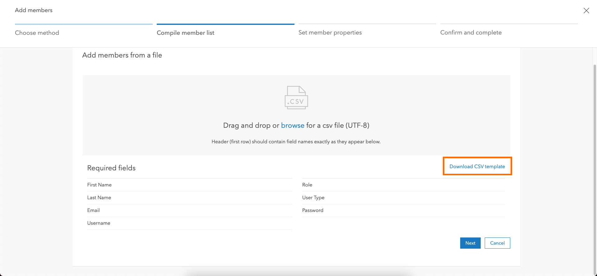
If you’re an ArcGIS Enterprise administrator adding new members through a CSV file, you may have spent some time making sure the file was properly formatted and contained all the necessary fields. GIS administrators rejoice! This is no longer an issue at this latest release of Enterprise. The Enterprise portal now includes the ability to download a CSV file to serve as a template when adding members. It will come already populated, in the language specified in the Enterprise portal, making it that much easier for you to add new members!
New organization home page options
A new homepage editing experience was added to in ArcGIS Enterprise 10.9. ArcGIS Enterprise 10.9.1 enhances this capability. You can now have color and typography options. These options allows you to choose and apply a color scheme and font family to your page. For more information on this, see the Configure home page section of our product documentation.
Updates to distributed collaboration
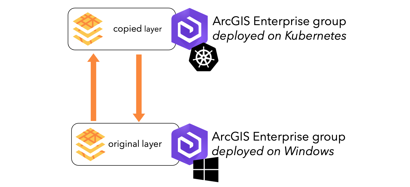
ArcGIS Enterprise 10.9.1 organizations on Windows or Linux now supports distributed collaboration with ArcGIS Enterprise for Kubernetes 10.9.1, as either guest or host participant. Prior to this, ArcGIS Enterprise on Kubernetes could not patriciate in a collaboration with an ArcGIS Enterprise organization in a Windows or Linux environment.
Content and data management
Cloud Data Warehouse Support
The ability to consume data from cloud data warehouses is something many of you have been asking for. We have heard you! ArcGIS Pro 2.9 and ArcGIS Enterprise 10.9.1 include support for cloud data warehouses.
In ArcGIS Pro, a connection can be made to Amazon Redshift, Google BigQuery, or Snowflake. The data can be consumed directly from the cloud data warehouse, as a query layer, or with feature binning enabled. For more information on what you can do with cloud data warehouses in ArcGIS Pro, see the Supported databases and cloud data warehouses section of the product documentation.
From ArcGIS Pro, the data from the cloud data warehouse can be shared as a map image layer to ArcGIS Enterprise. The cloud data warehouse must be registered with ArcGIS Enterprise as a registered data store. Once registered, the map image layer can be published to the hosting server. This map service can be published in one of three ways:
- Accessing data directly. This means the data will be accessed directly in the cloud data warehouse. This can be costly and is not recommended unless you have a specific workflow that requires this.
- Snapshot. This means that when the map image layer is published, the data is copied into the ArcGIS Data Store’s relational data store – this doesn’t mean it’s a hosted service. It’s just a referenced service that is referencing data in the ArcGIS Data Store. The data can be updated on demand through the Enterprise portal.
- Materialized view. This means the data will be accessed directly in the cloud data warehouse but, unlike accessing the data directly, it will only be updated periodically – depending on how the connection to the cloud data warehouse is configured.
For more information about cloud data warehouse support and ArcGIS Enterprise, see our New in ArcGIS Enterprise 10.9.1: cloud data warehouse support blog.
New experience for adding content
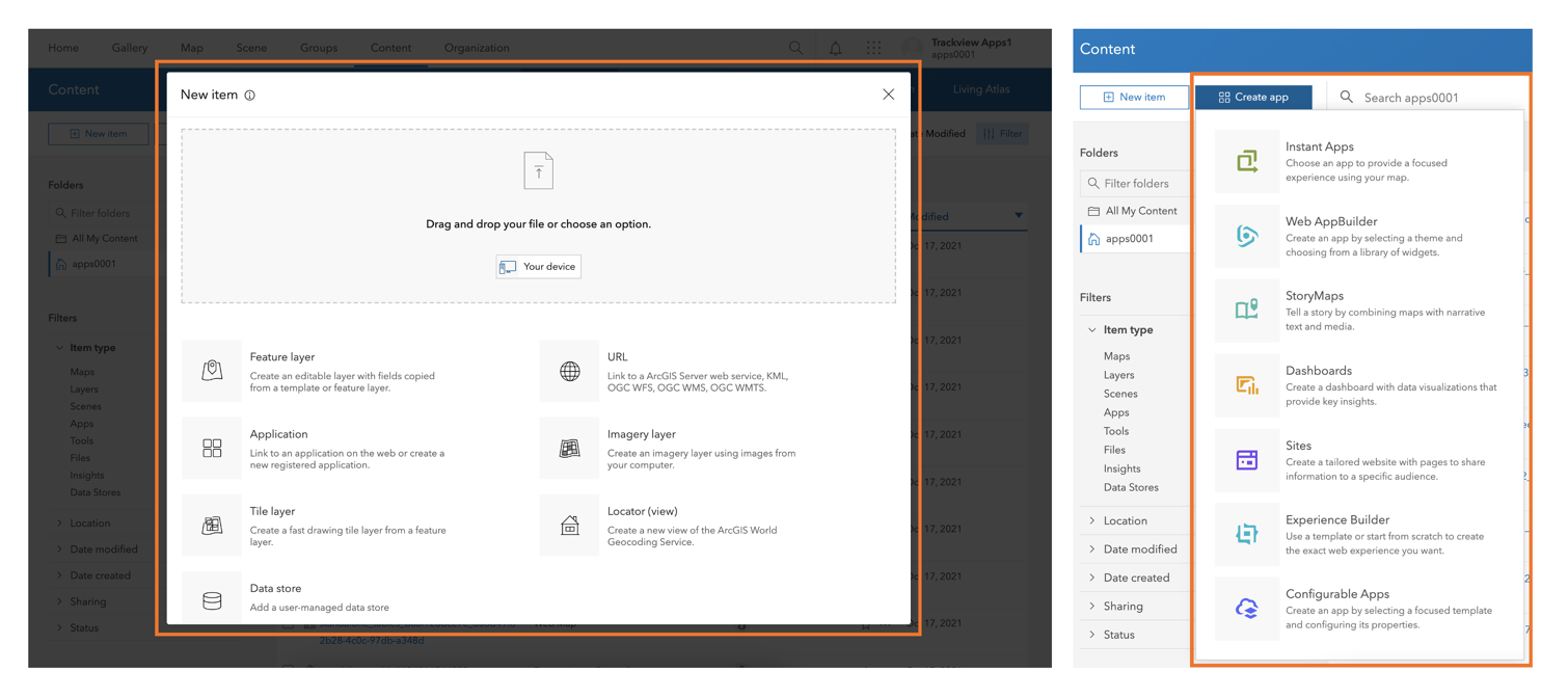
When adding content to your organization, you may notice that there’s a new experience to do this. You will see this on the Content page, with the appearance of the New item and Create app buttons. Clicking New Item, you will see a new user interface for anything you want to add, from file-based items like shapefiles and CSV files, to URLs that reference layers already on the web, like ArcGIS Server and OGC services. There is now also drag-and-drop functionality, allowing you to add content directly from your desktop.
Clicking on Create app will list all the applications you have access to creating. Here you’ll also notice a new application, Instant Apps, with an express mode that lets you build apps quickly with common settings and a full setup mode to select and configure all additional tools. The list of applications you here see depends on the role you have within the organization and any add-on licenses assigned to you.
For more information on the new user experience for adding content in the Enterprise portal, see Mike Minami’s blog A new way to add content to ArcGIS Online (June 2021).
Google Cloud support
This latest release of ArcGIS Enterprise includes many new features related to Google Cloud support. ArcGIS Enterprise now supports Google Cloud SQL for PostgreSQL and Google Cloud SQL for SQL Server. There is also support for Google cloud storage for caching and image service workflows, as well as support for cloud data store items that access locations in Google cloud.
Stay tuned for a separate blog article regarding more information on Google Cloud support and ArcGIS Enterprise.
Administration
Faster installation time for Portal for ArcGIS
When installing or upgrading to this latest release of ArcGIS Enterprise, you may notice the Portal for ArcGIS component doesn’t take as long as it has in the past. This is because enhancements have been made to the Portal for ArcGIS installer – meaning you can expect faster installation and upgrade performance.
Enhancements to migrating services to the ArcGIS Pro-based runtime
To help you prepare for future releases of ArcGIS Enterprise, at 10.9 we included migration tooling to help you migrate your services from the ArcMap-based runtime to the ArcGIS Pro-based runtime. This migration tooling came in two different forms:
- Edit Runtime operation
- UpdateArcMapServices utility
For more information on these migration tools, see our Migrating services to the ArcGIS Pro-based runtime in ArcGIS Enterprise 10.9 blog.
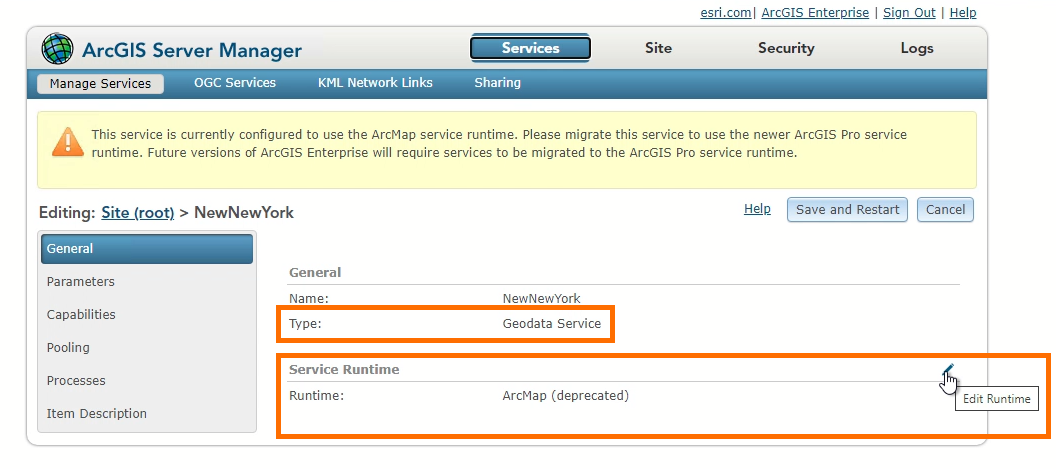
ArcGIS Enterprise 10.9.1 builds upon these migration tools introduced earlier this year. Using the Edit Runtime Operation or UpdateArcMapServices utility, you can now migrate geodata services from the ArcMap-based to the ArcGIS Pro-based runtime. The Edit Runtime operation now also includes the ability to migrate image services from the ArcMap-based to the ArcGIS Pro-based runtime; in 10.9, this is something that could only be done with the UpdateArcMapServices utility.
Optional ArcMap Service runtime for ArcGIS Server
This release of ArcGIS Enterprise includes the option to disable the ArcMap Runtime Support feature in ArcGIS Server. This feature enables the ability to publish and consume services published from ArcMap; with the ArcMap Runtime Support comes an installation of Python 2.x. The Runtime Support feature can be disabled when installing or upgrading ArcGIS Server to 10.9.1. The feature can also be enabled or disabled after installing or upgrading ArcGIS Server.
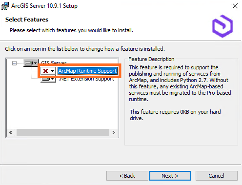
For more information on how to disable or enable the ArcMap Runtime feature, see the ArcGIS Enterprise documentation.
If your organization has concerns about having Python 2.x on your system, disabling this feature will ensure that Python 2.x is not installed with ArcGIS Server. This option should be considered if an organization has security protocols in place in which Python 2.7 can no longer be installed or if you are ready to make the move to the ArcGIS Pro-based runtime.
Learn more about the optional ArcMap Service runtime for ArcGIS Server in our ArcMap Runtime Support: to disable or not to disable? blog.
Email notifications for low disk space
If your ArcGIS Enterprise is configured for email notifications from the Enterprise portal, this release introduces email notifications to be sent when the ArcGIS Server and ArcGIS Data Store machines reach critical disk space thresholds.

These emails will go out daily to the administrative contacts set within the organization when there is less than 10GB of usable disk space remaining. For the ArcGIS Data Store, an email will also be sent out to the same administrators when the data store is put into read-only mode. For more information on configuring email settings, see the ArcGIS Enterprise documentation.
Diskcleanup utility in ArcGIS Data Store
This release of ArcGIS Enterprise includes the diskcleanup utility with ArcGIS Data Store. This utility can be used with relational, tile cache, and spatiotemporal big data stores.
The diskcleanup utility removes temporary files left over from operations such as restoredatastore and upgrading ArcGIS Data Store. Once you confirm your upgrade or restore operation is successful and the system is working as expected, you can run this tool to remove those temporary files and regain free disk space on the data store machines.
Apps
ArcGIS Instant Apps updates
We introduced ArcGIS Instant Apps in ArcGIS Enterprise 10.9, enabling you to quickly create web apps directly from your web maps. At ArcGIS Enterprise 10.9.1, ArcGIS Instant Apps have been enhanced so you can now search through app capabilities to find an app template and create an app from your Content page or the map item page directly. ArcGIS Instant Apps now also includes an exciting set of new updates, including the new Portfolio template and updates to the Nearby template. More on this can be found here in Krista McPherson’s Introducing ArcGIS Instant Apps blog.
ArcGIS Dashboards
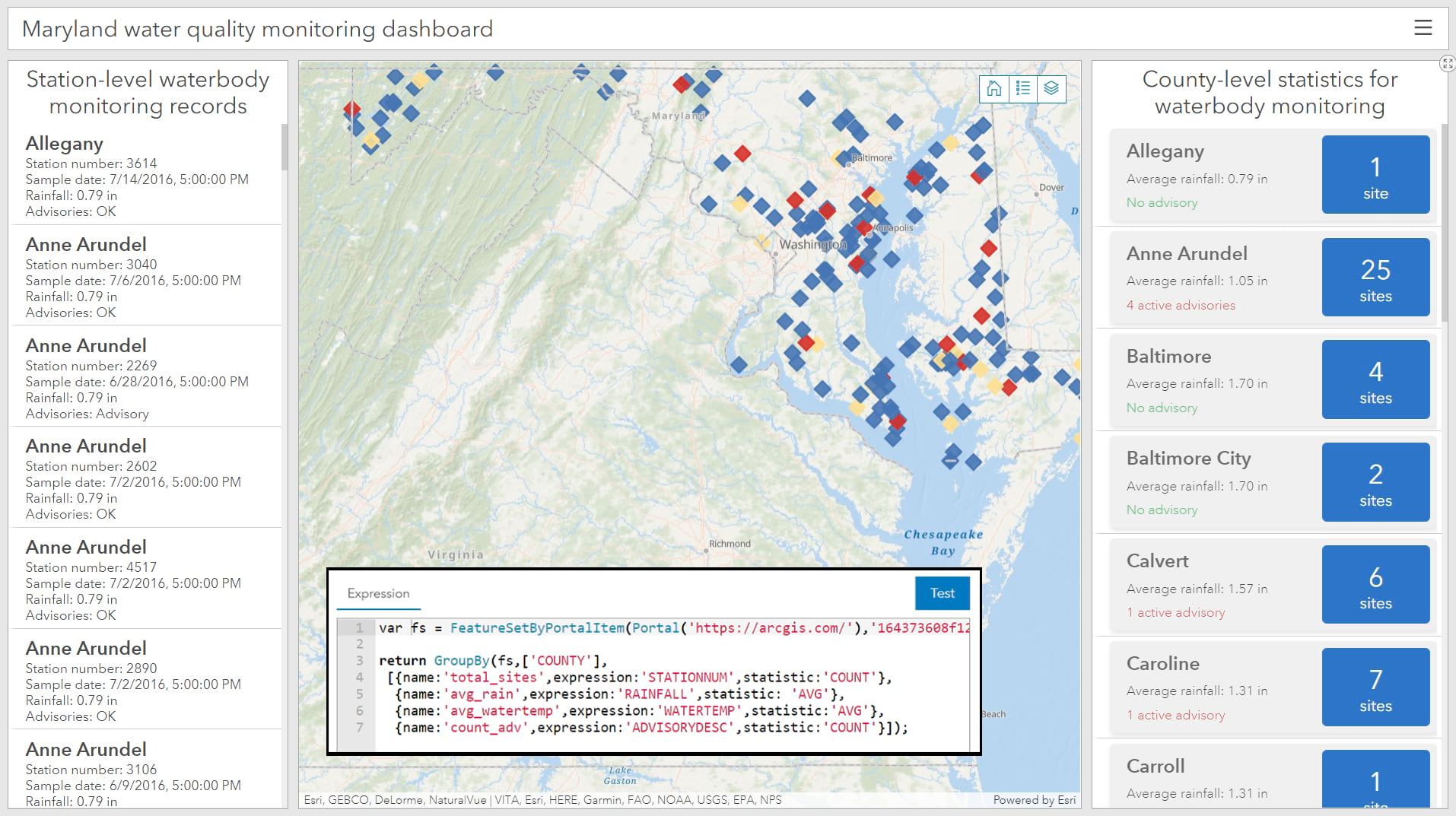
This latest release of ArcGIS Enterprise also includes the next generation of ArcGIS Dashboards, built with ArcGIS API for JavaScript 4.x. The new ArcGIS Dashboards can support the same workflows as Dashboards Classic, including mission-critical projects but is also more performant. It also includes important enhancements such as: Data expressions, advanced formatting using Arcade, and Selection-based displays. More information on the new ArcGIS Dashboards can be found in Julia Shi’s New ArcGIS Dashboards is out of Beta blog.
ArcGIS Enterprise Sites updates
Last, but not least, to wrap up the Apps section of this blog article, is ArcGIS Enterprise Sites. ArcGIS Enterprise Sites enable users to create professional looking web pages that utilize your ArcGIS Enterprise GIS content. New features in Enterprise Sites include: enhancements to viewing new content pages for items shared through a site’s search catalog, the API explorer being available on the side panel for datasets that have an exposed API endpoint, and the ability to enable one click sharing of sites to social media. For more information on what’s new in ArcGIS Enterprise Sites, take a look at the product documentation.
ArcGIS Enterprise server roles
ArcGIS GeoAnalytics Server
Enhancements to GeoAnalytics Server at this release include adding and enhancing analysis tools and improving the user experience with big data file shares. The new Group by proximity tool considers a feature’s spatial or temporal proximity to other features, and groups them accordingly. The Summarize within tool now supports standard deviation and variance output weighted statistics. Big Data file shares can now be added through the New item context menu in the Enterprise portal. Once the file share is added, you can update its underlying properties such as the schema of the data, time format, and geometry types. For a comprehensive list of all the new features in the release, check out the What’s new in ArcGIS GeoAnalytics Server help topic.
ArcGIS GeoEvent Server
ArcGIS GeoEvent Server 10.9.1 includes enhancements to its backend libraries and dependencies. Special attention has been paid to optimizing dynamic geofences. Importing geofences can now be controlled via a query. This enables admins to specify the exact geofences they need from a feature layer, instead of importing the entire feature layer. For comprehensive list of all the new features in the release, check out the What’s new in ArcGIS GeoEvent Server help topic.
ArcGIS Image Server
This release of ArcGIS Image Server includes improvements for supporting server-side processing in ArcGIS Pro. If Image Server is configured with ArcGIS Enterprise, server-based raster analysis tools can be used in ArcGIS Pro. This includes using the Suitability Modeler with ArcGIS Pro as a client. The ArcGIS Ortho Maker app now supports creating products in batch mode after creating the project. The product can be downloaded as GeoTiffs, and batch processing will be utilized to optimize project creation or adding new flights to a project. Last, but certainly not least, an Image Server can be configured for Raster Analysis when running on Linux. For a comprehensive list of all the new features in the release, check out the What’s new in ArcGIS Image Server help topic.
ArcGIS Notebook Server
In this release of ArcGIS Notebook Server, notebooks can now be executed when a webhook is triggered. Administrators can now configure webhooks to monitor their ArcGIS Enterprise organization. For example, an administrator may want to keep an eye on how many new users are being added to their Enterprise portal organization. They can configure a webhook to monitor the number Enterprise portal members as they relate to available licenses. If the number exceeds a known number of available licenses for add on applications, the webhook can trigger a notebook to send emails to a list of specified contacts, as well as a variety of other actions.
Another new feature in this release is the ability to publish notebooks as web tools. For a comprehensive list of all the new features in the release, check out the What’s new in ArcGIS Notebook Server help topic.
ArcGIS Knowledge
ArcGIS Enterprise 10.9.1 includes a new product: ArcGIS Knowledge, which allows you to create a knowledge graph in ArcGIS Enterprise with ArcGIS Pro. A knowledge graph allows you to construct a model that simulates a real-world system. Knowledge leverages the new ArcGIS Knowledge Server role and includes a new ArcGIS Data Store type: the graph store. To read more about ArcGIS Knowledge, look at the Introducing ArcGIS Knowledge: What’s Coming (November 2021) blog article.
Learn more
And those are the highlights of what’s new in this latest release of ArcGIS Enterprise! For a comprehensive look at everything included in this release visit the What’s new in ArcGIS Enterprise help topic and associated subtopics in the product documentation.
Ready to get started? Head over to the My Esri website for your licenses and software. Enjoy!


Article Discussion: