The world is rapidly becoming urbanized, putting intense stress on cities to expand quickly and sustainably. A recent article of the United Nations predicted that by 2050, 68 percent of the world’s population—2.5 billion people—will live in urban areas. While cities are getting more densely populated, bigger challenges lie ahead in terms of urban planning and design. Topics such as impact assessment, site analysis, and visibility analysis are among them.

Visibility analysis is a fundamental yet remarkable aspect of urban planning. As the term implies, visibility analysis computes and analyzes the visibility of one or more objects in terrain or space for given observer points. Line of sight and viewshed are two of the most frequently used tools for visibility analysis:
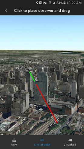
- Line of sight—Draws a line between the observer point and the target point to indicate the visibility (visible or obstructed) along the line between the given points.
- Viewshed—Indicates the visibility (visible or obstructed) of an area from a specified viewpoint.
Interactive, Dynamic, and Efficient
Interactive analysis provides a brand-new experience of performing 3D analysis by interactively adjusting parameters and visualizing on-screen feedback while conducting visual assessments. Unlike the geoprocessing workflow, interactive 3D analysis in ArcGIS Earth is exploratory and provides immediate results on the fly while you are clicking in the scene.

With ArcGIS Earth, you can interactively add, edit, and visualize line of sight or viewshed analysis results that are calculated against the current contents displayed in the 3D scene. There are multiple approaches for performing line of sight analysis and viewshed analysis. Specifically, you can indicate observers by clicking in the scene to place a marker, or simply use the current camera position as the observation perspective.

To simulate real-world experiences to the fullest extent, ArcGIS Earth also supports conducting visibility analysis with 3D animations by having the observer dynamically move along a specified path.
Interactive analysis tools for planners
Here are some examples of how interactive analysis tools in ArcGIS Earth can be used in urban planning:
- Estimating visibility of existing landmarks for city planning
- Evaluating the visual impacts of a landscape for city expansion
- Controlling risk and assessing threats for crucial activities or events
- Analyzing construction spaces in civil engineering
- Briefing or communicating progress upward and downward
Read more about the visibility tools from Learn ArcGIS. If you haven’t tried these fantastic capabilities, download ArcGIS Earth for free and get started now.
You can also perform interactive 3D analysis in the mobile platform with ArcGIS Earth. Download ArcGIS Earth for Android from Early Adopter or Google Play, or download ArcGIS Earth for iOS from TestFlight.

Commenting is not enabled for this article.