ArcGIS Enterprise is being turned up to 11! We are excited to announce ArcGIS Enterprise 11.0, part of the ArcGIS 2022 Q2 releases, is now available to all eligible customers worldwide. This release is full of new enhancements and functionality. This release will be the first time we have increased the major version number of ArcGIS Server, now part of ArcGIS Enterprise, in over 10 years. We are moving to ArcGIS Enterprise 11.0 because of the significant under-the-hood changes in technology for our Windows and Linux deployment options.
This blog will cover the highlights of this release across ArcGIS Enterprise: in the Enterprise portal, content and data management, administration, apps, much more. This blog will also outline other changes to be aware of in ArcGIS Enterprise 11.0.
For a comprehensive view into everything included with this release, look at the documentation available in the What’s New in ArcGIS Enterprise help topic. The ArcGIS blog site will also provide additional blogs covering specific features, including a blog about new beta features coming ArcGIS Enterprise 11.0.
ArcGIS Enterprise portal
Map Viewer updates
Map Viewer was introduced last year in ArcGIS Enterprise 10.9.1. With this latest release of ArcGIS Enterprise, Map Viewer includes enhancements in its interface and new functionalities. Map Viewer Classic is still available for use in ArcGIS Enterprise 11.0 but is no longer the default for creating web maps in your organization.

Map Viewer highlights include:
- New layer effects. The new layer effects available allow you to add dramatic visual effects to the layers in your map. With new effects such as drop shadow, bloom, and blur, you can add cartographic touches to your map that give prominence to overlapping features (bloom), communicate fuzzy boundaries (blur), and much more.
- Pop-up improvements. New pop-up improvements enhance the existing pop-ups functionality in Map Viewer. Users can create custom information displays by editing and displaying HTML in pop-ups. Map Viewer now also includes enhanced imagery layer support including the ability to configure pop-ups and apply raster function templates.
- Sketch enhancements. Map Viewer at ArcGIS Enterprise 11.0 contains enhancements to sketch layers, which allow users to interactively add features to their maps such as stamps, lines, polygons, rectangles, circles, and text. Descriptive information can also be added to features which will appear within pop-ups.
- Create charts. There is now support for four new chart types: bar charts, line charts, scatter plots, and histograms to help uncover patterns, trends, and relationships in your data.
For more information about what’s new in Map Viewer in this release of ArcGIS Enterprise, see our What’s New in Map Viewer (September 2021), What’s New in Map Viewer (December 2021), and What’s New in Map Viewer (March 2022) blogs, which cover the details of these new features as they were introduced into ArcGIS Online.
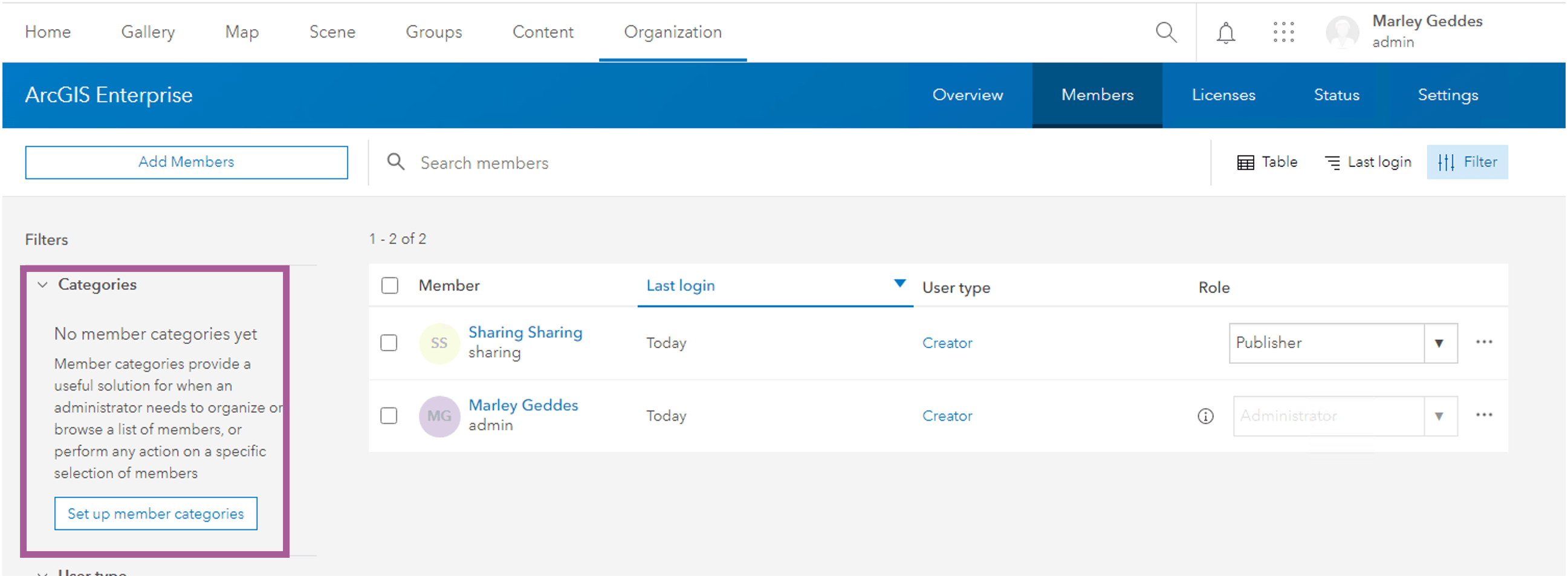
Hierarchical categories for Enterprise portal members
Hierarchical categories are member categories that allow administrators to organize members of their organization by various characteristics. ArcGIS Enterprise administrators can now set up hierarchical categories to group members by categories such as department, location, and expertise. Once these hierarchical categories are configured, administrators and members with the correct privileges can filter the list of members by member category which are also displayed on the member’s user settings page. This categorization further helps organizations ensure members are seeing relevant information and eases privilege management work for administrators.
New member privileges: reassign content and receive content
There are two new member privileges in ArcGIS Enterprise 11.0: reassign content and receive content. These new privileges allow organization members to transfer content amongst other members of their organization. Organization members can reassign content they own to other members without requiring an administrator to perform the change. Having these new privileges puts more power into individual members’ hands, minimizing privilege changes that require administrators to be involved.
Esri Raster basemaps are in mature support
Several Esri raster basemaps have moved to mature support and will no longer be updated. We recommend that customers running versions of ArcGIS Enterprise supporting Esri vector basemaps switch to using vector basemaps by default. Retired basemaps will be marked with a “Deprecated” badge on the item details page.
New installations of ArcGIS Enterprise 11.0 will have Esri vector basemaps configured by default and there will be no means for customers with new installs to switch to using Esri raster basemaps. For customers upgrading to ArcGIS Enterprise 11.0 with Esri raster basemaps already configured, those basemaps will remain configured following the upgrade.
Content and data management
New features for managing content in the Enterprise portal
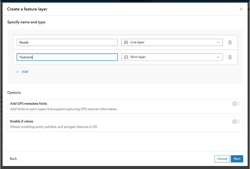
Within the ArcGIS Enterprise portal, you may notice some new workflows when working with features layers. There is an enhanced experience for creating new feature layers when creating new content in this release. After creating a blank layer, you can immediately add multiple features of different types including point, line, polygon, or table.
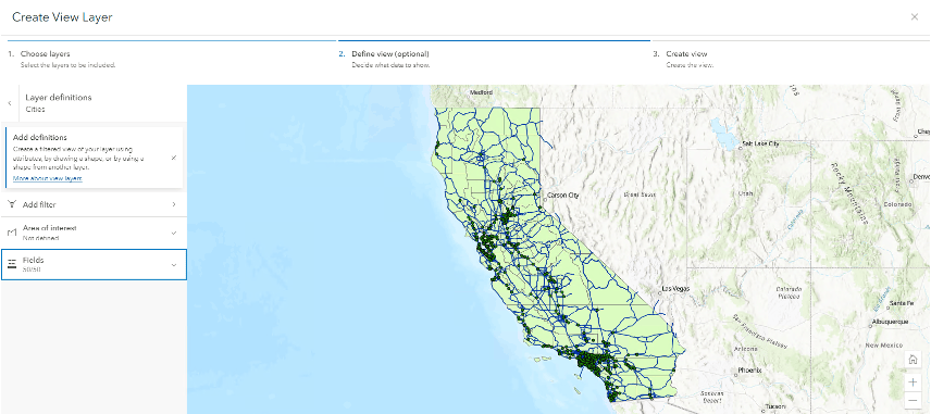
There is also new and improved user experience for creating view layers from hosted feature layers whether from relational or spatiotemporal data stores.
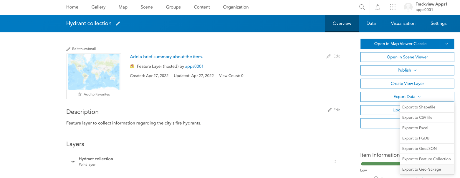
This release brings new features for geopackages. Users can now publish a geopackage as a hosted feature layer. Through the Item Details page, a geopackage can now also be exported from a hosted feature layer.
Lastly, users can enable OGC API – Features support on feature services with referenced data. This is in addition to the long-standing support for the OGC WFS specification.
Updates to the create tile and publishing scene layer experiences
The create tile layer functionality has an updated, allowing users to now use the “New item” button to add a tile layer. From here, users can publish raster and vector tile layers. This new option will display when:
- Uploading a package (.vtpk or .tpkx)
- Uploading a SD
- Using tile content in ArcGIS Data Store
- Using a feature layer
The publishing scene layer similarly has been updated. Using the “New Item”>”Scene layer” buttons, user will see this new option will display when:
- Uploading a package (.vtpk or .tpkx)
- Using tile content in ArcGIS Enterprise Data Store
Resampling tile layer
Resampling tile layers allows for more efficient caching for user. Users generating tile layers using map or image data may choose not to generate caches for sparsely visited areas or detailed scales in order to save time and disk space. When users pan or zooms to these areas, no content is rendered due to the lack of availability of cached tiles. Enabling resampling in ArcGIS Enterprise 11.0 on these layers helps user to render content using existing caches at lower levels to fill in these gaps for other users.
Response caching
Response caching is a backend server caching mechanism, through the object store, that significantly increases performance and scalability for data server from hosted feature services stored in the ArcGIS Data Store’s relational data store. It is ideal for data that is changed infrequently or for read-only data.
Ability to publish geodata services from ArcGIS Pro
Geodata services can now be published from ArcGIS Pro 3.0 to ArcGIS Enterprise 11.0. This is an important feature if your organization uses geodata services and you’re ready to move to the ArcGIS Pro-based runtime. Previously, geodata services could only be published from ArcMap and had to be migrated to the ArcGIS Pro-based runtime using the migration tooling in ArcGIS Enterprise 10.9.1.
Updates to cloud data warehouse support
Support for cloud data warehouses was introduced in ArcGIS Enterprise 10.9.1. ArcGIS Enterprise 11.0 builds upon this by introducing the ability to publish read-only feature services from Google BigQuery. There are also two new bin types with feature binning: geohex and geosquare. For Amazon Redshift, feature binning now supports the geohash bin type.
Service webhooks (beta feature)
ArcGIS Enterprise originally introduced webhooks several releases ago to track events for many types of portal-level actions such as user, item, and group related operations. At ArcGIS Enterprise 11.0, webhooks for feature service events for create, read, update, and delete (CRUD) operations for referenced and hosted services are available as a beta feature. Geoprocessing service webhooks are also available for job statuses on asynchronous services.
Service webhooks are a beta feature in ArcGIS Enterprise 11.0, meaning the support and recommendations for the feature are different than those for features in general availability. Read more on what it means for a final release of ArcGIS Enterprise to contain a feature in “beta” in our Beta Features in ArcGIS Enterprise 11.0 blog. This blog includes instructions for accessing the Early Adopter Community project for beta features.
Administration
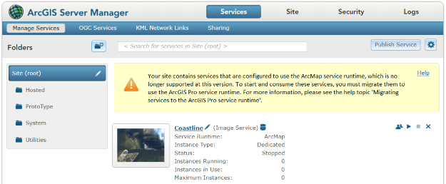
Removal of the ArcMap-based runtime
ArcGIS Enterprise 11.0 only includes the ArcGIS Pro-based runtime; this means it is the first release of ArcGIS Enterprise to no longer include the ability to publish or run ArcMap-based services.
If you upgrade to ArcGIS Enterprise 11.0 with ArcMap-based services present, compatible ArcMap-based services will be migrated to the ArcGIS Pro-based runtime during the upgrade. ArcMap-based services that can’t be automatically migrated will be stopped after an upgrade to 11.x and will require additional work. For more information on this topic, see our Removal of the ArcMap-based runtime from ArcGIS Enterprise blog.
Approve external apps for organization members
New membership management options have been added at ArcGIS Enterprise 11.0 with the new administrator ability to restrict members’ access to only approved external apps. This functionality will enhance security within your security by preventing users from accessing applications not approved for the Enterprise portal organization.
Automatically run administrative reports
To ease the duty of running administrative reports, administrators can now schedule automated reports to be generated daily, weekly, or monthly within the Enterprise portal.
Operational Health script
New in ArcGIS Enterprise 11.0 is an operational health script, operationalHealth.py. This Python script that comes installed with the Portal for ArcGIS component. This script can scan your organization for health issues that may adversely affect your ArcGIS Enterprise based on some best practices to deliver a stable, optimized, and highly functional Enterprise deployment.
Apps
ArcGIS Solutions
Starting with this release of ArcGIS Enterprise, ArcGIS Solutions now comes installed with the Portal for ArcGIS component. There is no need for a separate install, as there was with previous releases of ArcGIS Solutions in ArcGIS Enterprise.
ArcGIS Deep Learning Studio
ArcGIS Deep Learning Studio provides users with the ability extract information from imagery and share it with their organization. The app, which is part of ArcGIS Image Server, allows you to perform an end-to-end workflow that includes capturing training data, training a model, and running inferencing.
ArcGIS Server Roles
ArcGIS GeoAnalytics Server
This release of ArcGIS GeoAnalytics server includes new analysis tools and tool enhancements. The new Snap Tracks tool matches time enabled points (tracks) to nearby lines. The Snap Tracks tool can be run through ArcGIS REST API, ArcGIS Pro, and ArcGIS API for Python. For a comprehensive list of all the new features in the newest release, check out the What’s new in ArcGIS GeoAnalytics Server help topic.
ArcGIS GeoEvent Server
ArcGIS GeoEvent Server 11.0 includes significant performance improvements for users discovering and selecting features in their ArcGIS Server, ArcGIS Enterprise, and ArcGIS Online registered data stores. There is also improved performance and load times for GeoEvent Manager and data sources and services on the spatiotemporal big data store page.
Please keep in mind, when upgrading from a previous version of ArcGIS GeoEvent Server to 11.0, your configuration will not be automatically upgraded as part of this installation. You will need to manually export your configuration prior and import it after a successful completion of the GeoEvent Server 11.0 installation.
For a comprehensive list of all the new features in the release, check out the What’s new in ArcGIS GeoEvent Server help topic.
ArcGIS Image Server
This release of ArcGIS Image Server includes updates, enhancements, new tools, and improved functionality. Highlights of this release include support for new raster types and multidimensional support, and enhanced OGC support. For more on this, see the What’s new in ArcGIS Image Server help topic.
ArcGIS Knowledge
ArcGIS Knowledge 11.0 introduces a new licensing model with ArcGIS Enterprise 11.0. In this release, users will no longer need the Knowledge user type extension in order to use ArcGIS Knowledge. Licensing ArcGIS Knowledge Server will only require an ArcGIS Knowledge Server license.
Add a NoSQL data store item to the portal that references an empty Neo4j database to store knowledge graphs you create in ArcGIS Pro. When you use your own Neo4j instance, you can scale the instance as necessary to accommodate the number of databases and graphs that you require.
ArcGIS Notebook Server
In this release, ArcGIS Notebook Server now includes Esri-curated Python code snippets that can be accessed from the Notebook editor and added to your notebooks. Code snippets are pre-written code that can be called into your notebooks to perform common workflows.
ArcGIS Enterprise 11.0 also includes updates to the “Publish a notebook as a web” tool and “Overwrite web” tools. When administrators and notebook authors use the publish a notebook as a web tool, a snapshot of the notebook will be created and published as the web tool.
ArcGIS Notebook Server will also have a beta feature in ArcGIS Enterprise 11.0. ArcGIS Notebook Server supports the use of Mirantis Container Runtime (formerly Docker Engine Enterprise) and Windows container images for the ArcGIS Notebooks runtime on Windows Server 2022. This configuration will be fully supported in a future release. With this update, you will be able to use a production-ready enterprise container engine without the constraints of Docker Desktop, like the requirement of using a local directory as the ArcGIS Notebook Server workspace directory or needing the Docker install user to always be logged into the notebook server machine.
For a comprehensive list of all the new features in the release, check out the What’s new in ArcGIS Notebook Server help topic.
ArcGIS Workflow Manager
In ArcGIS Enterprise 11.0, you can now switch workflow items from any page in the Workflow Manager using the My Workflow Items button at the top of the Workflow Manager web app. The Details panel in the Workflow Manager web app has also been updated to include animates that make job updates more visible and responsive. The job list on the Work page can be sorted by clicking the name of a field in the job list. ArcGIS Workflow Manager also now has support for ArcGIS Arcadeexpressions in string fields throughout the Workflow Manager web app to allow users to dynamically populate fields with job specific information. There are additional updates to the Step templates, shared searches, shared charts, and more. For a comprehensive list of all the new features in the newest release, check out the What’s new in ArcGIS Workflow Manager help topic.
ArcGIS Enterprise on Kubernetes
The release of ArcGIS Enterprise 11.0 on Kubernetes will also bring important improvements that will support your DevOps integration and ease administration, as well as enhancing functionality supporting scalability, performance, and the resilience of your ArcGIS Enterprise environment. We also continue to move closer to functional parity with our Windows and Linux deployment options. Several of the improvements that are coming with ArcGIS Enterprise 11.0 on Kubernetes are listed below. Read even more about What’s new in ArcGIS Enterprise 11.0 on Kubernetes in this blog.
General availability to customers
When we launched the Kubernetes deployment option, an Esri Enterprise Agreement was required. With the release at 11.0 we are opening access to general availability, with no Enterprise Agreement required. The software will be licensed through an annual subscription. Please talk with your Esri representative or distributor for more details.
Disconnected environments
Some of our ArcGIS Enterprise customers require running the software in an environment disconnected from the internet. This is already possible with Windows and Linux, and we are making this a supported capability when using Kubernetes as well. You will be able to deploy, manage, and upgrade and update our software when you are configured for disconnected operations even when configured in a fully air-gapped posture or via network policies.
Horizontal pod autoscaling integration
Our customers using Kubernetes already enjoy a simple means to scale services at a granular level to optimize for dynamic or growing demand. We are enabling the Horizontal Pod Autoscaler, a capability of Kubernetes, to be configured through the ArcGIS Enterprise Manager or API. This supports highly elastic resources to be set in advance to scale out based on a pre-configured utilization threshold, up to an upper limit, and then scaled back in to consider resources after the spike in demand has subsided. It will further reduce administrative effort and monitoring and will help you maintain consistent performance of the system regardless of demand fluctuations.
Enabling data from additional data sources
Certain data storage sources were not supported when we launched ArcGIS Enterprise on Kubernetes. At 11.0, the use of Oracle and SAP HANA for data storage will be supported. Our product documentation will provide additional details.
Other important changes in ArcGIS Enterprise 11.0
Because ArcGIS Enterprise 11.0 includes many under-the-hood changes to the software, there are some important changes to be aware of.
You can anticipate the following changes in ArcGIS Enterprise 11.0:
- Removal of the ArcMap-based runtime
- Move of ArcGIS Enterprise SDK to .NET 6
- Removal of classic Esri Story Map templates
- Removal of ArcGIS Dashboards Classic
- Removal of Presentation for Map Viewer Classic
- Removal of many Configurable App templates
Take a moment to read more about these changes, as well as how to prepare for a smooth upgrade to ArcGIS Enterprise 11.0, by reading our Consider ArcGIS Enterprise 10.9.1 until you’re ready to turn it up to 11 blog.
Learn more
And those are the highlights of what’s you’ll see when you turn ArcGIS Enterprise up to 11! For a comprehensive look at everything included in this release visit the What’s new in ArcGIS Enterprise help topic and associated subtopics in the product documentation.
Ready to get started? Head over to the My Esri website for your licenses and software. Enjoy!


Article Discussion: