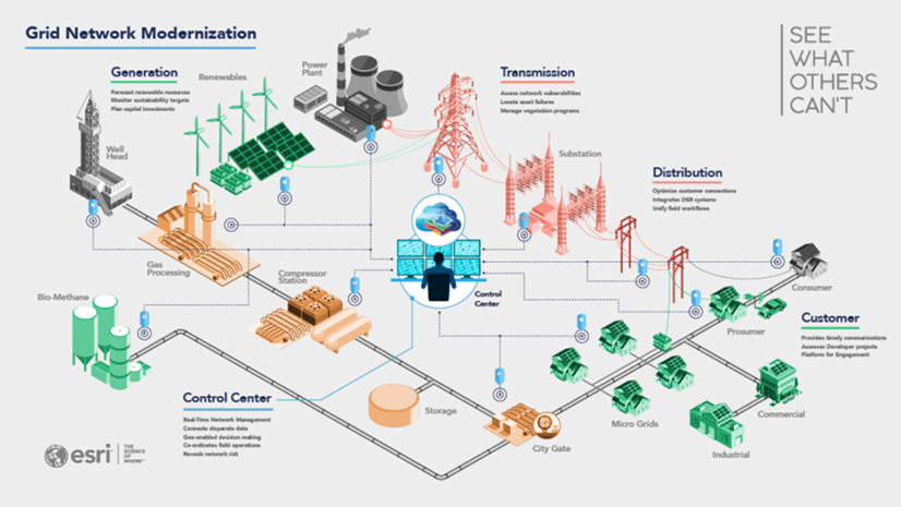
All utilities do pretty much the same thing, yet each has its own unique processes.
For example, in the US, state commissions regulate their rates; however, setting rates can be complicated as they vary from state to state and each company’s billing and customer IT systems have unique algorithms used to determine these. In addition, utilities also employ various types of worker arrangements, each with its own special provisions, which can be complicated and diverse. As a result, the payroll and work management systems become very specific. Finally, some utilities just like to do things differently.
Unfortunately, utilities find ways to model these unique processes into the design of their IT systems which results in further complications. To make matters worse, often these systems were built decades ago in computer languages no longer in use. As things change, it can be hard to figure out which workflows need to be eliminated entirely while maintaining older home-grown systems become nearly impossible. Looking forward, rules for electric vehicles and charging, smart cities, various renewable and storage facilities, and carbon pricing create even more opportunities for uniqueness.
With all of these challenges, how can utilities deal with the uniqueness of requirements while demanding no custom software? How do utilities expand services and modernize infrastructure without impacting safety, reliability, or consumer costs?
The answer is simple: modernize software to use extremely flexible products.
The Oxymoron of Customized “Off the Shelf” Products
The bottom line is that custom IT applications are a burden. So, over the years, utilities opted to replace home-grown systems with “off-the-shelf” products. The problem was, however, they had to customize these products to accommodate the unique situations. While these customized “off the shelf” solutions were better than building something from scratch, upgrades and support were labor-intensive, expensive, and risky.
The problem remained – customization.
Customization relies on developers with a deep understanding of software and architecture to write and compile code. In addition, utilities must upgrade, recompile, test, and deploy with each release.
Major IT systems have become more complicated as utilities continue to automate. Yet they are also expected to be more responsive. Utilities expect their IT systems to be able to leverage the latest capabilities. Likewise, the utilities’ customers expect them to provide modern solutions and be responsive to their needs. So as needs evolve, a utility can’t wait for the latest patch or release. Software with extensive customization may require updates that can take months or even years to plan and execute.
Configuration Plummets Risk
There is very little a software vendor can do to force utilities to standardize. This is particularly tough when many material, employment, facility contracts, regulatory agreements, rate structures, and policies stand in the way. Certainly, they can move to more industry-standard practices that can be automated. That would be the first step. However, this does not eliminate the requirements they cannot control or standardize.
Fortunately, software vendors like Esri have provided their products that utilities can use completely out of the box. Yet they still have the flexibility to create applications that meet the varying requirements of their business. How? Adopt IT systems with a wide range of configurations. This allows almost endless possibilities of how they can run the software.
How is configuration different from customization? Configuration relies on analysts with a deep understanding of business and user requirements to change how the software behaves using tools exposed by the software itself. As a result, users need not recompile or upgrade with each release. Instead, they test and deploy. As a result, the configuration allows utilities to be more responsive to requirements without significantly burdening IT.
Prototyping
We often hear a true story of a GIS analyst from a utility attending a meeting about how the company needed a new application. The attendees outlined a workflow to implement. Meanwhile, while listening, the analyst also crafted an application that met nearly all the requirements discussed during the meeting. The analyst did this by configuring ArcGIS to do what the group suggested. While this was a prototype, it helped the participants in the meeting to fine-tune the application. It ultimately led to a full-fledged production solution that varied very little from the prototype created virtually in real-time during a meeting.
Prototyping solutions through configuration takes far less time than a developer on a traditional software development project to create a design. Additionally, because the analyst who has a deeper understanding of customer workflows and requirements does the configuration, the end user is more likely to accept and appreciate the application.
Customization vs. Configuration?
The differences between the two are flexibility, lower cost and speed to implement. If a customization software project takes a long time to implement, the odds are that the requirements will change throughout software development. Software designed for configuration provides tools and “app builders” to provide small unique functionality within the overall configuration framework. These low/no-code solutions are easy and fast to deploy, and users never have to compile code. Once created, they only have to be re-tested during upgrades and new releases.
Configuration can be performed by an analyst who has taken the proper product training. It does not require a four-year degree in computer science or a similar program. As a result, utilities can access a larger talent pool to grow and support their capabilities. This also means companies can have resources closer to the subject matter in creating solutions. They can better create experiences that meet customer expectations.
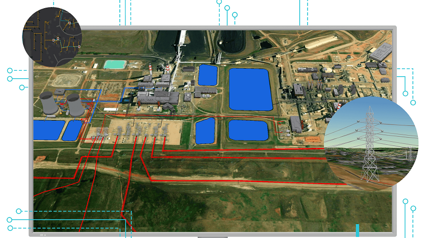
GIS – Case in Point
Esri has been serving the GIS needs of the utility market for decades. Unfortunately, no two major utility GIS implementations have been the same. To meet this reality, Esri has created an entire ecosystem of configurable applications to address these needs. This is what ArcGIS Enterprise and ArcGIS Online bring to an organization. These products provide a configurable system that allows utilities to craft a seamless GIS enterprise solution to manage and deploy content to users. These solutions allow utilities to build and maintain a GIS without resorting to risky and error-prone customization. ArcGIS has a wealth of configuration tools that allow companies to do what they need. These tools also help utilities simplify and, in some cases, eliminate outdated workflows.
Have It Both Ways
Utilities would like to adopt completely standardized processes. And it would be much simpler to implement completely out-of-the-box IT solutions. Unfortunately, the reality is that there is just too much variability in their business. However, utilities can have it both ways by implementing software rich in configuration tools, such as the ArcGIS suite of products. This move allows utilities to craft unique solutions without cracking open the innards of the core software. Configuration lets utilities have it both ways.
You can learn more at the following links:


Commenting is no longer enabled for this article