ArcGIS GeoPlanner Agenda – Esri Virtual UC 2020
Join us at the 2020 Esri User Conference! UC 2020 has many virtual sessions across hundreds of topics. Below is a focused agenda to help you navigate your way to ArcGIS GeoPlanner activities.
**Note: Please register as all-access attendee to watch sessions and participate in the virtual expo at Esri UC 2020!**
Monday, July 13 – 12:05 PM–3:50 PM PST
Tuesday, July 14 – 7:30 AM–9:40 AM and 11:10 AM–3:50 PM PST
Wednesday, July 15 – 7:30 AM–9:40 AM and 11:10 AM–3:50 PM PST
For general questions and demos regarding ArcGIS GeoPlanner visit the ArcGIS GeoPlanner Booth ID: SH-18-06 to Chat or Schedule a Meeting with a product expert. (Located in the 3D area)
For questions and demos about how ArcGIS GeoPlanner supports green infrastructure (GI) planning, visit the Conservation Booth ID: SH-15-01 to Chat or Schedule a Meeting with a GI expert. (Located in the Sustainable World area)
On-demand Sessions:
The following sessions are available for interested attendees to watch on their own time.
Session ID: 11182
ArcGIS GeoPlanner: Getting Started

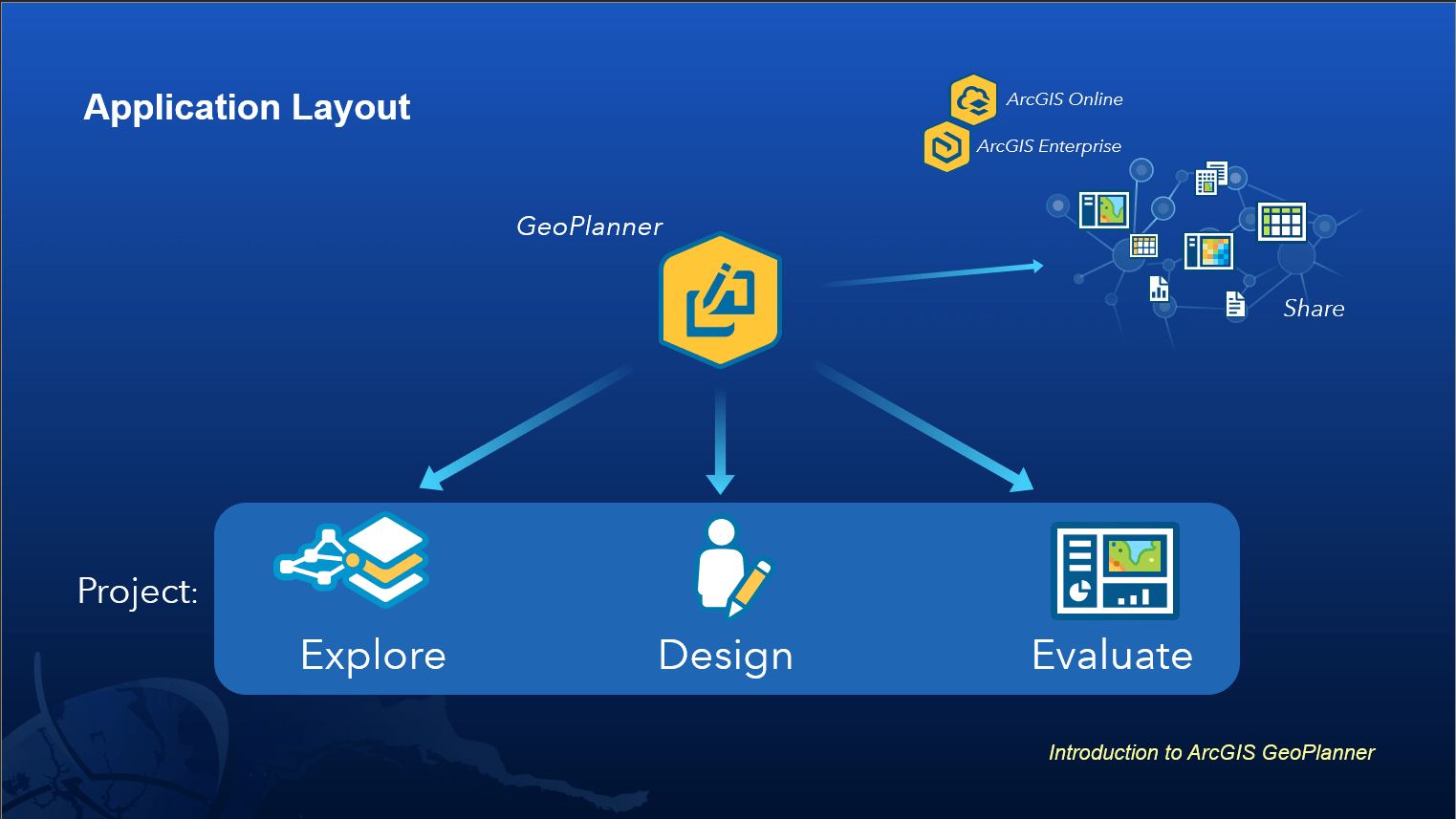
ArcGIS GeoPlanner is a premium web application for iterative multiscale planning. GeoPlanner comes equipped with project templates, rich libraries of environmental and other data, and analytical capabilities for kickstarting your work. Join us and learn how to use GeoPlanner to create, analyze, and report on planning alternatives. We will highlight many capabilities, including modeling and analysis, sketching, key performance indicators, and scenario management to improve decision making and facilitate more robust and collaboratively driven planning.
Session ID: 11999
ArcGIS GeoPlanner: Advanced Analysis

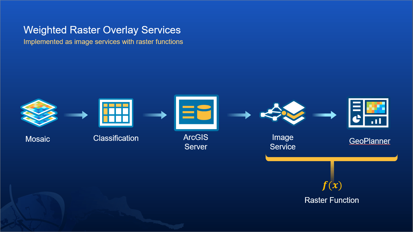
This session covers how you can configure suitability models, also known as weighted raster overlays, within ArcGIS GeoPlanner and other select advanced capabilities of the application. The suitability models covered represent a robust analytical tool used to help better understand your environment, explore relationships amongst your data, and provide a clearer understanding of favorable locations for activities. The session will explore how advanced configurations help foster collaboration, enhance transparency, and provide greater access to stakeholders at large given their ease of use and accessibility via the web.
Session ID: 10900
Green Infrastructure Planning with the Living Atlas and ArcGIS GeoPlanner

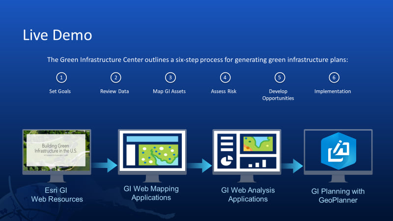
Esri’s Green Infrastructure (GI) initiative is a collection of freely available authoritative geospatial resources, newly generated data, online applications, and downloadable models with the aim of empowering citizens, organizations, and governments to engage in GI work, all while initiating a national vision for GI planning. Join us in exploring this content, including data updates derived from the latest land cover release, that help to identify your regions most valuable natural assets, how they are changing, and where they are being lost. Learn how to access this vast ecosystem of online resources via the Living Atlas and see GI planning in action with ArcGIS GeoPlanner, a premium application for geodesign and scenario-based planning.
Related UC Special Interest Group (SIG) Virtual Meetings (Streaming Live):
Thursday, July 16
6:45 AM PST: Conservation SIG
6:45 AM PST: Environment & Natural Resources SIG
6:45 AM PST: Non-Profit and Sustainable Development SIG
10:30 AM PST: Forestry SIG
3:30 PM PST: Renewables SIG
ArcGIS GeoPlanner Resources:
- Product page
- Geonet
- Training
- Contact the team anytime at geoplanner@esri.com
See you at UC 2020!


Article Discussion: