Every year around this time we get excited to connect with our users at the Esri User Conference. The Open Platform team can’t wait to see you July 13-17, 2026, in San Diego, California.
The Open Platform team
ArcGIS is an open, interoperable system that drives efficiency and innovation. Sharing, collaboration, and interoperability are crucial to addressing today’s challenges with urgency.
At Esri, the Open Platform team is dedicated to an open and secure design architecture that allows users to seamlessly integrate within their specific environments.
Our open vision enables users worldwide to effectively work with geospatial data, empowering organizations of every industry with location intelligence.
Whether you are attending in-person or virtually, this quick-reference guide will help you find all the Open Platform focused sessions and activities at UC so you can make the most out of your time at the event.

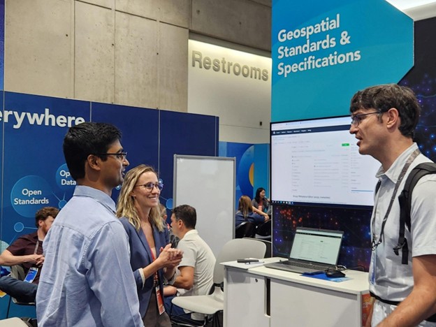
The Open Platform area within the Esri Showcase at the Expo will include four kiosks:
- GIS Data Formats & Specifications
- GIS Metadata, Catalogs & Search
- Data Interoperability & ETL Patterns
- OGC Web Services
Come find us!
The Open Platform team will be in the Expo area. We are excited to hear and discuss workflows, best practices, and receive any feedback and/or questions you may have. Please come talk to us about your work at any point during the available Expo hours.
Expo Hours
- Tuesday, July 14, 9:00 am–5:30 pm PT
- Wednesday, July 15, 9:00 am–5:30 pm PT
- Thursday, July 16, 9:00 am–4:00 pm PT
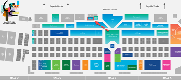

Explore the 2026 Esri UC Events Map via web and mobile (iOS or Android) to locate us at the Esri Showcase within the Expo area and to navigate to our booth and sessions. You can also consult on-site interactive kiosks in the Expo area to get directions at the event venue.
There will be many sessions and activities discussing Esri’s Open Platform at UC this year. To see a list of all related sessions and activities, take a look at the Open Platform Custom Agenda.
GIS Data Formats & Specifications
Esri has been an active participant in the development of many geospatial standards. We have been active in the Open Geospatial Consortium (OGC), ISO TC-211, IHO, FGDC and many other standards bodies, and standards have proven to be a highly effective mechanism for achieving interoperability.
While the world of IT and geospatial standards is vast, feel free to bring your questions, ideas, and feedback on this valuable topic to us at the GIS Data Formats & Specifications kiosk at the Open Platform showcase.
Whether you are interested in knowing more about the traditional standards for data, metadata and web services or are interested in newer community standards or the emerging areas of cloud native standards; we are here to help.
Talk to us about…
- Standards related to Simple features, Coordinate reference systems and other foundational GIS standards
- Different standards bodies – OGC, ISO, IHO etc. and Esri’s active involvement in the development of standards
- Emerging Cloud Native standards
- New OGC APIs – RESTful and JSON based
- New community Standards and Esri’s support for I3S and 3D Tiles
- Open-Source GIS
- Supporting open initiatives – Open Science and Open Data
- Types of interoperability – Foundational, Structural, Semantic, and Organizational
Resources
- OGC Web Services-ArcGIS
- OGC API Features-ArcGIS
- OGC Geopackage-ArcGIS
- OGC Compliancy certificates
- New Options for Decentralized Collaboration That Protects Data Sovereignty
- What’s new for ArcGIS Maritime in ArcGIS Pro 3.3
- Introduction to the SpatioTemporal Asset Catalog (STAC)—ArcGIS Pro
 Click this GIS Data Formats and Specifications link to find your way to the Geospatial Standards and Specifications focused sessions.
GIS Metadata, Catalogs & Search
Metadata helps connect everything we do across the ArcGIS! It powers how data and content is organized, discovered, understood, and reused. Metadata drives how data is surfaced through search, how it’s presented and organized in catalogs, and ultimately how effectively it can be used by others. In a world of growing data volumes and AI-driven workflows, metadata, catalogs, and search are more interconnected than ever.
At the kiosk, we’re excited to talk with you about how these capabilities come together to create a more unified and powerful discovery experience across ArcGIS.
Talk to us about…
- What metadata is in ArcGIS and how it supports search and catalog experiences
- The metadata editor, metadata management, and how metadata flows across ArcGIS and beyond
- The new Dublin Core+ metadata style and simplified approaches to authoring metadata
- Metadata and catalog standards such as FGDC CSDGM, ISO, INSPIRE, and DCAT
- Essential metadata elements that improve search, discovery, reuse, and AI readiness
- The Item Details assistant (beta) and how AI can help generate and enhance metadata
- ArcGIS Hub assistant (beta) search agent to help search, understand, and explore data in Hub sites through natural language
Resources
- Metadata Year in Review for 2025
- Dublin Core+ Now Available in ArcGIS Pro 3.7
- Early Adopter Community for the Item Details assistant
- Early Adopter Community for the ArcGIS Hub assistant (beta) search agent
- Metadata, Catalogs, Search Esri Community
- Metadata Essentials for AI-Ready GIS
- GIS 101: Metadata Then and Now
Cannot swing by the kiosk? Take our Metadata Impact and Priorities Survey to help us gather insights on metadata significance and priorities for your organization!
Click this GIS Metadata, Catalogs, and Search link to find your way to the GIS Metadata, Catalogs, & Search focused sessions.
Data Interoperability & ETL Patterns
Many tools ingest different data types into the ArcGIS system, and there are also many ways to transform that data while it is loading. Visit this kiosk to discuss overall principles and specific examples using the ArcGIS Data Interoperability extension, the new ArcGIS Data Pipelines app, and Python notebooks (in both ArcGIS Pro and ArcGIS Online) for those who are comfortable with coding options.
Talk to us about..
- Local Well-Known files. For example using ModelBuilder to convert CSV files to features with complete schema control.
- Cloud Well-Known files. For example, extraction of features from GeoParquet files stored in an S3 object store, without downloading the data.
- Complex data models For example, converting GeoJSON with array properties into a base feature class with related tables.
- APIs that require pagination and parsing. For example, retrieving a large dataset from an Open Data site in multiple parts.
- APIs that are secured. For example, using API keys or tokens to access datasets without coding.
- Cloud warehouses. For example, reading Snowflake by using a SQL statement to preprocess data before retrieval.
- On-premises databases. For example, an OLE DB connection to a user ODBC data source in ArcGIS Pro.
- Well-known services. For example, accessing a WFS server as both GML and GeoJSON in Pro and Data Pipelines apps.
Resources
- ETL Patterns & Data Interoperability Esri Community
- ArcGIS Data Interoperability extension
- ArcGIS Data Interoperability server extension
Click this Data Interoperability and ETL Patterns link to find your way to the Data Interoperability and ETL focused sessions.
OGC Web Services
GIS reaches its full potential when data, tools, and methods work together as a connected system of systems. Open standards help make the connection possible. Standards make it easier to share, discover, and reuse geospatial data globally. Esri is a longstanding champion of open standards and a principle, active member of the OGC. ArcGIS supports a wide range of OGC Standards including OGC-API Features, OGC-API Tiles, WMS, WFS, WMTS, WCS, and WPS.
Talk to us about..
- Open standards for geospatial data, services, and newer modular APIs.
- The OGC standard development process, testing certification, and ways to participate.
- Interoperability of geographic data.
- Swagger and Open API interfaces to API-Features.
- Publishing and consuming OGC services and APIs.
- 3rd party support – Qgis and Geoserver.
Resources
OGC Related
- OGC Standards | WMS, WFS, GeoPackage & 80+ Open Geospatial Specs
- OGC API
- Open Geospatial Consortium (Github)
- Roadmap · Standards Roadmap
- OGC-tracker/OGC-Standards-Tracker
ESRI related
- OGC | ArcGIS Enterprise on Windows and Linux documentation
- OGC support in ArcGIS Enterprise | ArcGIS Enterprise on Windows and Linux documentation
- OGC—ArcGIS Online Help | Documentation
- Publish hosted OGC layers—ArcGIS Online Help | Documentation
- Use an OGC API service | ArcGIS Pro documentation
- OGCFeatureLayer | References | ArcGIS Maps SDK for JavaScript
- Browse OGC API feature service | ArcGIS Maps SDK for .NET | Esri Developer
- Display OGC API collection | ArcGIS Maps SDK for .NET | Esri Developer
- Query with CQL filters | ArcGIS Maps SDK for .NET | Esri Developer
- Publishing and Consuming OGC Services | ArcGIS API for Python | Esri Developer
Click this OGC Web Services link to find your way to the OGC Web Services focused sessions.
Also, check out the Geospatial Ecosystems & SDI kiosk at the Mapping & Statistics Showcase.
Climate, disasters, people, nature, and more cross borders; our data and technology must cross borders, too. Spatial Data Infrastructures (SDI) are evolving to address common goals and shared challenges, audiences are expanding, and complex geospatial ecosystems are emerging. Join us to engage with experts and explore advancements in integrated geospatial infrastructure that support your multi-organizational initiatives. Learn about community implementation patterns, capabilities, best practices, tools, and resources to help you meet modern demands.
Talk to us about
- Evolving Spatial Data Infrastructures (SDIs)
- Emerging ecosystems
- Pillars of modern SDI
- Strategies to maximize your impact
- Best practices for successful implementation
- Implementation resource
Resources
Click this Geospatial Ecosystems & SDI Custom Agenda link to find your way to the Geospatial Ecosystems & SDI focused sessions.
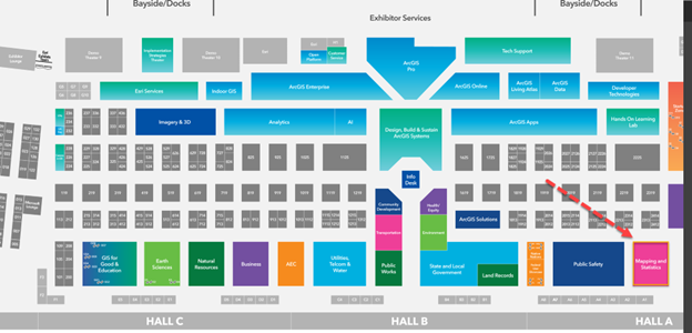
And check out these two Special Interest Group (SIG) meetings:
Wednesday, July 15, 11:30 am -12:30 pm Geospatial Data Ecosystems and SDI SIG
Thursday July 16, 11:30 am -12:30 pm Community Engagement SIG
See you soon in sunny San Diego!



Article Discussion: