
Emergencies can happen anywhere, any time. In an emergency, every second counts. To improve emergency response at K-12 schools, U.S. states are passing legislations and providing funding for the creation of accurate digital floor plans for schools to share with first responders.
Esri’s indoor geographic information system (GIS) capabilities enable the creation, maintenance, sharing, and use of digital indoor maps that can enable faster emergency response and ensure compliance with state mandates.
Indoor Maps for K-12 School Emergency Response
Unfortunately, security threats at schools are a reality and can range from overcrowding, hostile caregivers, gas leaks, and natural disasters, to lockdown events. No matter the cause, it is critical to keep students safe where they show up every day to learn and grow. Therefore, it is important to respond to emergencies as efficiently as possible to limit the consequences as much as possible.
During a school incident, telecommunicators, first responders, and school safety personnel need quick and easy access to facility and building layouts to support their operations. They often rely on floor plans to orient themselves within the campus and to navigate buildings to locate individuals, facilitate evacuations, and address fires or other incidents.
However, according to school safety experts and law enforcement, these maps are often out of date and therefore unreliable. Consequently, telecommunicators, first responders, and school safety personnel may not have quick and ready access to shared information that enables interoperable communication and coordination when arriving on site. Lack of situational and location awareness can cause delays in response times. Safety binders that are often in use take too long to filter through to get the relevant information that would allow them to capture the situation and building layout. In addition, not all emergency response professionals have access to indoor maps, with access often limited to fire, Emergency Medical Services (EMS), or law enforcement. Telecommunicators may not have access at all. Furthermore, indoor maps are frequently not integrated into the software systems that these professionals use daily, such as computer-aided dispatch (CAD) systems. This lack of integration and access can leave emergency response personnel without critical information, thereby potentially impeding response activities, especially if one or more agencies are called upon to provide mutual aid.
Multiple US states are now passing legislations for K-12 schools to update and digitalize their campus maps and share them with local first responders such as school resource officers (SROs), law enforcement, and fire/EMS. Esri, leading provider of GIS technology, can help schools meet this requirement. Most state and local governments use GIS in many ways and Esri products are commonly used in the public safety sector, so your local law enforcement and first responders may already be familiar with the ArcGIS suite of products as well as public safety software that use ArcGIS, such as CAD systems built by Esri business partners.
Intuitive Map Creation and Maintenance
With ArcGIS Indoors, schools can transform their existing CAD or BIM facilities floor plans into interactive digital 2D or 3D maps. If there is no pre-existing floor plan, the map can be easily created and updated using an intuitive web application called Floor Plan Editor. As this app doesn’t require sophisticated CAD/BIM or GIS skills, school administrators or other staff can effortlessly maintain the map on their own.
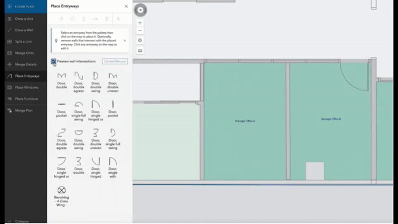
In case the school decides to modify their building layout or repurpose some of the indoor space, such as turning a bigger classroom into two separate ones, it can be easily accounted for on the digital map by drawing up a new wall and renaming the spaces. That way, the map is up to date.
This is particularly crucial given that, in many cases, K-12 floor plans are typically updated only a few times a year even though aspects of a school may change more often. Floor Plan Editor empowers those most familiar with the facility to maintain up-to-date maps by allowing real-time modifications. This ensures that telecommunicators and first responders have access to accurate information, thereby eliminating confusion that could arise from using outdated maps, which may no longer reflect the current layout of the building.
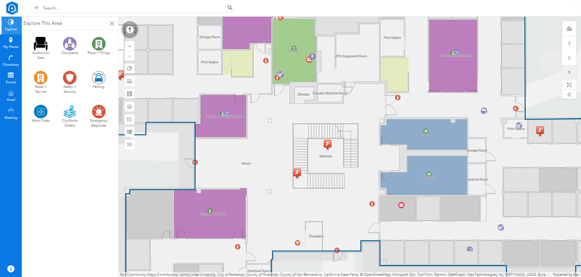
Providing a Common Operating Picture
Effective communication and information sharing are crucial for all stakeholders during an emergency. Indoor maps created with ArcGIS Indoors can provide schools and emergency responders with an immediate and up-to-date overview of the building layout as well as locations of:
- Site and roof access points, as well as building entrances and exits
- Rooms, stairwells, and amenities
- Hazardous areas, such as laboratories and their contents including hazardous chemicals
- Occupants (staff and students)
- Lifesaving equipment, such as first aid kits, fire extinguishers and Automated External Defibrillators (AEDs)
- Infrastructure systems, such as security cameras
- Other points of interest
ArcGIS Indoors also offers tools to visualize indoor maps in both 2D and 3D formats. Additionally, 360-degree photos of the indoor spaces can be included to provide first responders with a realistic visualization so that they can arrive on-scene prepared with as much information as possible. The map is accessible through desktop, web, mobile applications, and CAD and mobile mapping systems built by Esri partners, and can be easily shared among school staff, telecommunicators, and first responders. During an emergency, school staff can review the map on their mobile phones to locate important points of interest like AEDs, and Stop the Bleed and first aid kits. Moreover, the map helps quickly identify optimal routes to specific points inside the building, facilitating efficient navigation to arrive on scene as quickly as possible, and for other situations, such as evacuating occupants.
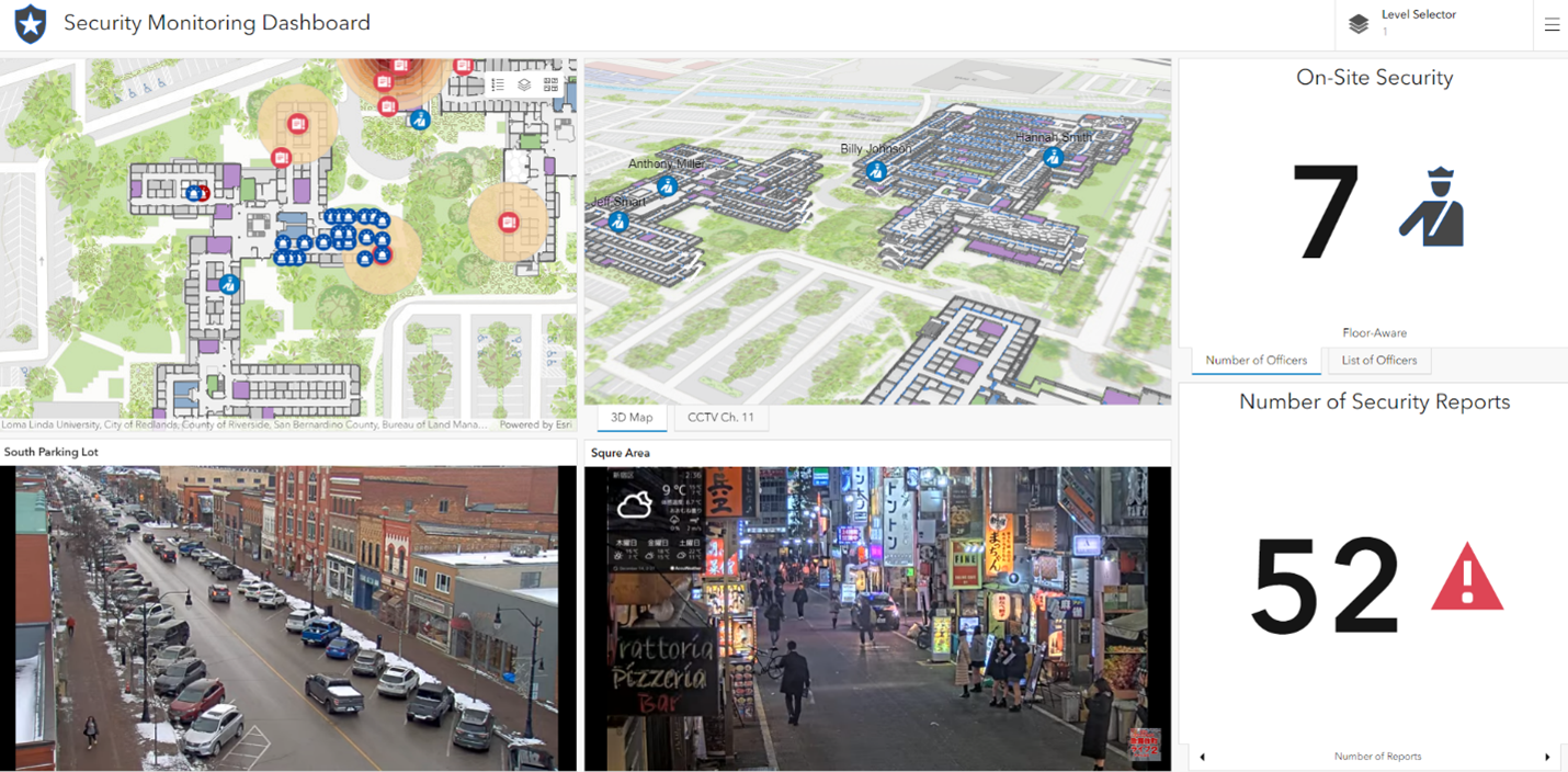
Schools frequently install security cameras both inside and outside their buildings, which can be effectively utilized during emergencies. The live footage from these CCTV cameras can be integrated into a comprehensive security monitoring dashboard, enabling simultaneous visualization of multiple perspectives, including 2D and 3D maps, video feeds, and the live locations of school personnel. This critical information can be shared with all relevant parties involved in the emergency response, including telecommunicators and first responders from the jurisdiction, as well as other agencies that may be called upon for mutual aid.
Live Location Sharing
Using ArcGIS IPS for indoor positioning within ArcGIS Field Maps, staff can efficiently share their live locations with emergency responders. This real-time insight of number and locations of staff within the building provides responders with critical information needed for a more effective response coordination.
Taking Action Before Emergencies Happen…
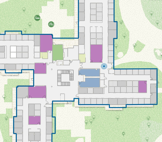
There are broader applications of indoor maps generated using ArcGIS Indoors beyond emergency response scenarios. These maps offer significant advantages over traditional printed or PDF maps, which are static and lack the dynamic capabilities necessary for comprehensive security management.
One key area where these indoor maps can add value is in the proactive analysis of potential threats and vulnerabilities within school facilities before incidents can happen. For instance, these maps can be used to identify CCTV camera blind spots, ensuring that all critical areas are under surveillance. This could potentially enhance overall security and help in the strategic placement of additional cameras or security personnel.
Moreover, indoor maps can play a crucial role in day-to-day security operations. By integrating facility telemetry, security personnel can monitor the status of doors and windows in real-time, ensuring that all access points are secure. For example, during the school day, security staff can use these maps to quickly verify if doors are locked or unlocked and take immediate action if necessary.
At the end of the school day, an indoor map integrated into a site security checklist mobile application can be invaluable. Staff members can physically check each door, mark it as locked, and ensure that all access points are secure before leaving the building. This process not only enhances the security of the facility but also provides a systematic and efficient way to manage daily security tasks.
Conclusion
An interactive indoor map generated with ArcGIS Indoors and kept up-to-date using Floor Plan Editor gives everyone involved in responding to an emergency the freshest data possible. Together with indoor positioning enabled through ArcGIS IPS, they can enhance security protocols and serve as a common operating picture for stakeholders, leading to increased situational awareness, enhanced coordination, and reduced response times. By providing a comprehensive and real-time view of the school building, you can significantly improve safety and security, ensuring that K-12 students and staff are better protected in an emergency.
Watch this video to learn how indoor maps can be easily created and updated with Indoors. Explore Indoor GIS resources and contact your Esri account representative to learn more about indoor mapping for schools.


Such an insightful piece! The emphasis on accurate and up-to-date indoor mapping for K-12 schools highlights how technology can truly save lives. The integration of ArcGIS Indoors with emergency response systems not only improves coordination but also ensures that first responders have the clarity they need in critical moments. Investing in these tools is investing in the safety of our children.