ArcGIS Living Atlas of the World provides foundation elevation layers and tools to support analysis and visualization across the ArcGIS platform. These layers get updated quarterly with high resolution elevation data from open sources and community maps program. In this release, world elevation layers are updated with a few high-resolution elevation datasets as below.
Terrain and TopoBathy layers are updated with:
- Lidar derived 0.5-meter DTM’s covering entire Upper Austria state, Austria
- Photogrammetrically derived 1-meter DTM covering entire Madrid city, Spain
- Updates to USGS 3DEP 1-meter DTM’s covering partial areas of the conterminous United States
- Updates to Vienna City 1m DTM’s with 2018 lidar survey
TopoBathy layer is updated with:
- Updates to NCEI 1/9 arc sec (~ 3 meters) DTM’s covering North Carolina, Puerto Rico and U.S Virgin Islands coast
In this release, approximately 346,000 square kilometers of new coverage of USGS 3DEP 1 meter has been added. The graphic below shows the new addition (magenta) along with previously available coverage (green).

Here are a few examples highlighting the improvements with before and after images.
Linz, Austria – depicting the fine details in urban landscape with lidar derived 0.5 meter data in comparison to Austrian 10 meters

Two Point Mountain, Idaho – highest peak of 3086 m (10124 feet) in the Boise Mountain depicted with USGS 3DEP lidar derived 1 meter in comparison to NED 10 meters

Puerto Rico – depicting the fine coastal details with 1/9 arc sec (~ 3 meters) bathy data in comparison to 90 meters coastal relief model

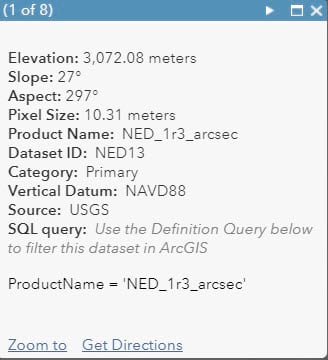
Terrain and TopoBathy layers have pre-defined pop-ups, which are enhanced to include many key metadata fields to help understand the datasets better. Default pop-up now also includes a SQL query syntax, which you can use (copy/paste) for definition query in the ArcGIS Desktop applications (Pro, ArcMap) to filter a dataset to work with.
These data updates will be rolled out to the other world elevation tiled layers – Terrain3D, TopoBathy3D, World Hillshade and World Hillshade (Dark) in the next quarter.
For more information about the various data sources available in World Elevation services, check out the Elevation coverage map. You can help improving these services by contributing high-resolution elevation data to Living Atlas of the World. To participate and learn more, check out the Esri Community Maps for Elevation program.

Commenting is not enabled for this article.