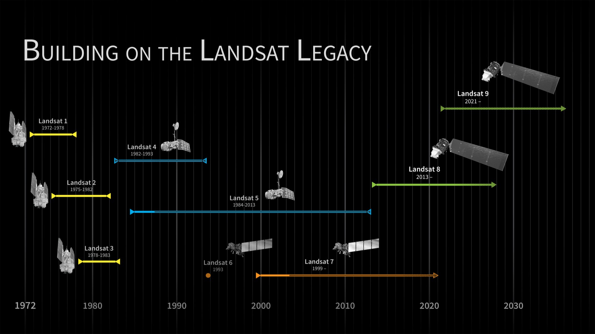
Landsat 9 launched on September 27, 2021, from Vandenberg Space Force Base in California. The USGS opened the imagery to the public on February 10, 2022. Five days later, on February 15, 2022, Landsat 9 imagery began to make it’s way into ArcGIS Living Atlas of the World.
In an era when receipt of images and data from low-Earth-orbiting satellites is more or less “routine”, it’s hard to remember that a few short decades ago this was not the case. As the first land-observing satellite program, Landsat laid the foundation for modern space-based Earth observation. Today, Landsat offers the longest near-continuous data record of Earth’s land surface as observed from space.

Then and Now
The Landsat program began collecting multispectral imagery of the Earth in 1972. Landsat 1 was launched with two sensors onboard, one of which was the Multispectral Scanner System (MSS). MSS came to the mission through an unsolicited proposal from aerospace engineer Virginia Norwood. While considered experimental, and deemed the secondary sensor onboard, it turned out to be the “workhorse” and revolutionized the Landsat program and the future of multispectral earth observation and mapping.
Well-known USGS cartographer, Alden Colvocoresses, had been highly cynical about the MSS’s ability to collect cartographically accurate data with “a little mirror in space,” but upon seeing the first MSS image he turned to his colleagues and exclaimed “Gentlemen, that’s a map.” He later wrote to Norwood and told her “it has become obvious to me and others, that the MSS is a real mapping instrument.”
Over the years, the Landsat program has relied on a diversity of scientists to provide insight and make recommendations on the spectral bands that are most useful for answering questions in their respective fields. This has been integral to the program’s evolution in Earth observation. In February 2013, Landsat 8 was launched with two new sensors onboard, the Operational Land Imager (OLI) and the Thermal InfraRed Sensor (TIRS). These sensors represented yet another revolutionary advancement in spaceborne remote sensing technology.
In order to condense build time and mitigate the risk of a gap in observations, Landsat 9 largely replicates its predecessor Landsat 8 in terms of spectral, spatial, radiometric, and geometric qualities of the imagery collected. They both carry the same sensors, OLI and TIRS, and collect the same eleven spectral bands. This overlap between missions also presents significant advantages when considering both collection capacity and data continuity. Landsat 9 has been placed in an orbit that is 8-days out of phase with Landsat 8. Using the satellites in tandem, collection capacity is doubled and global coverage can now be achieved every 8-days, instead of every 16-days.
While Landsat 8 and 9 are identical in many regards, there are some notable improvements with Landsat 9. One such improvement is the depth of the spectral data. Though they share the same spectral bands, Landsat 8 provides 12-bits of data per band while Landsat 9 provides 14-bits. In practice, this provides the ability to detect and depict additional details in very dark and very bright areas of the Earth’s surface, from densely forested areas to snow fields.

Landsat in Living Atlas
The latest available Landsat 8 and Landsat 9 scenes are added to Living Atlas on a daily basis. No new imagery layers were required to bring Landsat 9 to Living Atlas. Since the mission and data are nearly identical to Landsat 8, and thanks to the flexible design of our Landsat pipelines, it didn’t take long for our product engineers to begin piping the new imagery into our existing Landsat Level-1 and Level-2 dynamic imagery layers.
NOTE: If distinguishing between Landsat 8 or Landsat 9 imagery is required, users can isolate each by filtering with the ‘dataset_id’ field.
Living Atlas Landsat Layers:
Additional Living Atlas Landsat Layers
Special thanks and shout out to Vijay Pawar and Abhijit Doshi for all of their incredible work and tireless efforts to bring all of this amazing imagery to Esri users. We couldn’t do it without you!
And of course to everyone at NASA and the USGS who make this all possible!
Quotations in this post are from Laura Rocchio’s 2011 article “Chronicling the Landsat Legacy,” The Earth Observer [pdf]


Commenting is not enabled for this article.