OpenStreetMap (OSM) is an open, editable map of the world. For several years, Esri has provided access to OSM data as a basemap. This started with Esri referencing raster tiles hosted by OpenStreetMap and has evolved to Esri generating and hosting vector tiles, which are updated every 3 weeks with the latest OSM data at the time. These basemaps are ideal for high-performance visualization but have limited capabilities beyond that.
New Feature Layers
This year, Esri is introducing a new set of feature layers that provide access to OSM data. These feature layers will be hosted in ArcGIS Online and configured to scale. Because the data is published as feature layers, they will support visualization and analysis, including the planned ability to extract selected areas of the data (e.g. a city or neighborhood) for offline use or publishing in your own portal. As with OpenStreetMap itself, the data is published under an open (ODbL) license.
One of the biggest benefits of these new feature layers is that they will be updated continuously with the latest edits to OpenStreetMap. Esri will host a replica of the OSM data in a dedicated ArcGIS Online organization, and update that replica with minutely changes (diffs) to OpenStreetMap. Edits made directly to the OSM data will typically appear in the ArcGIS Online feature layers within a few minutes!
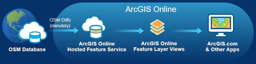
In order to support timely updates of the data, Esri will be hosting the OSM data as separate regions (e.g. North America, Africa, Europe, etc.), as they are made available on the Geofabrik downloads site. An initial set of layers for all regions worldwide are available now! The OSM data is published as separate feature layers of different types (e.g. buildings, highways, waterways, amenities, shops, etc.) based on their OSM tags. As features are added or updated in the OSM data using one or more of these tags, they will quickly appear in the feature layers.
Sample of OpenStreetMap Feature Layers
This map features the buildings, highways, and amenities layers for downtown Los Angeles, displayed on the OpenStreetMap Vector Basemap in Light Gray Canvas style. You can navigate the map and click on features for more details based on available OSM tags.
Access the Layers
You can browse these feature layers now by visiting the OpenStreetMap site in ArcGIS Online, which includes a gallery of maps and layers featuring the OSM data hosted by Esri. You can also access these layers in the OpenStreetMap Layers (Beta) group. If you find a layer in this group that is of interest to you, you can sign in to ArcGIS Online and add to favorites so it’s easily accessible for later use. As new layers are added for North America and other regions over the coming weeks and months, they will be added to the group.
OpenStreetMap License and Contributors
OpenStreetMap data is provided under an Open Database License (ODbL). As a live replica of the OSM data, the ArcGIS Online feature layers are also licensed under ODbL. This means that you can use the data freely in your work, with proper attribution to OpenStreetMap contributors, under the terms of the ODbL license. If you include one of the maps or layers in a web map or app that you create, it is important that you also include Credits (Attribution) to OpenStreetMap (i.e. “© OpenStreetMap contributors”) in your item.
What’s Next
The OpenStreetMap feature layers are now in beta release. We will stay in beta for a few months while we update and publish additional feature layers of the OSM data to ArcGIS Online based on user feedback. The feature layers currently support visualization and analysis using ArcGIS Online analysis tools. We intend to support extract of local areas of data for these layers, but have not yet enabled that capability.
Update: Several new feature layers for Africa, Asia, Australia and Oceania, Central America, Europe, and South America have now been published and are available in the OpenStreetMap Layers (Beta) group. You can use the group categories to filter the content to just see layers for these existing region and soon other regions.
During the beta period, we invite you to explore the layers and test in your maps and apps. If you want to create a more focused layer (e.g. schools or hospitals), you can copy a layer in the ArcGIS Online map viewer and create a filtered view. We will publish additional blog articles that demonstrate various ways in which the OSM feature layers can be used.
If you would like to contribute to OpenStreetMap and see your data reflected in these layers, we encourage you to sign up and join the OpenStreetMap community. Many ArcGIS users are making their useful and authoritative data available to others through OpenStreetMap, or just mapping for the fun of it in their free time. Happy mapping!

This is great!
Quick question: I’ve noticed a few minor bugs (mainly highway shields) as I’ve been using the data in different styles. Is there anyone I can send those to?
Thanks, Andrew. If the bugs are related to specific OSM feature layers (e.g. OpenStreetMap Highways (North America)), you can add a comment on that layer item. If it’s more general, you can send an email to osm@esri.com with the details (e.g. name of the layer(s) with issue and perhaps a couple screenshots).