Springtime isn’t all warmer days, pretty flowers, and Peeps. It’s also the season for allergies, floods, and tornadoes. As the South and Midwest U.S. have coped with a series of deadly tornado outbreaks in the last few weeks, it’s natural to reflect on other serious outbreaks from the past.
Recently, I’ve seen a few maps of the infamous 1974 Super Outbreak. After 49 years, it is still one of the most active and deadliest in history. Many of these outbreaks can be mapped using the Tornadoes and Tornado Tracks layers in Living Atlas, coming from official data from NOAA’s Storm Prediction Center.
Let’s begin…

Create a Tornado Outbreak Map
Step 1 — Sign in to your ArcGIS account and open Map Viewer. Then add layers to the map.

Step 2 — Choose Living Atlas from the Add layer drop-down.

Step 3 — Enter “tornado” in search to locate matching layers from Living Atlas. Scroll down to locate the Tornadoes layer and click (+) to add it to the map. Repeat for the Tornado Tracks layer.

Step 4 — Change the basemap. I went with the Newspaper Map theme. Depending on how your ArcGIS Online Organization is setup, you may have different basemap options. You can still add Newspaper Map to your map from Living Atlas, as in Step 3, and select “Use as basemap” in the layer settings.

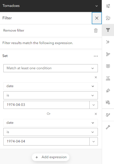
Step 5 — Click Filter in the Settings (light) toolbar on the right. Click Add expression. In the image below you’ll see that I choose the Date field an specified the two days of the outbreak, April 3rd and 4th. Click Save. Be sure to select “Match at least one condition” so the filter uses an “or” function rather than an “and”. Apply this filter to both the Tornadoes and Tornado Tracks layers.
Step 6 — Click Effects in Settings toolbar (below Filter) and choose a Drop Shadow. Adjust the settings on the drop shadow (click the six dots to the left of the description). Click Save and your map is ready to share!

The final map.
For mapping real-time tornado events, check out the Storm Reports layer in Living Atlas. An update to the archived tornado layers used in this map will be coming soon with data through 2021.

Article Discussion: