Like many of you, I hear about artificial intelligence (AI) almost every day. The conversation ranges from how AI is already showing up in our daily lives to how it can help us work more efficiently, make better decisions, and rethink what is possible in our professional roles.
When I started thinking about AI and what it means to me as a professional, I realized I had more questions than answers. Some of the concepts sounded familiar, but I wanted to better understand what they really meant and how they applied to the work we do every day. If you have had a similar conversation with yourself, you know it can quickly turn into a wide-ranging exercise in reading, watching, listening, and sorting through a lot of information. After spending time in that research, I decided to focus on a few key questions:
- How did artificial intelligence evolve into what it is today?
- How is Esri applying artificial intelligence across ArcGIS?
- What could AI and geographic information system (GIS) technology mean for the water industry?
Understanding the Basics of Artificial Intelligence
Artificial intelligence has a long and interesting history. It is often traced back to the 1950s, when great thinkers like Alan Turing began asking whether machines could think. At the 1956 Dartmouth Summer Research Project on Artificial Intelligence, researchers formally explored how computers might mimic human intelligence. Early progress included systems that could solve puzzles and process language, but technology limitations eventually slowed momentum and led to a period known as an “AI winter.”
Interest returned in the 1980s with expert systems, which captured human knowledge in computers through if-then logic. These systems helped bring AI into the commercial market by supporting decision-making in specific fields. However, they were difficult to maintain because the knowledge had to be gathered from experts and entered manually. That process was time-consuming and expensive; combined with unmet expectations and the rise of desktop computing, it contributed to another AI winter.
The next wave of progress came in the late 1990s and the 2000s, supported by the growth of the internet, improved computing power, and access to much larger volumes of data. Machine learning shifted the focus from manually defined rules to statistical approaches that could identify patterns in data. In the 2010s, advances in neural networks and deep learning accelerated that progress and brought AI into much broader public awareness.
Today, advanced processors, high-bandwidth memory, cloud services, and increasingly connected datasets continue to move AI forward. AI is now woven into many parts of our daily lives, and it is changing how we understand, analyze, and interact with the world around us.
Esri’s Approach to AI
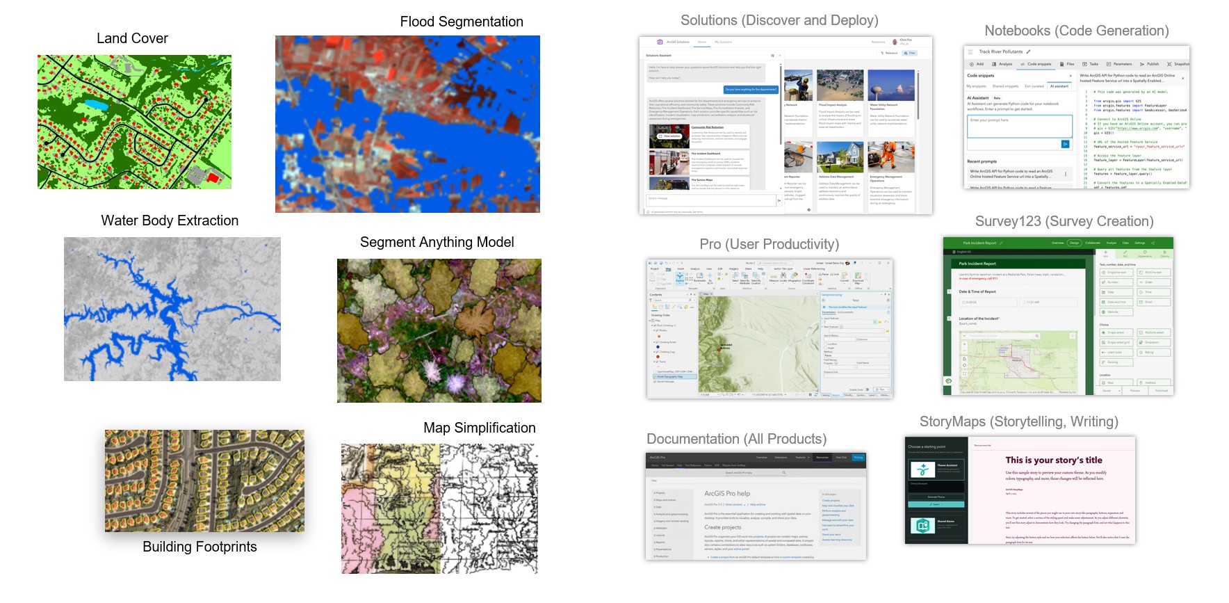
Esri’s work with artificial intelligence is grounded in a practical goal: to help users get more value from their spatial data. Over time, this work has evolved from automation and pattern recognition to advanced machine learning, deep learning, and spatial AI capabilities across ArcGIS. These tools help users analyze imagery, detect change, extract features, model patterns, and turn complex data into insight at scale.
Within ArcGIS, AI supports several important capabilities, including these:
- Real-time data analysis
- Spatial analysis and prediction
- Automation and efficiency
ArcGIS includes approximately 100 ready-to-use models, along with AI assistants and powerful analysis tools. Esri is making geospatial AI more accessible by embedding pretrained models and intelligent, context-aware assistants across ArcGIS. These capabilities help organizations apply advanced machine learning to spatial data while providing conversational guidance that helps users learn, automate tasks, and complete workflows. Together, these capabilities reduce the time and specialized expertise needed to turn data into actionable insight.
ArcGIS is also designed to support an organization’s broader enterprise AI strategy through open standards, interoperable services, APIs, and the Model Context Protocol. This allows organizations to bring trusted geospatial context into the AI systems and workflows they are already building.
Across desktop, enterprise, and cloud environments, Esri continues to make AI more accessible and useful for the geospatial technology community. The purpose of AI is to help people solve real problems, improve decisions, and better understand the places and systems they manage.
A Practical View of AI in the Water Industry
There is no shortage of written resources describing how artificial intelligence could affect the water industry. At a high level, most point to similar opportunities. AI has the potential to help utilities
- Enhance operational efficiency.
- Improve monitoring and regulatory reporting.
- Increase proactive asset management.
- Reduce operational expenses.
- Improve customer communication and transparency.
These resources, including articles, vendor case studies, and strategy pieces are useful because they show what may be possible. At the same time, I found it harder to locate direct, first-person perspectives from utility professionals describing how AI is being evaluated, governed, and applied inside their organizations today.
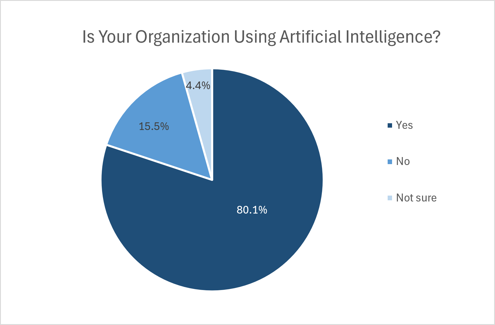
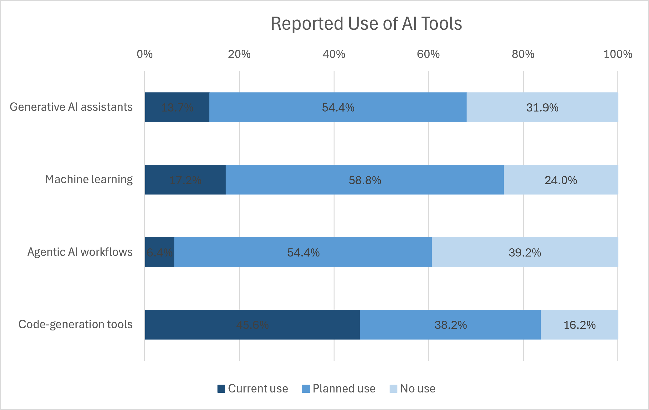
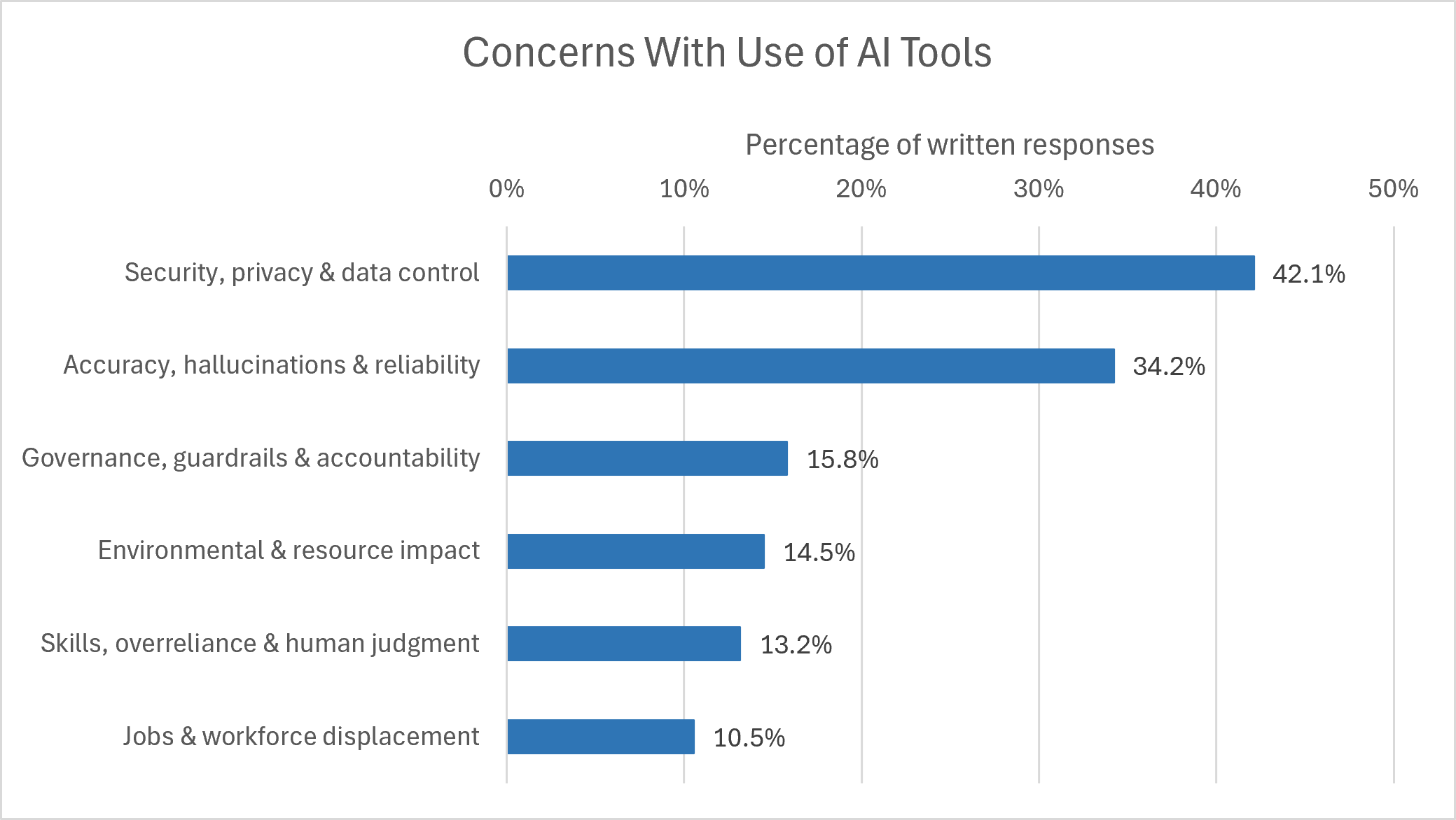
To better understand how this is showing up in practice, the Esri water team recently asked members of our community to share how they are thinking about and using AI. What we heard reflects where many utilities are today. AI is already supporting practical work, such as code generation and productivity assistance, while machine learning, generative assistants, and agentic workflows are areas of growing interest. The responses also showed that governance conversations are gaining momentum, often ahead of formal GIS implementation. To me, this signals a thoughtful and responsible approach to AI adoption, one that recognizes the opportunity while also respecting the importance of getting it right.
Defining a Purposeful Path Forward with AI
That brings the conversation back to the question that Turing raised decades ago: Can machines think? For water utilities, the more practical questions may be how computers can support their teams, whether they should, and where their use will provide meaningful value. The answers will vary by utility, use case, risk, and level of readiness. Each organization must decide when and how extensively to use AI—and where human judgment must remain central.
The water industry has always approached important innovations with purpose, and AI will be no different. Utilities are more likely to move forward when governance and validation are clear, practical applications are well understood, and the potential for progress is connected to significant operational needs. This measured approach allows utilities to explore AI while honoring their responsibility to protect public health, critical infrastructure, and community trust.
Building confidence and momentum will require practical, measurable use cases that show where AI can address big challenges, strengthen decisions, and deliver value for utilities and the communities they serve. The opportunity is not simply to make computers think for utilities, but to help each utility use AI intentionally, responsibly, and on its own terms.

Article Discussion: