Today, organizations are looking to add tactical situational awareness to their operations, which delivers accurate and timely information at the tactical level for both the command center and teams in the field. ArcGIS Mission delivers dynamic, real-time information to team members in the field, and allows field personnel to easily relay messages and observations to each other and to the command center. ArcGIS Mission is comprised of three components that work together to deliver an all-inclusive situational awareness and mission management experience.
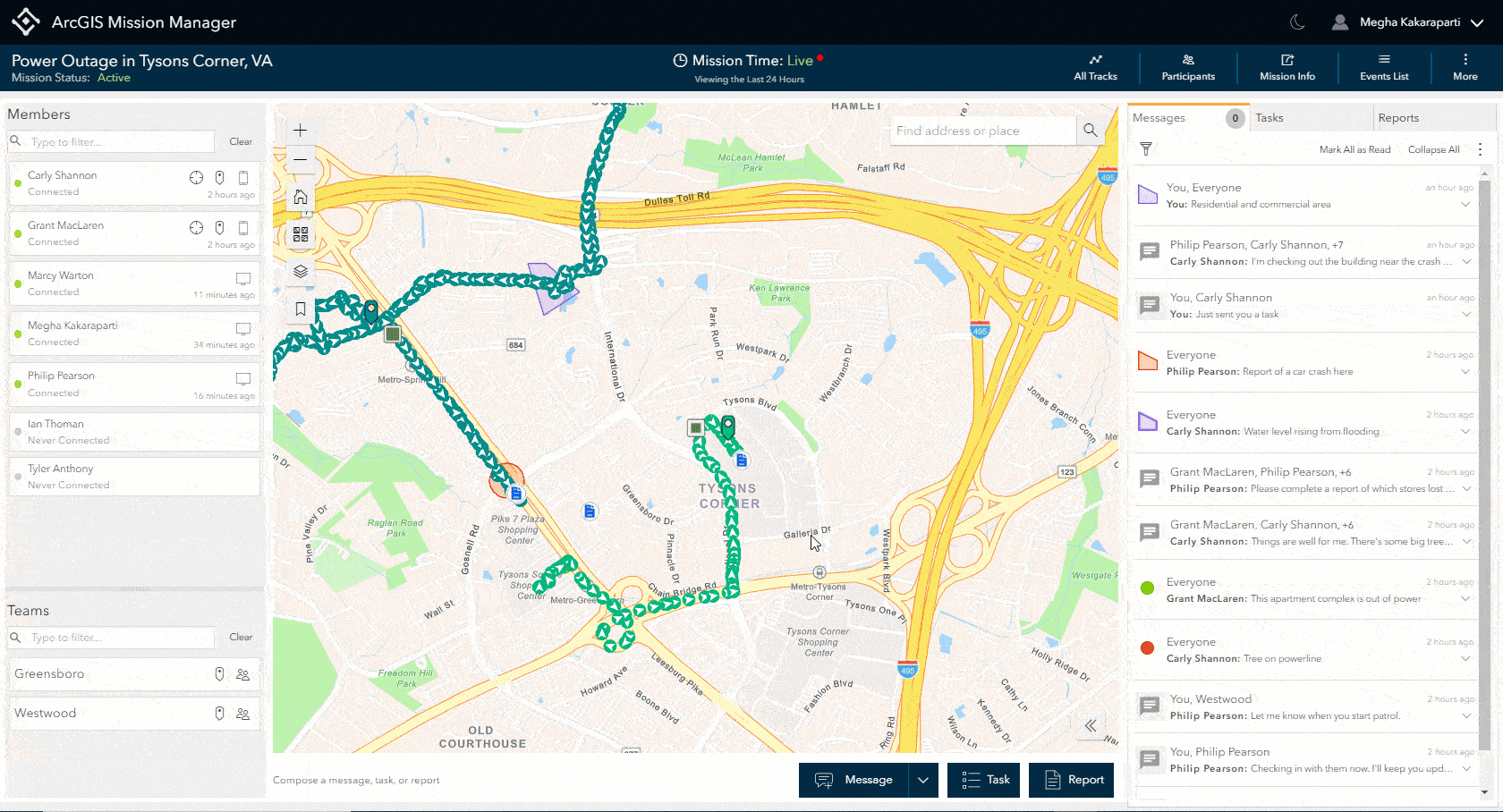
- ArcGIS Mission Manager is a premium app that organizations can use to manage their missions, assign mission members, and distribute mission content.
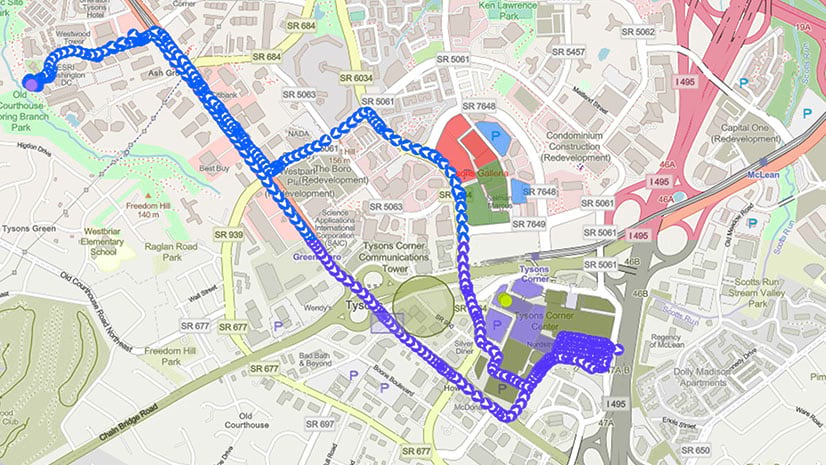
- ArcGIS Mission Responder is a mobile app that mission members can use in the field to share location tracks, map markups, and photos.
- ArcGIS Mission Server is an ArcGIS Enterprise server role that enables peer-to-peer communication among all mission team members.
10.8.1 Release Highlights
The ArcGIS Mission 10.8.1 release enhances mission management and mission response capabilities. Here are a few highlights in the upcoming release:
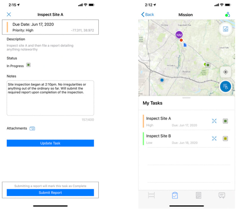
- iOS is here – ArcGIS Mission released in iOS, providing another platform to use. Like Manager, Responder users have the ability to receive and carry out tasks that have been assigned to them and can also submit reports and media.
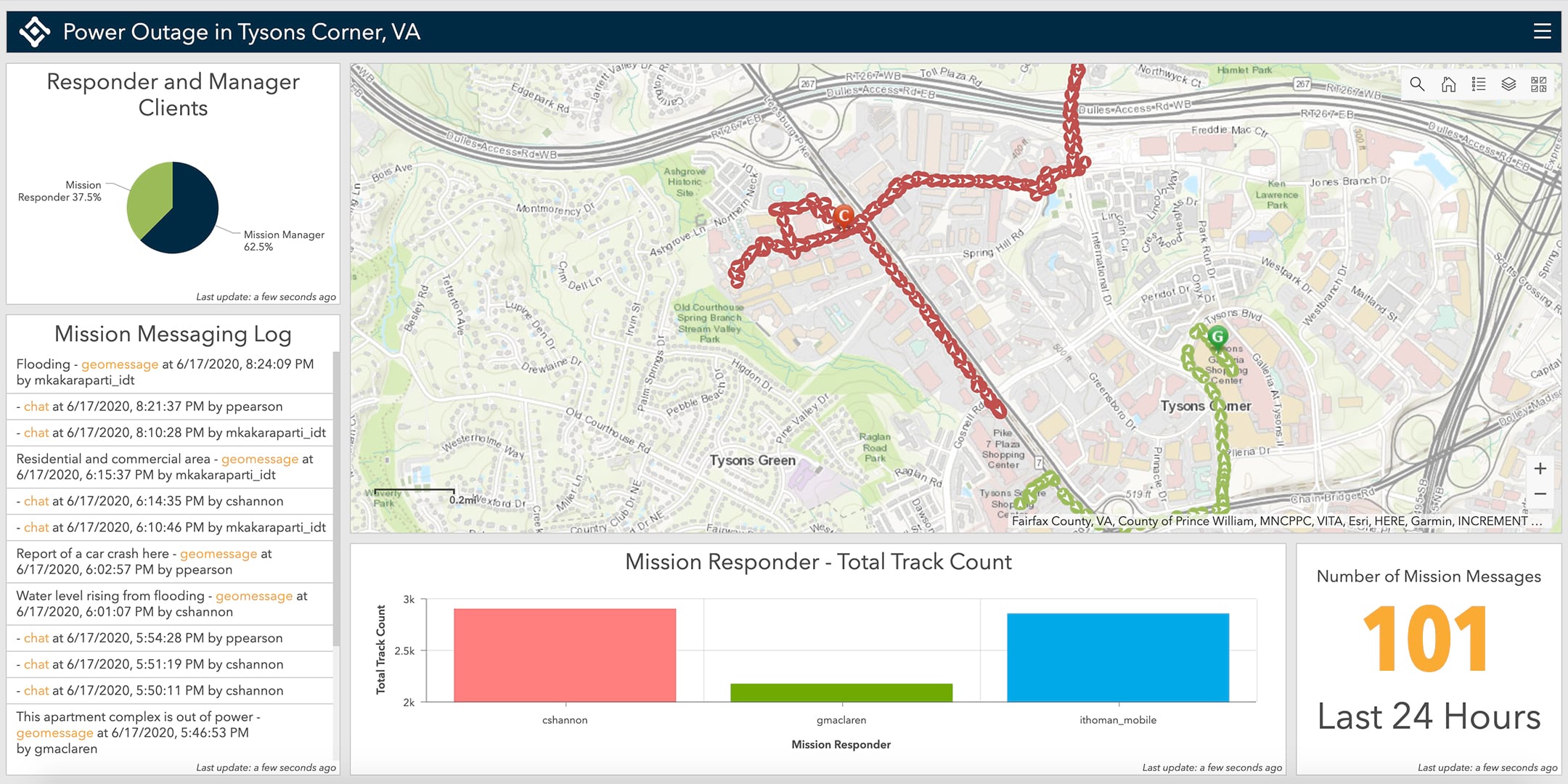
- One-click dashboards – The new ArcGIS Mission Manager experience provides a new experience to enable executives to monitor the mission activities they care about most in the familiar view of ArcGIS Dashboards.
- Assign tasks – Mission managers can now assign tasks to mission members to perform a focused job function based on a set of instructions during active missions.
- Report observations with new tactical summary reports – Responders can provide quick, tactical, in-the-field summary reports at any time to everyone in the mission.
Stay tuned for these additional enhancements coming in 10.8.1
These new additions to Mission include component updates from Mission Manager (web), Mission Responder (mobile), and Mission Server (server).
ArcGIS Mission Manager
The ArcGIS Mission Manager release streamlines the user experience with these new additions:
- Events List – The Events List provides analysts with insight into any current events that have occurred from the time you connected to the mission to include changes to the details of a mission, its members or teams, additional materials, and any edits made to the mission map. This helps provide analysts with contextual information as to what occurred and when while conducting an on-going mission.
- Mission Time – Since a mission can occur over a period of time, you have the option to temporally filter a mission to a particular date and time in the mission or to view what activity had occurred since your last connection to the mission.
These new capabilities are in addition to the one-click dashboards, Mission Reports, and Mission Tasks referenced in the 10.8.1 Highlights. Together, these enhancements support better decision-making.
ArcGIS Mission Responder
The initial release of ArcGIS Mission Responder at ArcGIS Enterprise 10.8 was available in the Google Play Store for Android. Now, at the ArcGIS Enterprise v10.8.1 release, an iOS version of Mission Responder is also available where both mobile OS platforms can be used to carry out the same mission. Similar to Mission Manager, Responder users have the ability to receive and carry out tasks that have been assigned to them and can also submit reports throughout the course of a mission based on particular events that occur.
The introduction of Tasks at the latest release provides a means for focused communication between Responder and Manager users about specific geolocated responsibilities assigned during a mission. Tasks are created by mission analysts and assigned to a single Responder user to be fulfilled as part of the mission which include providing notes and attachments from the field. All tasks assigned to you are available in the new task list which dynamically updates when tasks are updated, or new tasks are assigned to you.
Mission reports allow Responder users to gather and submit information relevant to the mission, using a predetermined and optimized format. When a report is submitted, it is available to other mission members to utilize for context and is visible on the mission map.
ArcGIS Mission Server
A major enhancement to ArcGIS Mission Server at the latest release includes the high-availability capability. Mission Server can now join and support additional machines to a server site. In addition, ArcGIS Mission Server has created new ways for developers to leverage Server REST API. These new features include:
- Mission creation – a RESTful endpoint that allows users to create missions using API calls. This is significantly different from creating missions in Mission Manager in that users can create as many missions as they need very quickly.
- Stream Layer UI – Developers now have the ability to leverage Stream Layers, bringing real-time mission data to ArcGIS Online and ArcGISPro.
Join us at Esri UC 2020
These are a few of the new features and enhancements in ArcGIS Mission that will be showcased at Esri’s 2020 User Conference. For more details on Mission’s sessions, visit our ArcGIS Mission at Esri UC 2020 post. We hope to see you at UC 2020! Can’t join us at UC? Contact us for more information.


Article Discussion: