The Esri User Conference is going virtual this year, and the ArcGIS Mission team is excited to meet you in the new conference format!
What is ArcGIS Mission?
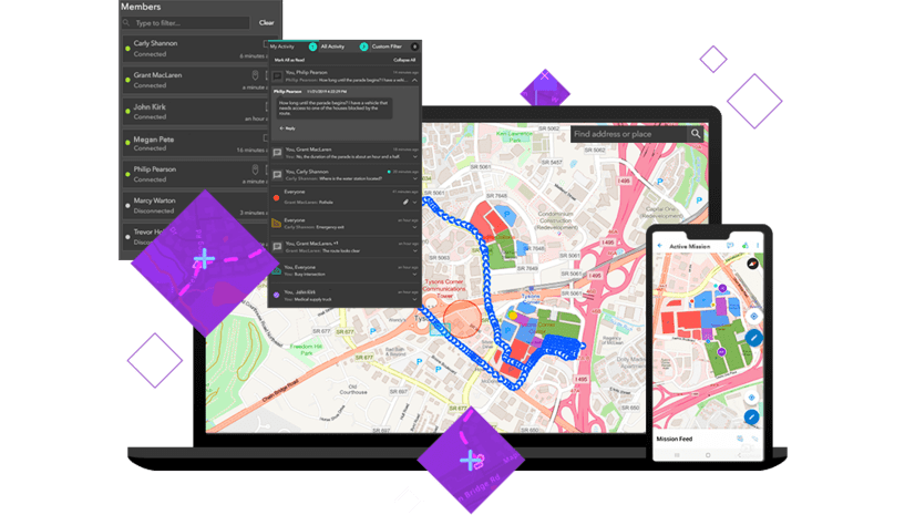
ArcGIS Mission is a situational awareness and mission-management software solution that provides organizations with a comprehensive understanding of an operating environment. Team members can track, monitor, and coordinate movement via location sharing and peer-to-peer communication. ArcGIS Mission provides the ability to assign teams, designate maps, and share documents for mission operations, providing an all-inclusive solution that gives teams the ability to make better decisions from a single authoritative system of record.
Join us at UC 2020
ArcGIS Mission will release new capabilities in July 2020, and the team is excited to share them via the live ArcGIS Mission workshop (with Q&A) on Tuesday, July 14, at 8:40am PDT. The session will be discoverable by title and Session ID (11377) in the virtual event platform. Can’t make the session or have more questions? No problem. Connect with the team in the virtual expo for a 1:1 meeting. Participation is free to all organizations current on maintenance, but individual registration is required to participate.
Demo Theater presentations available on-demand
Registered All-access participants will have access to hundreds of on-demand demo theater presentations during the conference (July 13-16) via the virtual event platform. The following sessions featuring ArcGIS Mission will be discoverable by title beginning July 13.
- “Managing Global Security Operations for Your Organization” (Speakers: Carl Walter and Kevin Armstrong |Track Title: Public Safety |Session ID: 11228)
- “Tactical Operation Coordination with Mission” (Speaker: Patrick O’Brien |Track Title: Public Safety |Session ID: 11239)
Interested in learning more before the conference?
- Learn about ArcGIS Mission: esri.com/uc2020/mission-overview
- Read what’s new in the ArcGIS Blog: esri.com/uc2020/mission-blogs
- See what’s new on the YouTube Playlist: esri.com/uc2020/mission-playlist
- Review help documentation: esri.com/uc2020/mission-help
Connect with us
- GeoNet: esri.com/uc2020/mission-geonet
- LinkedIn Group: esri.com/uc2020/mission-linkedin-user-group
- Twitter: @ArcGISApps
- Facebook: @ArcGISApps
- Instagram: @ArcGISApps
We look forward to connecting with you at UC 2020!


Article Discussion: