ArcGIS Mission is an Esri enterprise product that can meet a wide-ranging array of organizational needs. From daily safety and security operations centered around a focused area to the management of a large-scale event, ArcGIS Mission provides a constant information flow between command-based entities and field-based responders. Through positional relay of all individuals participating in a mission, customizable mission-specific reports, multi-directional communication between all members of a mission, and dispatching and tasking capabilities from the command group to responders, ArcGIS mission can help your missions run smoother. Additionally, since ArcGIS Mission is connected to ArcGIS Enterprise, anyone conducting and running a mission has constant access to their organization’s historical data combined with new data from field-based responders feeding into this same system in real time. This data can be utilized to build dashboards and fuel other applications within the ArcGIS ecosystem.
Let’s take a closer look at some of the exciting new features in ArcGIS Mission 11. 1
Landscape Mode, more Map in the Palm of your Hand
More may not always be better, but when it comes to map surface area, it can provide a better operational experience for responders in the field. At 11.1, we have worked hard to put more Mission in responders’ hands. With a simple rotation of the phone, the screen adjusts from portrait to landscape mode providing greater surface area for chats, reporting, tasking, and overall operational view. Landscape mode also provides a more comfortable operating experience for users when utilizing the functions of the app. If however, you prefer portrait mode, simply flip the phone 90°.

Admin Settings make for Smoother Configuration
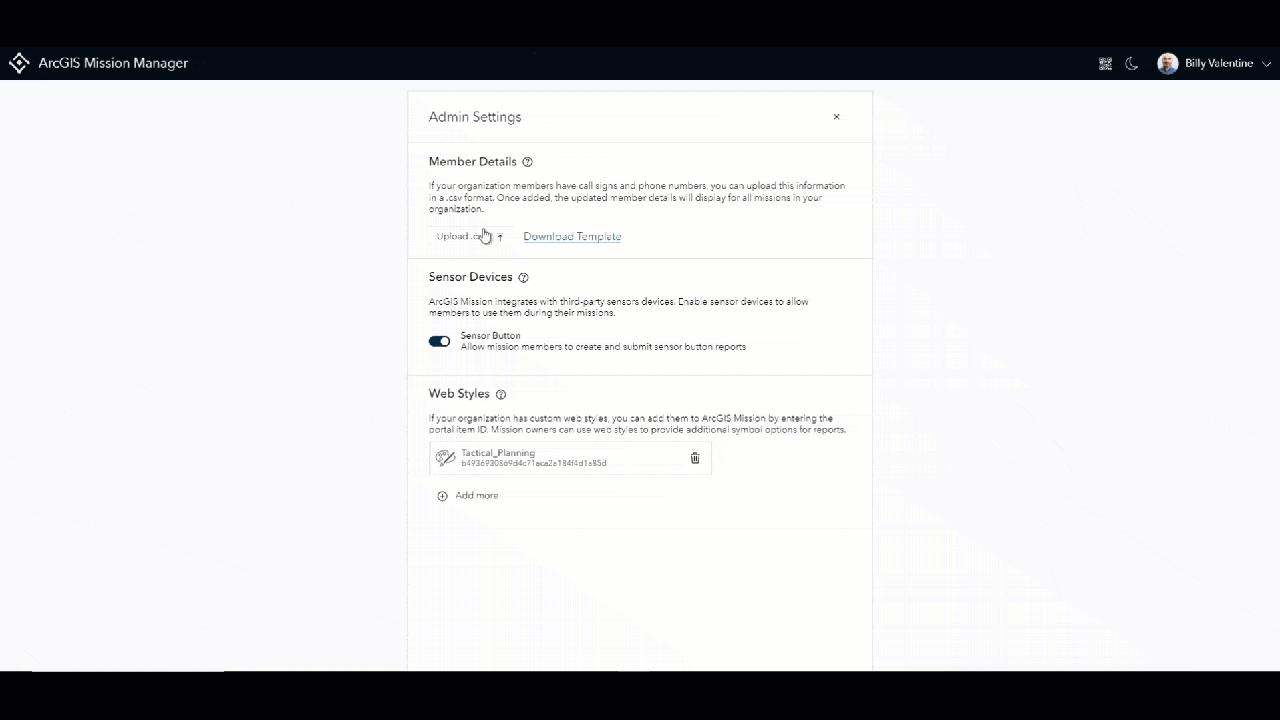
In 11.1 we make it easier for organization administrators to enable tools that allow ArcGIS Mission to do more. In prior versions, the mission administrator would access an admin REST service to enable sensor integration functionality and add web-style symbology on the user’s enterprise. Now we have exposed this service through the Mission interface with an easy-to-use UI that provides quick configuration of these same capabilities. This interface will be able to be expanded upon in future releases making mission configuration quick and easy for admins. Perhaps most exciting is the newest capability that we built into 11.1 and resides in the admin settings. To learn more, continue reading…

Configure Member Details to Add Greater Personnel Awareness
In ArcGIS Mission 11.1 we introduce the addition of a callsign and phone number assignment interface. This feature populates a portal member’s information and exposes it to the member details section providing greater personnel awareness. At the top of the admin settings page, an admin can download a CSV template that guides them through the required data structure. Once the CSV is populated with the existing portal username, call sign, 2-letter country code, area code and phone number, it can be added by one of two methods: drag and drop of the csv file or by browsing to the file and selecting it. Once the data is entered, it is appended to the user’s persona and appears in their bio card. If a portal user changes their phone number or needs to have a new call sign associated with their name; update a new csv with the information, reupload, and the old information is overwritten.
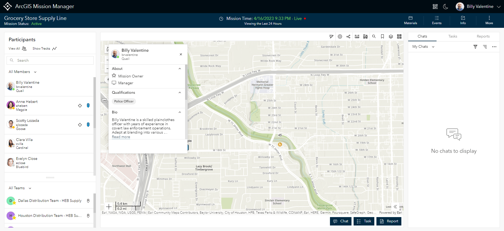
Mission Bio Cards Quickly Provide Key Information
It is one thing to know where your responders are in the field, understanding what their skills are and being able to contact them quickly however is more important. With the introduction of Member Bio Cards, all of a participant’s information that has been shared is now available while planning a mission and running one. Managers can select a person’s persona from the participants’ panel and start a chat or assign a task directly from the Bio card. Especially helpful to field personnel, is the ability to select a responder on the map, view their information, and if a phone number is associated with that member, an interface uses the phone’s calling system to dial that member directly.

Expanding Reports to Give Your Mission More Options
Over time, we have expanded upon our native reporting capabilities to make custom reports an effective, tailored experience that works for mission managers and responders alike. In 11.1 we’ve added an additional field choice when building a report; the button field. This field allows you to create a report where a button is just another option that allows for faster reporting by responders in the field. Additionally, we have expanded report creation by allowing the editing of an existing report. A report creator can now open an existing report they own and: add a question, adjust text blocks, adjust the symbology of a report, and reorder questions. When they are satisfied with their updates, they simply republish.

Keep Information Your Organization Needs
Prior to ArcGIS Mission 11.1 the question organizations needed to ask themselves when it came to a completed mission was, “To Delete, or Not To Delete”. Now the question is not whether to delete but rather what to delete and what to keep. With the enhanced mission deletion story, when delete is chosen, users can either delete the entire mission or choose to retain the content from the mission that they need to keep. Data that is kept, will remain in a user’s content folder until the decision is made on how they wish to handle that data.
What could top all that?
Aside from the previously mentioned enhancements, there are major changes to the overall look, feel, and functionality of the ArcGIS Mission experience including:
- Web Tier Authentication and full PKI support
- Quick Capture Integration
- Mission Logging
- Mission Map enhancements
- Unique Value Styling
- Labeling capabilities


Article Discussion: