With the User Conference right around the corner, now is the time to explore what’s new in AI assistants. Discover how they accelerate your workflows by troubleshooting Python code, generating metadata, or streamlining survey creation. AI assistants are embedded directly in ArcGIS apps and experiences and are designed to make ArcGIS easier to use and easier to learn, guiding you through tasks and helping you get more done across experiences.
So far, we’ve introduced several assistants in beta and preview, and now we’re ready to bring three assistants into general availability, alongside new assistants and expanded capabilities. We encourage you to explore what’s new, try out the latest features, and share your results by participating in feedback opportunities or joining Early Adopter Communities (EACs).
AI assistants in general availability
We’re excited to announce that the ArcGIS Survey123 assistant, ArcGIS Business Analyst assistant, and the translation assistant are now generally available, and are included with user types at no additional costs.
AI assistants that remain in beta or preview will continue to be accessed the same way they are today.
Moving forward, any AI assistants that transition to general availability will be included within user types, as you configure and enable them as needed.
Design surveys faster with natural conversation
The ArcGIS Survey123 assistant helps you turn ideas into structured, ready-to-use surveys without starting from scratch. Instead of manually building forms question by question, you can describe what you want and let the assistant generate a draft you can refine.
Analyze neighborhoods and customers with ease through guided suggestions
The ArcGIS Business Analyst assistant helps you move from a business question to actionable analysis faster. Instead of figuring out which tools to use, the assistant recommends workflows based on your goal. For example, you can ask it to find neighborhoods within driving distance of an aquarium with a high population of school-age children. The assistant suggests workflows such as creating drive-time areas, identifying candidate locations, and analyzing demographics using smart map search. A redesigned experience makes this easier to use, with a new launch button, a dedicated workflow pane, and a prompt gallery with examples.

Translate surveys and apps to reach more people
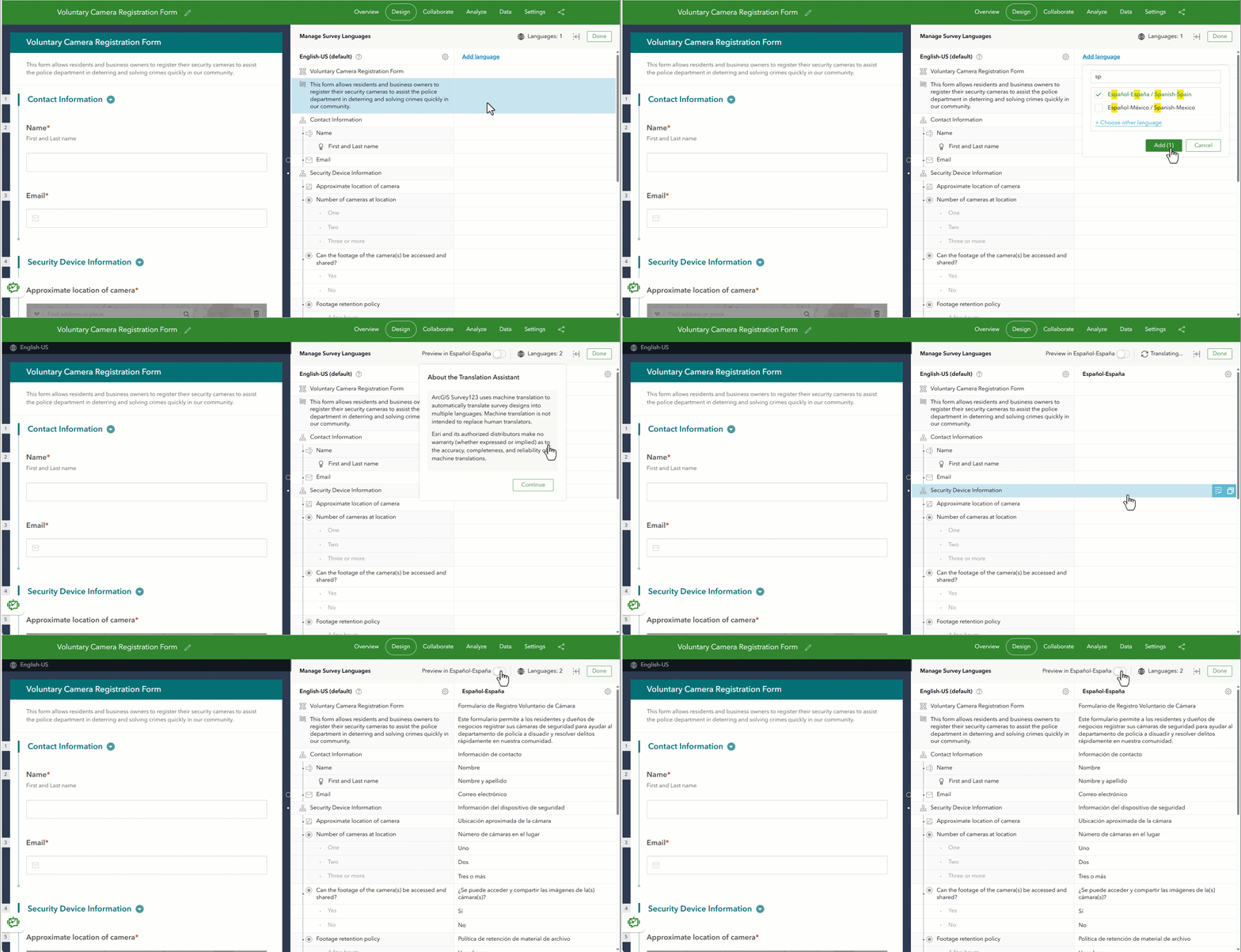
The translation assistant in ArcGIS Survey123, ArcGIS Instant Apps, and now ArcGIS Experience Builder helps you quickly make your surveys and apps accessible to more people by generating translations in multiple languages without starting from scratch. Instead of duplicating content or manually translating every question, label, or interface element, you can use the assistant to create draft translations in seconds.
New AI assistants
Run actions, get answers, and generate code with the ArcGIS Pro assistant (beta)
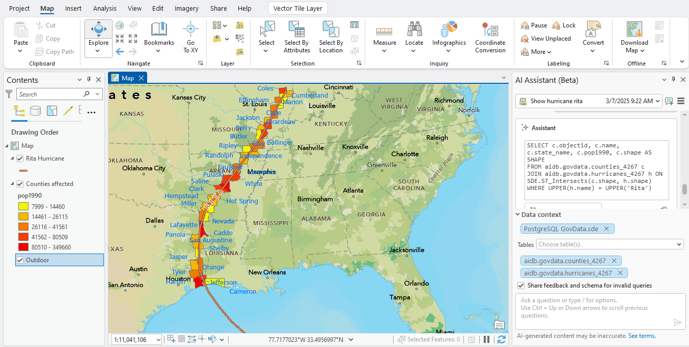
The ArcGIS Pro assistant is now in beta and available for all users to try. It is an exciting time to explore new ways to move from idea to execution faster while staying in control of your workflow. For example, use the assistant to run common actions in ArcGIS Pro, ask questions about ArcGIS, or generate ArcPy scripts, SQL query layers, and OpenCypher queries for knowledge graphs. Join the Early Adopter Community to try it out and share feedback that will directly shape how the assistant continues to improve.
Reduce workflow friction with the ArcGIS Drone2Map assistant (beta)
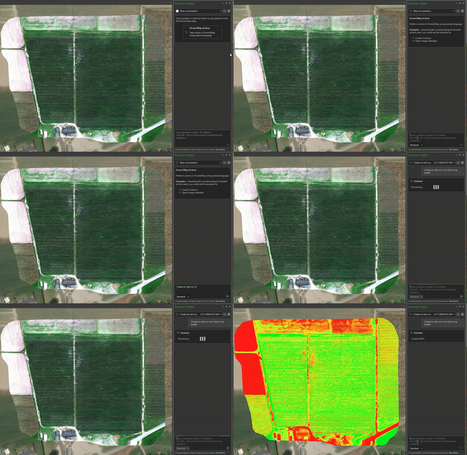
The ArcGIS Drone2Map assistant (beta) addresses common customer needs for faster support and more automated setup, particularly as drone mapping workflows grow in complexity. The assistant simplifies frequent tasks, reduces time spent searching for help, and helps users progress more quickly from imagery capture to insight. Customers interested in shaping this capability are encouraged to join the EAC (Early Adopter Community), where their feedback will directly inform future enhancements.
New enhancements in AI assistants
Improve metadata to make your content easier to find and use
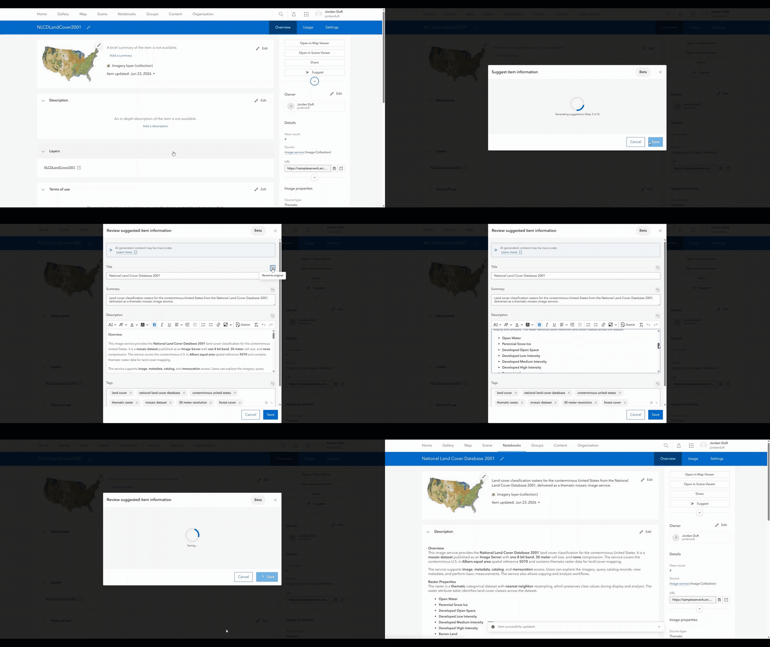
Metadata is essential for making geospatial data reusable, discoverable, and ready for AI. The Item details assistant (beta) helps you quickly create and enrich key metadata directly on the item page, reducing the effort needed to document your content. With new support for more item types, including imagery layers, map image and tile layers, and web tools, you can create metadata faster. This helps ensure your data can be better understood and used by others and supports experiences like the ArcGIS Instant Apps Data Explorer template and the ArcGIS Hub assistant that rely on strong metadata to return accurate results. Join the Early Adopter Community to help shape future enhancements.
The Item details assistant is currently available in ArcGIS Online and ArcGIS Enterprise 12.0, which is a short-term support release. Beta features are not available in long-term support releases in ArcGIS Enterprise, therefore, at this time the assistant is not available in ArcGIS Enterprise 12.1.
Generate Python and automate analysis faster in ArcGIS Notebooks
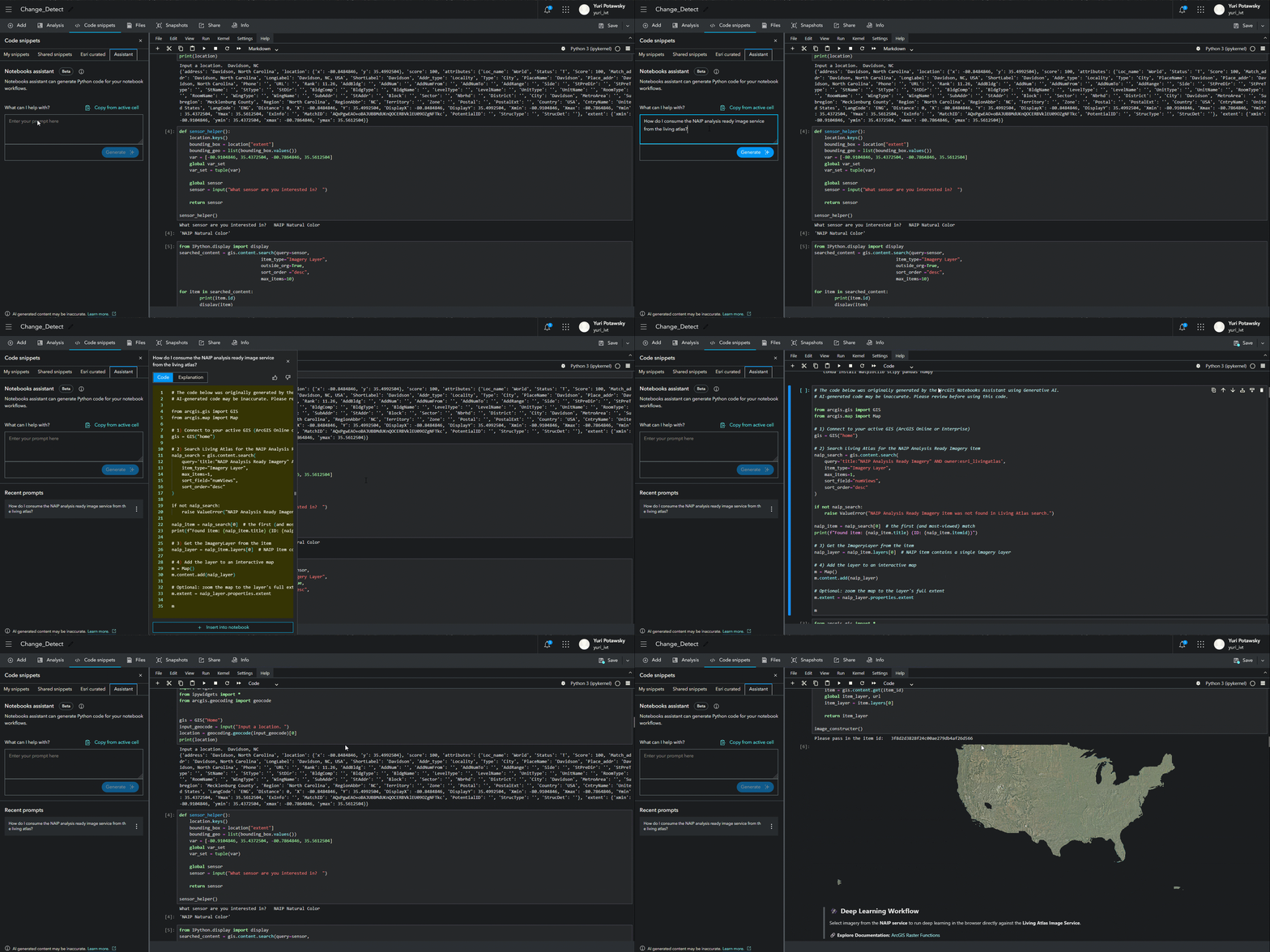
The ArcGIS Notebooks assistant (beta) brings AI directly into the notebook experience to help users work faster and with more confidence by generating, explaining, and troubleshooting Python code. Now accessed directly from the ribbon, the assistant simplifies complex tasks like building analyses, automating workflows, and understanding existing code, reducing time spent searching documentation or fixing errors.
Build your own ArcGIS Solutions with natural language
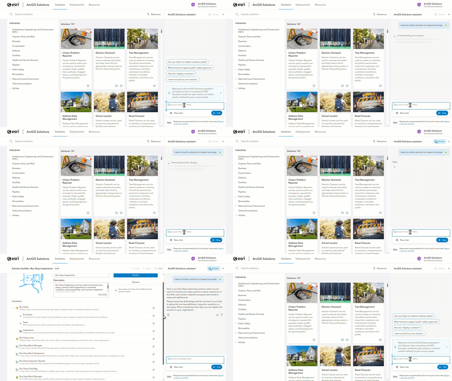
The ArcGIS Solutions assistant (beta) now allows users to build their own solution through a guided, natural language experience. In addition to helping users discover existing, industry-specific solutions, the assistant enables users to design and refine solutions that align with their organizations’ priorities. Users can adjust the solution within the assistant as needed, and deploy it directly within their organization, streamlining solution deployment.
Get quicker, more accurate answers with a smarter documentation assistant
The documentation assistant (beta) now delivers faster responses, improved accuracy, and a more natural conversational experience, helping you find answers without switching between pages or losing context. Performance improvements significantly reduce response time, while better retrieval and memory between turns help you ask follow-up questions and stay in flow. Updates like dark mode and expanded language support make it easier to access and understand documentation across products, so you can resolve questions and move forward faster.
Write, fix, and reuse expressions with the ArcGIS Arcade assistant
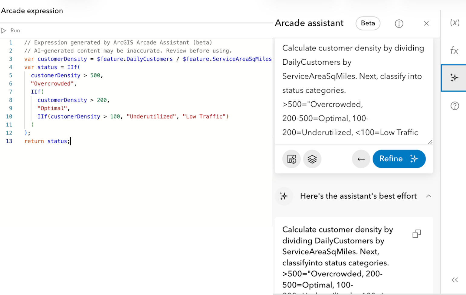
The ArcGIS Arcade assistant (beta) helps you create, troubleshoot, and refine Arcade expressions directly within your workflow, so you can move from idea to working logic without writing code from scratch. You can generate new expressions, fix errors in existing code, and quickly adapt calculations across different contexts, reducing time spent debugging or searching for syntax. Now available across Map Viewer, Field Maps Designer, ArcGIS Experience Builder, Scene Viewer, ArcGIS Data Pipelines, and the ArcGIS Maps SDK for JavaScript, it supports consistent expression building wherever you work, with continued expansion planned for ArcGIS Pro and Dashboards.
Turn ideas into compelling stories with the ArcGIS StoryMaps assistant (preview)
The ArcGIS StoryMaps assistant (preview) helps you quickly create and enhance stories by turning existing content into structured, engaging outputs. You can convert PDFs into draft stories and generate alt text to improve accessibility for maps and apps without starting from scratch. By reducing the time spent reformatting content and adding context, it helps you focus on communicating insights clearly and effectively.
Learn more at this year’s User Conference
Get ready to discover more of what’s new in our AI assistants, as well as our AI tools and models, and agentic AI through sessions happening during the UC.
Your trust and security matters
As AI assistants become more integrated into everyday workflows, trust and reliability become even more important. While we have explored the immense value AI assistants bring to ArcGIS workflows, it is equally important to address the reliability of the underlying technology. At Esri, building trust is foundational to the design, development, and deployment of AI across the entire ArcGIS platform.
Esri’s approach is grounded in a strong commitment to responsible, ethical development. As generative AI and other types of AI become more prevalent, Esri remains focused on providing security, privacy, transparency, fairness, reliability, and accountability to our users. Through measures such as human-in-the-loop design, customer opt-in controls, strict data protection practices, AI transparency cards, and formal governance structures, Esri ensures AI capabilities are trustworthy and aligned with evolving regulatory expectations. Trust in AI is a shared responsibility, and Esri encourages customers to apply appropriate oversight to use AI responsibly. Learn more with these resources:
- Trusted AI tab in the ArcGIS Trust Center: Explore guiding principles for AI
- Transparency Cards: Standardized cards that answer common questions about a generative AI features
Assistants for the user
We’re incredibly excited about what’s ahead for AI assistants in ArcGIS, and there’s never been a better time to explore what they can do in your day-to-day work. As you try them out, your feedback plays a critical role in shaping how these experiences evolve. We encourage you to share your thoughts and join Early Adopter Communities whenever possible so you can help guide development and see new capabilities firsthand. At Esri, we are committed to building AI in ArcGIS with our users at the center, ensuring these assistants are practical, trustworthy, and truly helpful for the work you do.

Article Discussion: