This October, we’ve expanded and enhanced our AI-powered assistants in ArcGIS to continue helping you drive productivity, streamline workflows, and quickly access the information you need – all with the security you’ve come to expect from our platform.
Discover how you can use these AI assistants to transform how you interact with ArcGIS. From data collection and cartographic labeling to app creation and storytelling, AI assistants make GIS tasks more intuitive and efficient.
Available in beta or preview, assistants support:
- App creation
- Mapping
- Learning
- Coding
- Storytelling
- Translation
- And more
Capabilities of AI Assistants
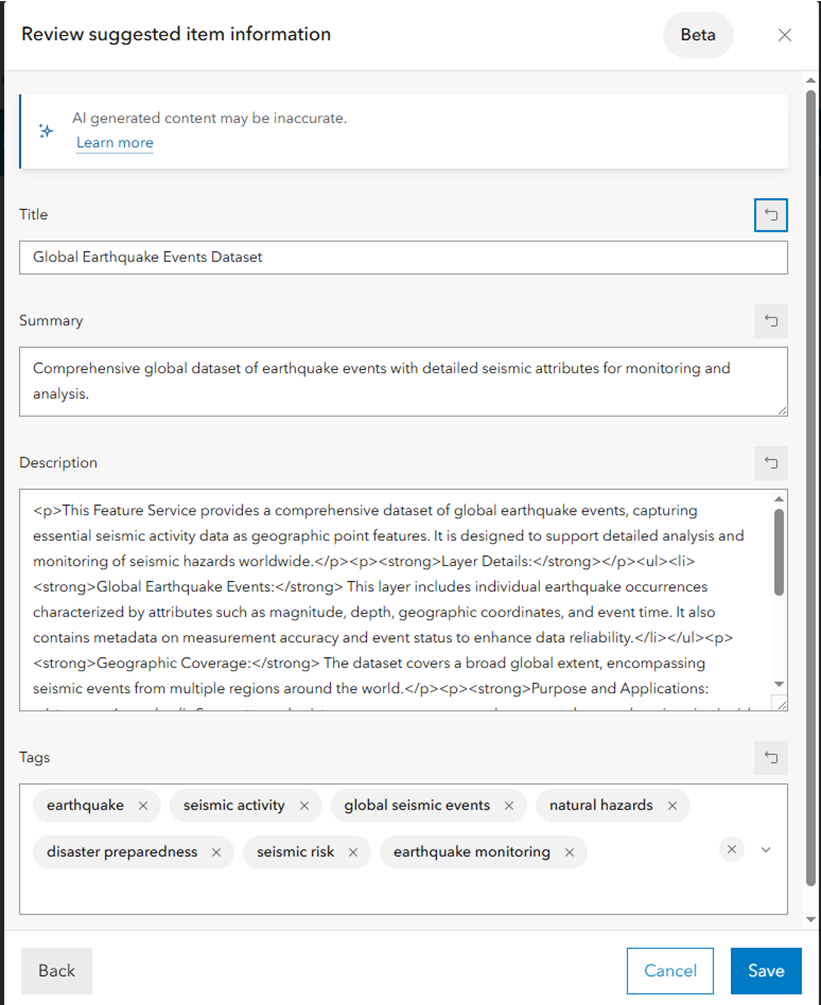
Quickly improve metadata for items in ArcGIS
Use the Item Details assistant (beta – ArcGIS Enterprise 12.0 and private beta – ArcGIS Online) for suggestions on your item titles, summaries, descriptions, tags, and field details. Find the assistant directly within the item page, and use it to enhance discoverability for yourself and for AI. Get the support you need to create meaningful, complete, and discoverable metadata, whether you are creating content from scratch or refining it. For Enterprise users, provide your feedback to the Early Adopter Community. For Online users, access to private beta is by invitation only.
Write code more efficiently with a helper for Arcade expressions
The ArcGIS Arcade assistant (beta) helps you write Arcade expressions more efficiently while showcasing available functions and how to use them. It supports a variety of tasks, including field calculations, pop-ups, attribute and element expressions, labels, renderers (smart mapping), and aggregate field expressions such as clustering or binning fields in Map Viewer. The assistant uses a consistent language and toolset across experiences and is currently available in Map Viewer, ArcGIS Web Editor, Scene Viewer, and the “My content” tab, specifically the data section for your items, in ArcGIS Online.

Compare sites and create reports and maps faster within ArcGIS Business Analyst
The ArcGIS Business Analyst assistant (preview) uses natural language prompts to help you complete common tasks faster, such as generating reports, building color-coded maps, and comparing sites. It’s designed to make mapping and analysis more accessible, whether you’re just getting started or have years of experience. By simplifying workflows, the assistant helps you focus on insights instead of interface.

Find maps, layers, and data instantly in Microsoft Teams
Accelerate your productivity with the ArcGIS for Teams assistant (beta). By using natural language prompts or search queries, you can get step-by-step guidance, relevant search results, and data recommendations making it easier to find maps, content, and ArcGIS items without ever leaving Microsoft Teams.

Equip communities to explore, understand, and act on open data with ArcGIS Hub Premium
The ArcGIS Hub assistant (beta) is designed to help you interact with open data more intuitively. Embedded within your organization’s Hub site, it interprets natural language questions and translates them into answers using the public datasets shared on that site. Available with an ArcGIS Hub Premium license, the assistant finds relevant content and returns answers, along with a map displaying related spatial data, when applicable. This makes complex data easier to understand and helps you make more informed decisions.
Explore documentation, generate code, and trigger actions with natural language in ArcGIS Pro
The ArcGIS Pro assistant (beta) enhances your experience in Pro by making it more user-friendly. With the assistant, you can explore documentation, generate ArcPy code, SQL, and Open Cypher expressions, and trigger common actions using natural language. Available now in private beta through the Early Adopter Community (EAC), access is by invitation only. To request to be added to the ArcGIS Pro AI Assistant EAC invite list, fill out this form.

Elevate storytelling skills within ArcGIS StoryMaps
The ArcGIS StoryMaps assistants (beta) helps creators craft more engaging, accessible, and visually consistent stories through intelligent, context-aware support with four assistants. The Writing assistant refines tone, structure, and clarity to make text more polished and audience appropriate. The Insights assistant provides metrics such as readability, tone, and estimated reading time, guiding authors to fine-tune their stories for maximum impact. The Accessibility assistant suggests descriptive alternative text for images to ensure inclusivity and compliance with accessibility best practices. Meanwhile, the Theme assistant generates cohesive color and font combinations based on written prompts, helping users design stories that look as compelling as they read.

Design surveys, translate content, and analyze image responses within ArcGIS Survey123
The Survey123 assistant (preview) lets you generate surveys from natural language prompts and refine them through a conversational interface in the web designer, transforming your ideas into structured questions and draft surveys. The translation capability makes it easy to localize surveys by converting questions into multiple languages in both Survey123 Connect and the web designer. Additionally, you can deploy machine learning models in the Survey123 field app to analyze image responses and automatically classify conditions, detect objects, or redact sensitive information from photos.

Get answers faster from Esri documentation
The documentation assistant (beta) provides a seamless natural language interface for interacting with Esri documentation. You can ask direct questions and receive clear, concise answers without having to manually browse through pages. The assistant helps you locate specific details, understand configuration steps, and discover best practices, making it easier to find the right information faster.

Create multi-lingual experiences in ArcGIS Instant Apps
Simplify the translation process for ArcGIS Instant Apps with the translation assistant. This powerful tool, accessed through the Language Switcher feature, helps you convert app content into multiple languages quickly, reducing manual effort. Whether you are preparing apps for global audiences or meeting specific requirements and compliances, the assistant makes it easier to deliver inclusive experiences. Keep in mind, it’s always good practice to review translations for accuracy.
Why you can trust AI in ArcGIS
Security teams within organizations often have questions about the safety of AI. We get it, and we’re here to help! We’ve got a wealth of detailed information about our AI assistants that you can share with your team to build confidence in Esri’s commitment to your security and data protection.
Here’s what we’ve got for you:
Trusted AI in ArcGIS: We’ve added a new Trusted AI tab that can be found near the top of the ArcGIS Trust Center where you can explore Esri’s guiding principles for AI, such as transparency, security, privacy, fairness, reliability, and accountability. These principles shape how we design, test, and deploy AI features across ArcGIS.
Key resources include:
- Advancing Trusted AI in ArcGIS: This document outlines Esri’s approach to responsible AI development.
- ArcGIS AI Transparency Cards: This page will progressively include standardized transparency cards as they are being rolled out. Each card answers common questions about an AI feature, such as what it does, how it works, what data it uses, and what safeguards are in place. You’ll find details on:
- Model type and deployment
- Data handling
- Privacy and security protections
- Known limitations and potential bias
- Human oversight and validation guidance
- Implementation best practices: Prepare your organization to implement Esri’s AI assistants to significantly improve decision-making, operational efficiency, and customer engagement
A note on accuracy
AI assistants are powerful tools, but like any tool, their output may vary depending on context. We encourage you to review and validate results before making decisions based on them.
Get started with AI assistants!
Currently, the assistants are available in ArcGIS Online, either in beta or preview. Preview allows users to use AI assistant features in their ArcGIS environment for a limited time and provide feedback before general release. Beta, by contrast, is an earlier release stage
To enable the assistants, go to the Settings tab on your ArcGIS Online organization page. In the AI assistants section, toggle Allow use of AI assistants by members of your organization. Note for beta access: You’ll also need to disable the Block Esri apps and capabilities while they are in beta setting, which can be found in the Security section under Apps.
To learn more and explore setup guidance and best practices, visit the AI Configuration site.


Article Discussion: