Basemaps are the foundation for every map that you author. They are the geographic canvas upon which you paint your operational layers to create effective maps and apps that inform and inspire. A good basemap provides geographic context that complements, rather than competes with, your data. The ideal basemap harmonizes with your information and provide a backdrop that highlights and clarifies your map’s core meaning.
ArcGIS Living Atlas provides a default collection of basemaps for your organization, but you can also configure a custom basemap gallery featuring your own basemaps.You can customize a basemap for a single use, or can add them to your organization’s shared gallery, making them accessible across all applications.
When crafting custom basemaps using components, you can use transparency, visbility, blending, effects, and other layer configuration options. However, not all of these are techniques are seamlessly supported across the platform. For example, layer effects such as bloom, drop shadow, and blur do not have a direct corollary in ArcGIS Pro, so those effects will be dropped to display the default when accessed in ArcGIS Pro.
Basemap components
Basemaps are composed of one or more component layers. Typically, when there is more than one component layer, they are organized into reference layers and base layers, but not always. These layers of information can include backgrounds, boundaries, physical features, terrain, and more. Reference layers alway draw on top of your operational layers, base layers are always underneath.
To view a basemap’s component layers in Map Viewer, choose Basemap from the Contents (dark) toolbar, select a basemap from the basemap pane, then click Current basemap at the top.
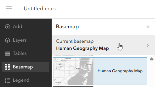
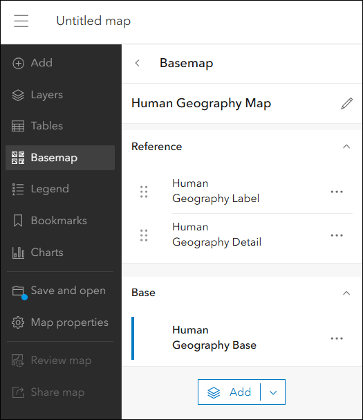
The next pane displays the component layers used in the basemap. In the case of the Human Geography basemap, there are two Reference layers (always drawn atop operational layers) and one Base layer (always under operational layers).
The Topographic basemap, which is the default for organizations, has no reference layers, only base layers.
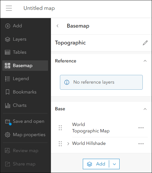
When choosing a basemap, a consideration is that different basemaps may be better suited for your operational layers. For example, because the Topographic basemap only has a single base layer, polygons added to that basemap will obscure labels. The Human Geography basemap has labels on a separate reference layer; they will always draw atop operational layers.
The Imagery Transition Basemap has one reference layer and three base layers.
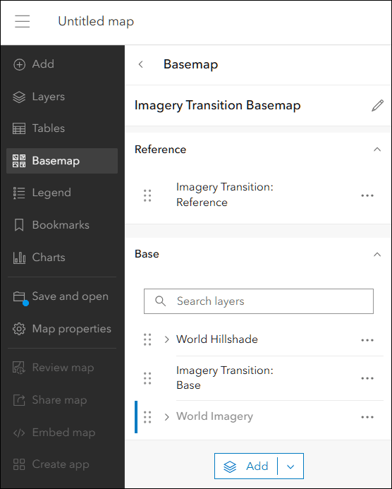
Select a base layer and view the layer properties on the Settings (light) toolbar; World Hillshade uses Multiply blending, Imagery Transition: Base has been customized using the Vector Tile Style Editor (VTSE) to enable a smooth transition to imagery, and World Imagery uses visibility scale ranges. For more information about how this basemap was constructed, see Imagery Fade-in (Blog).
Each component can contain many levels of information displayed using symbols, styles, and scales that can be edited and separated using VTSE. For example, you can separate the Topographic basemap into label reference layer and base layer components, or can modify colors and fonts. To learn more about using VTSE to modify basemaps and their components, see the following:
- Basemap sandwiches and label layers (Blog)
- Customizing Esri vector basemaps: Updates (Blog)
- Basemap basics (StoryMaps collection)
Find and use basemap components
If you want modify existing basemaps or build your own from scratch, there are several ways to find and add component layers.
Find component layers at the Living Atlas website
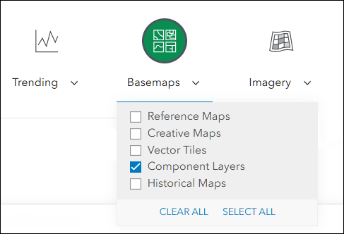
At the Living Atlas home, click the Browse tab and under Basemaps, filter for Component Layers.
The Creative Vector Tile Layers and Web Maps group also contains a variety of component layers. Filter by layers to find components you can use.
Tip: You can sign in at the Living Atlas website or the group and use Favorites to “bookmark” items for easy access later.
Find component layers via Add
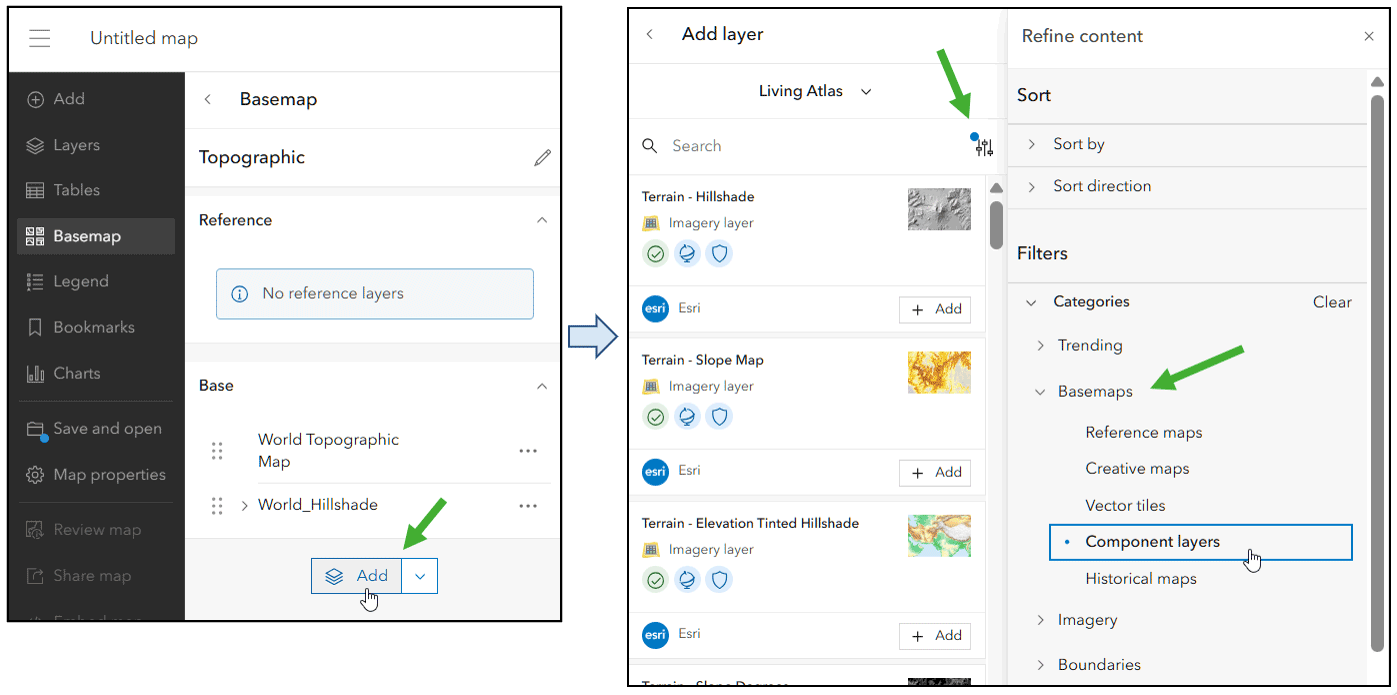
From the basemap component layers pane, click Add and select Living Atlas (or another source). When searching Living Atlas you can apply filters to search for component layers.
Borrow from another basemap
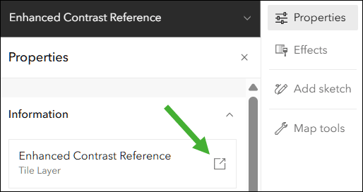
If you like a base or reference layer in an existing basemap, you can discover its source and use it in your custom basemap. For example, in the Enhanced Contrast Map you might want to take its reference layer and use it in one of your maps. From the basemap component layers pane, select Enhanced Contrast Reference, click Options (…), then Show properties.
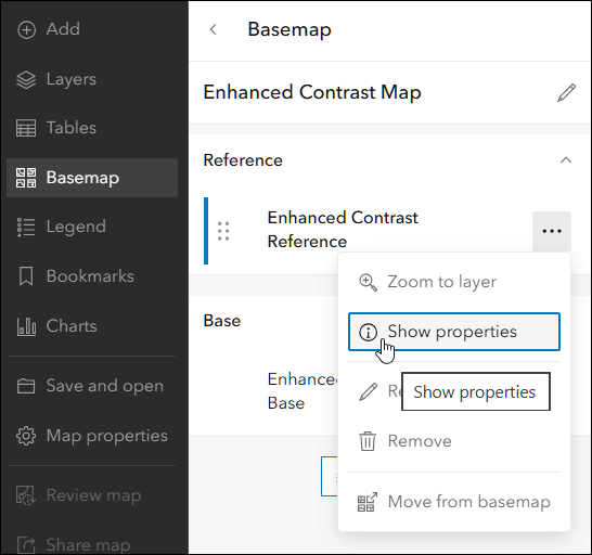
Open the Information section in the layer properties on the Settings (light) toolbar, then click the layer link. The link opens the item overview for the layer, where you can add it to a map and then move it to the basemap, or favorite the layer and add it to your basemap from your favorites.
Move a map layer to the basemap
You can move layers in your map to the basemap by clicking Options (…) then Move to basemap.
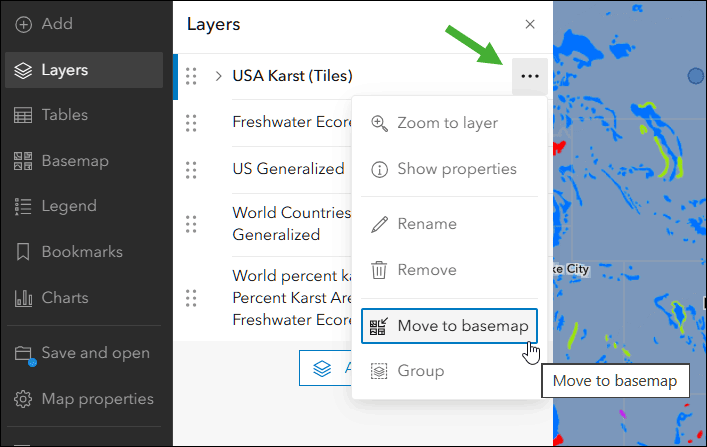
Note: Not all layer types can be moved to the basemap. For example, feature layers cannot be added to basemaps. If the layer type cannot be added, the option will not be available.
Example basemap customizations
Using component layers you can author creative basemps that are unique to your organization, and help you highlight your work. You can start with an existing basemap, or author an entirely new one from the ground up.
Human Geography
Human Geography Map is one of the default basemaps. It’s a clean canvas that does not compete with operational layers. In addition, labels are in the basemap Reference layers section, so they always draw above operational layers.
Human Geography plus terrain
To add additional context to the default Human Geography basemap, you can add World Hillshade to the base layers to create a custom Human Geography (Terrain) basemap.
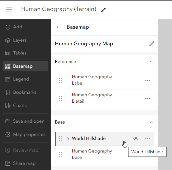
The addition of World Hillshade substantially alters the appearance of the Human Geography basemap, providing additional context to the map.
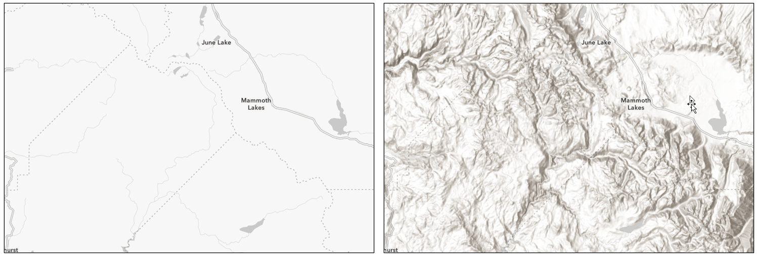
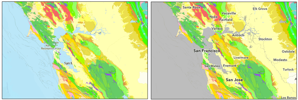
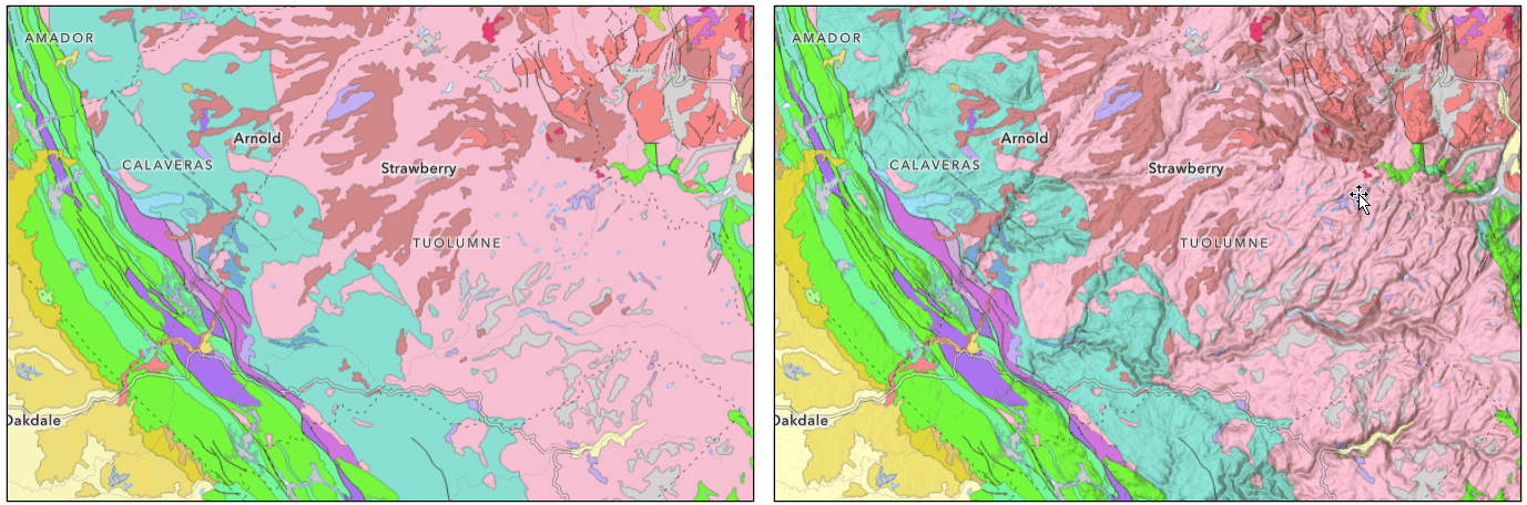
Because the basemap now includes terrain, Multiply blending can be used to enhance operational layers in the map. Shown below, California Geology has been added to the map. On the left is the default Human Geography basemap, on the right is the custom Human Geography (Terrain) basemap using Multiply blending on the geology layer.
Human Geography plus terrain, oceans, water, and land cover
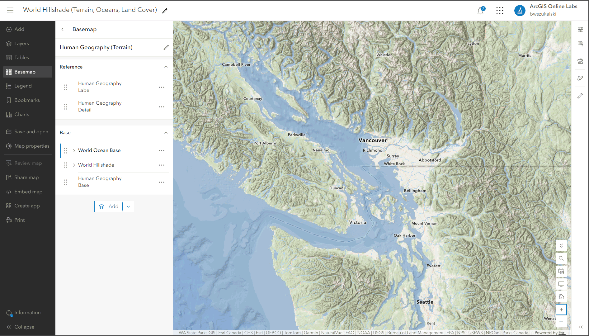
Water features are gray in the default Human Geography basemap. Building upon the Human Geography (Terrain) basemap above, you can add ocean and water features along with land cover shading to create an enhanced basemap.
The Oceans basemap applies focus on ocean areas, minimizing terrestrial features, however it omits boundaries and other features found in the Human Geography basemap. To combine the best of both, you can add the World Oceans base layer to the Human Geography (Terrain) basemap to create blue lakes and oceans with bathymetry along with land cover shading, plus still keeping the Human Geography details with terrain.
To create the final basemap, the W0rld Oceans Base layer blending was changed to Multiply to preserve the hillshaded effect.
Summary and more information
Using basemap component layers, along with other layer properties such as transparency, visibility scales, blending, and more, you can author creative custom basemaps easily for your organization. For advanced component authoring, the Vector Tile Style Editor (VTSE) can be leveraged to create custom components derived from existing basemaps.
For more information, see the following:
ArcGIS Living Atlas home (Website)
ArcGIS Online Basemaps (Group)
Choose a basemap (Help)
Choose a basemap (Video Tutorial)
Create a custom basemap gallery for your organization (Blog)
Vector Tile Style Editor home (Website)

Article Discussion: