The Scene Layers team is excited to announce new features that were added to the ArcGIS Pro 2.6 release. Lets take a look!
Integrated Mesh Modifications
At the ArcGIS Pro 2.6 release, we added functionality that allows you to modify an integrated mesh scene layer. An integrated mesh scene layer is a continuous meshed surface capturing a current state of an area or city. As it is often expensive to recreate large meshes, you may want to alter the mesh or bring other GIS content alongside the integrated mesh without re-creating the mesh and this new functionality allow you to do that.

Modifications can be created on the fly or if you have an existing building footprint or area of interest polygon you can import that as a modification and set the appropriate modification operator in the attribute table. You can access new clip, mask, and replace modifications on the Appearance contextual tab on the Integrated Mesh ribbon. Clicking on any of the buttons in the ribbon will open up the create features pane where you can select the appropriate template to sketch a modification.
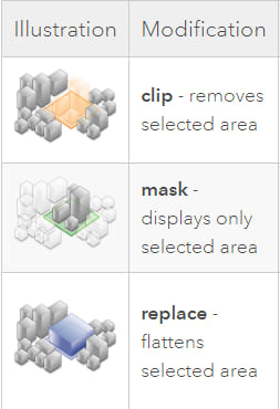
Use clip to remove a portion of the mesh. For example, expose underground utility lines at a construction site. Use mask to remove all parts of the mesh outside of the polygon modification. For example, only show one neighborhood in a city. Use a replace modification to flatten part of the mesh in order show a proposed building to stakeholders. Integrated mesh modification provides a quick way to modify your mesh and share it out to a wider audience to ArcGIS Online with support coming in the next release for ArcGIS Enterprise.
Integrated mesh draping
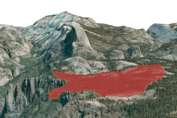
At 2.6, draping layers on integrated meshes is now supported. An integrated mesh draws as a 3D layer in the 3D category of a scene. When an integrated mesh layer is added to a scene, it will supersede the ground and basemap of that scene. Any layers that have an elevation property set to on the ground draw on the ground as well as on the integrated mesh. If a layer has an offset applied or is set at a height relative to the ground, that layer will continue to draw based on the ground only.
In the example below you can see a fire perimeter in Yosemite National Park. Draping allows better situational awareness in 3D. Combine 2D and 3D layers to derive more information by better visualizing your operational layers together. Best of all this scene can be authored in ArcGIS Pro and then shared to ArcGIS Online or ArcGIS Enterprise 10.8.1 and shared out to the public.
Building Scene Layer enhancements
Building layers can now be shared with an associated feature layer to ArcGIS Enterprise 10.8.1 with ArcGIS Online support coming in the next release. An associated feature layer unlocks additional capabilities such as attribute table access, editing, dynamic symbology, input to geoprocessing tools and relationship classes.
Filters have been possible on scene layers but with this release you can now author a filter on a building layer and share the building layer as a web scene layer or scene layer package and the filter is maintained with the scene layer.
Color and textures are now read driectly from the BIM file workspace and maintained when creating building scene layers. Textures can be enabled on the BIM Options tab by referencing an existing material library.
Share a web scene with a scene layer package
Global and local scenes with a scene layer package can now be shared as a web scene to ArcGIS Online as well as any previous version of ArcGIS Enterprise. No longer do you need to use the share package tool or individually add to your portal but you can put all operational layers in a scene and share it as a web scene.
Scene Layers with relationship classes
Scene layers with associated feature layers now support relationship classes. What this means is that you can create a one-to-one, one-to-many, many-to-one or many-to-many relationship class on a point, multipatch or building layer and author it as a web scene layer to ArcGIS Enterprise or ArcGIS Online. Relationships can be created with another feature layer or a table and must be present in the scene during the sharing process to ensure the relationship is maintained to the service.
3D Object scene layer labels
At ArcGIS Pro 2.6 labels can be added to your multipatch feature layer and shared out as a web scene layer to view across the ArcGIS Platform. Currently, labels display directly on top of the building and billboard facing the camera as you navigate the scene. Only certain properties are supported such as font, text size, and halo.
Validate scene layer tool
The validate scene layer tool has been enhanced to use the I3S validator. This tool will validate a scene layer package against the I3S specification to identify issues that may cause problems when viewing the scene layer in an ArcGIS client application. The output report defaults to a readable JSON file but can also be generated as a text or XML file.
Data Credits
Yosemite National Park Integrated Mesh: Vricon
New York City Integrated Mesh: Nearmap


Article Discussion: