ArcGIS Network Analyst, an extension to ArcGIS Pro, gives organizations the tools to perform everything from simple routing to complex transportation analysis. It’s used by planners, public works teams, GIS professionals, and logistics managers to make data-driven decisions about how vehicles move, deliver, and operate. From creating service areas to solving vehicle routing problems, ArcGIS Network Analyst supports real-world workflows with geographic precision.
If you’re still printing out a paper map once a year and hand-drawing your waste collection routes, manually piecing together routes in ArcGIS Pro, or juggling disconnected point solutions to manage sanitation, there’s finally a better way.
Until now, Esri didn’t offer a purpose-built solution for the complex realities of curbside waste routing. That changes with the latest release of ArcGIS Pro 3.5. The ArcGIS Network Analyst extension now includes the Waste Collection Solver—a new tool designed specifically for residential waste collection workflows.
With this solver, solid waste and sanitation professionals can now plan more balanced, efficient routes that reduce travel time, cut fuel costs, and improve service delivery. Whether you’re managing citywide garbage pickup, coordinating recycling routes, or consulting on municipal waste operations, this solver helps streamline your planning and get more done with fewer resources. Watch the short video to check out the tool in action.
What Makes the Waste Collection Solver Different?
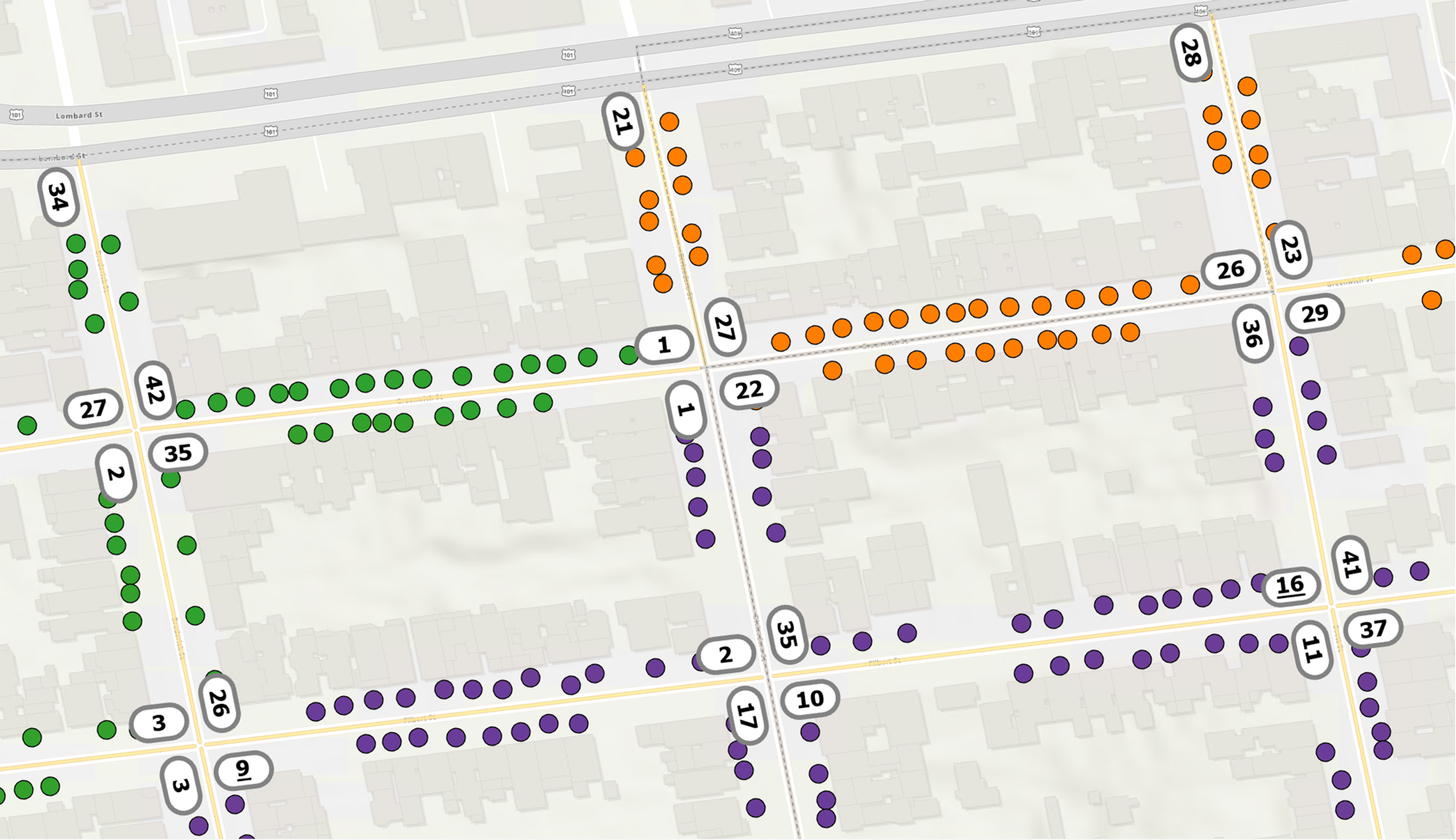
Unlike traditional routing tools that focus on point-to-point navigation, the waste collection solver is built to handle the unique challenges of residential curbside pickup. Instead of routing to individual addresses, this solver assigns road segments as the service locations, letting you specify which side(s) of the street need to be serviced. This distinction matters. Waste collection routes are not about stopping at a driveway. They are about covering streets in a regular way, avoiding overlaps, and making good paths for many vehicles that return to a depot.
With the Waste Collection Solver, you can:
- Create balanced routes across multiple vehicles (refer to Figure 1)
- Choose to service one or both sides of a street
- Minimize vehicle overlap and reduce unnecessary drive time
- Incorporate return-to-depot constraints
- Set limits on total distance or time for each vehicle
- Account for turn restrictions, barriers, and access limitations
Altogether, these capabilities give you the flexibility to model waste collection routes that reflect how work gets done in the field.

When and Where to Use It
The Waste Collection Solver is ideal for:
- Municipal solid waste pickup
- Recycling and yard waste collection
- Route planning for contracted services
- Consulting support for waste operations
- Urban planning and infrastructure impact modeling
Visualize, Share, and Improve Operations
One of the key advantages of using ArcGIS Pro is how seamlessly it connects to the broader ArcGIS system, expanding what’s possible beyond desktop route planning. Once your waste collection routes are generated and refined in ArcGIS Pro, you can visualize, edit, and prepare them for use across your organization—all within a single workflow. From there, it’s easy to share those routes with collection crews in multiple ways:
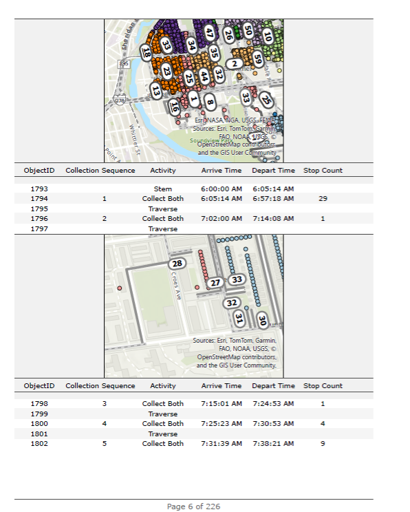
- Printed map reports for traditional workflows (refer to Figure 2)
- Web maps that update dynamically
- Mobile apps that provide turn-by-turn navigation and enable real-time adjustments
You can also integrate real-time data such as vehicle locations and fleet camera feeds alongside your routes in a centralized ArcGIS dashboard, giving operation manager and teams a clear, real-time view of operations and enabling smarter decisions in the field.
For consultants, this gives them a chance to delivering polished, ready-to-use routing solutions in a format that fits seamlessly into your client’s daily workflows.

Learn More and Get Started
Waste collection is a core public service, and with the new Waste Collection Solver in ArcGIS Network Analyst for ArcGIS Pro 3.5, you can plan more efficient curbside pickup routes, reduce drive time, and improve service delivery. Whether you’re managing daily operations, supporting long-term planning efforts, or consulting with communities, this new solver is designed to help you streamline workflows and do more with less.
How to Get Started
You can bring your own data or take advantage of Esri’s ready-to-use services with a license of ArcGIS Network Analyst extension.
Follow a hands-on tutorial in the help documentation to learn how to set up and use the solver.
Don’t Have ArcGIS Network Analyst Extension Yet?
No problem. Here is how to get access:
- Using ArcGIS Pro through an ArcGIS Desktop license? Contact Esri Sales to migrate your license at no cost to a user type and request a quote for the ArcGIS Network Analyst extension. Note: If you have ArcGIS Desktop Advanced, you’ll be upgraded to the Professional Plus user type—giving you access to an Advanced license of ArcGIS Pro and popular extensions, including ArcGIS Network Analyst.
- Already have a user type with ArcGIS Pro? Purchase an ArcGIS Network Analyst extension by contacting Esri Sales or go directly to the Esri Store. Additionally, you have the option to upgrade to the Professional Plus user type for instant access to the extension.
- New to ArcGIS Pro? Try the free ArcGIS Pro trial, which includes the Professional Plus user type, an Advanced license of ArcGIS Pro, and access to our most popular extensions—including ArcGIS Network Analyst.
Stay Connected
For more tips and resources tailored to ArcGIS Pro users:
- Follow us on X (formerly Twitter)
- Join the ArcGIS Pro LinkedIn Group
- Subscribe to the ArcGIS Pro newsletter

Commenting is not enabled for this article.